Report on Asamayama (Japan) — April 1983
Scientific Event Alert Network Bulletin, vol. 8, no. 4 (April 1983)
Managing Editor: Lindsay McClelland.
Asamayama (Japan) Summit crater explosive eruption
Please cite this report as:
Global Volcanism Program, 1983. Report on Asamayama (Japan) (McClelland, L., ed.). Scientific Event Alert Network Bulletin, 8:4. Smithsonian Institution. https://doi.org/10.5479/si.GVP.SEAN198304-283110
Asamayama
Japan
36.406°N, 138.523°E; summit elev. 2568 m
All times are local (unless otherwise noted)
JMA scientists have sent details of the explosive, summit crater eruption on 8 April. Local seismic activity had increased in mid-March, but returned to background level in late March. In early April, high-frequency B-type earthquakes and volcanic tremor were observed more frequently than usual (figure 7).
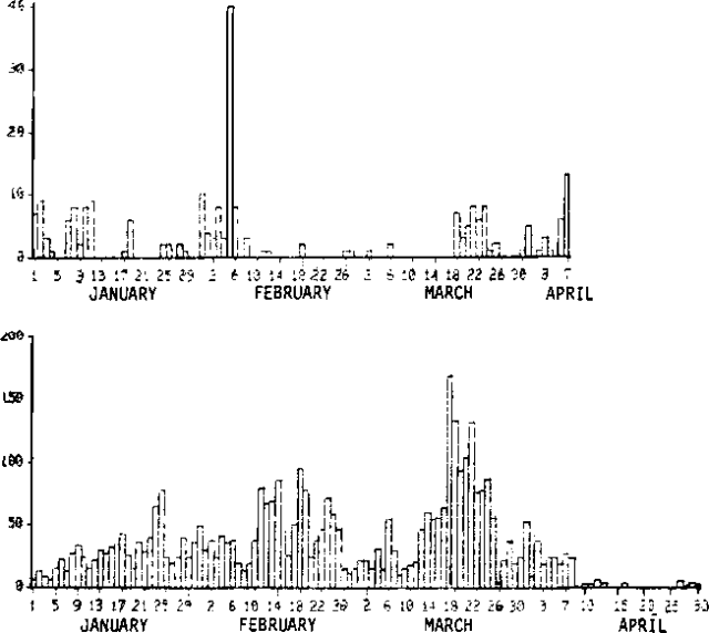 |
Figure 7. Daily number of recorded volcanic tremor events (top) and B-type earthquakes (bottom) at Asama, January-April 1983. Courtesy of JMA. |
The eruption began at 0159. The air shock (amplitude, 0.2 millibars) and eruption earthquake (amplitude, 125 µm) were recorded at the Karuizawa Weather [Station. JMA] personnel heard the thunder-like sound that accompanied the explosion, and observed the ejection of the incandescent tephra column. During the next 11 minutes, four more eruption earthquakes were recorded; seismic activity then declined rapidly. Only two volcanic earthquakes were recorded between the initial explosion and 0600, when most activity had ceased.
By 0450, when the summit was first visible from the [Weather Station], a 600-m-high, gray plume was being blown WSW from the summit. As the wind reversed during the eruption, ash was carried ENE (figure 8). Near Ko-Asama, a lava dome about 3 km E of the summit, 2.7 kg of tephra per m2 accumulated, including lapilli as large as 1 cm in diameter. By 0600 activity was limited to a 300 m-high vapor plume. No further explosions had been recorded by sunset. A forest fire started by the incandescent tephra on the S flank of Asama was extinguished by 0430.
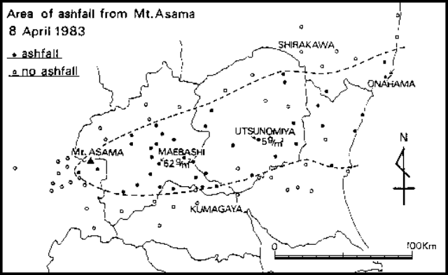 |
Figure 8. Area of ashfall from Asama, 8 April 1983. Courtesy of JMA. |
After the eruption, seismic activity declined to below background levels. Only a few seismic events per day were recorded.
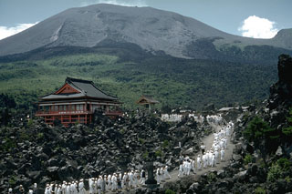
Geological Summary. Asamayama, Honshu's most active volcano, overlooks the resort town of Karuizawa, 140 km NW of Tokyo. The volcano is located at the junction of the Izu-Marianas and NE Japan volcanic arcs. The modern Maekake cone forms the summit and is situated east of the remnant of an older andesitic volcano, Kurofuyama, which was destroyed by a late-Pleistocene landslide about 20,000 years before present (BP). Growth of a dacitic shield volcano was accompanied by pumiceous pyroclastic flows, the largest of which occurred about 14,000-11,000 BP, and by growth of the Ko-Asamayama lava dome on the east flank. Maekake, capped by the Kamayama pyroclastic cone that forms the present summit, is probably only a few thousand years old and has observed activity dating back at least to the 11th century CE. Maekake has had several major Plinian eruptions, the last two of which occurred in 1108 (Asamayama's largest Holocene eruption) and 1783 CE.
Information Contacts: JMA, Tokyo.