Report on Miyakejima (Japan) — October 1983
Scientific Event Alert Network Bulletin, vol. 8, no. 10 (October 1983)
Managing Editor: Lindsay McClelland.
Miyakejima (Japan) Four lava flows, four explosion craters from 10-hour eruption
Please cite this report as:
Global Volcanism Program, 1983. Report on Miyakejima (Japan) (McClelland, L., ed.). Scientific Event Alert Network Bulletin, 8:10. Smithsonian Institution. https://doi.org/10.5479/si.GVP.SEAN198310-284040
Miyakejima
Japan
34.094°N, 139.526°E; summit elev. 775 m
All times are local (unless otherwise noted)
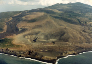
A SW-flank fissure eruption that began 3 October in mid-afternoon reached maximum intensity soon after it started and had subsided by the next morning. Frequent explosions and lava fountaining occurred from vents along a 4-km-long fissure extending SW from the island volcano's summit to the coast (figure 1), fountaining along the upper 2 km and phreatomagmatic explosions along the lower 2 km of the fissure. Lava buried 80% of the coast town of Ako, and heavy tephra falls occurred on the SE part of the island.
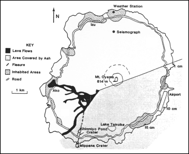 |
Figure 1. Sketch map of Miyake-jima after the eruption of 3-4 October 1983. Craters are indicated by hachured circles. Values in centimeters within the stippled area are thicknesses of new tephra at those locations. Mt. Oyama is the summit cone of Miyake-jima volcano. Courtesy of JMA. |
Pre-eruption studies. The JMA Mobile Observation Team had investigated Miyake-jima 20 August-8 September 1983 and found no unusual activity. During this investigation seismometers recorded a swarm of microearthquakes a few tens of kilometers S of the island, and another a similar distance N, but none with epicenters on the island. Temperatures, ground water chemistry and height of the steam column showed no anomalous values. From 27 December 1982 to 18 January 1983 many earthquakes, the largest of magnitude 6.1 (Ms) [JMA magnitude 6.4] at 1537 on 28 December, occurred 40 km S of the volcano, (figure 1), but no relation between them and the eruption is known.
Eruption chronology and products. JMA personnel judged that the eruption began at 1523, when the amplitude of recorded continuous tremor began to increase (figure 2). Tremor was saturating instruments by 1527. A dark eruption cloud that had reached 3 km altitude was observed from an [All Nippon Airways] airliner at 1529. People living at the foot of the volcano heard explosions at around 1530, and saw incandescent blocks and voluminous clouds of tephra ejected from points on the SW flank. Ash began to fall at the airport at 1540. The eruption column had reached an altitude of 10 km by around 1600. Lava flowing W was 0.5 km from Ako by 1630, and began surrounding and igniting houses around 1800. The southernmost lava flow entered the sea about 3.5 km SE of Ako at about 1900.
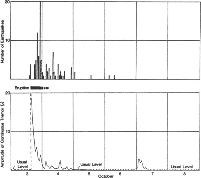 |
Figure 2. Seismicity at Miyake-jima recorded at the JMA weather station on the N side of the island, 3-8 October 1983. Data shows the number of earthquakes felt per hour (top) and amplitude of continuous tremor (bottom). On the tremor graph, the broken line indicates approximately measured data and the heavy line above the graph diagramatically shows the period of eruptive activity. Courtesy of JMA. |
Phreatomagmatic explosions began at a newly formed explosion crater (named [Shinmyo] Pond Crater) near the S end of the fissure at around 1640. At 1722, a strong explosion near the seashore, perhaps at the same crater, produced an incandescent column. Lapilli started to fall in Tsubota (about 4 km E) at 1646. The lapilli fall was heavy enough to break car windshields at around 1700, but began to decline at 1834 and ceased at 1910 as wet muddy ashfall started. At 2140 a strong explosion occurred near the shore, and about an hour later many incandescent columns were observed there but this activity paused at about 2300. A submarine phreatomagmatic explosion at the SW end of the fissure was observed from a fishing boat at around 2310. At about 0145 occasional submarine explosions were seen . . . in the same area.
A member of the JMA Mobile Observation Team arrived at Miyake-jima on 4 October at 0500. Sea and air observations at that time revealed that the fountaining had ended, perhaps about an hour earlier, and observers in aircraft saw neither explosions nor lava extrusion. Four main lava flows had moved down the SW flank. Steam rose weakly from some places on the flows, and voluminously from the SW end of the fissure where phreatic activity had occurred. Small flames seen on flow surfaces were probably from burning trees [or houses]. Lava had virtually stopped flowing, although surveyors who landed at Ako by boat observed a flow front advancing slightly. A series of pits and cinder cones had formed along the fissure in [a slightly curved line] (figure 1). Along the lower 2 km of the fissure there were four explosion craters. The largest, 300 m in diameter, was the site of submarine explosions seen during the night. It had added new land at the shore and was given the name "Mippana Crater."
The largest of the lava flows had buried 80% of Ako. It was 50 m wide in valleys, 500 m wide in the town, and 5 m thick at its front. Several homes and two schools afire at the flow front were observed from the air at 0500 on 4 October. Part of the flow advanced a few meters 4-6 October; on the 6th sea water was sprayed at 40 places along the front to halt it. At 38 of these, the flow had stopped by the next day, but spraying continued until 8 October. The E half of the island was covered with dark tephra, 15 cm deep at Tsubota, 10 cm at the airport, and 1 cm on the NE coast. The coast road around the island was closed at many places by lava flows and tephra.
Volcanologists from the Universities of Tokyo, Tohoku, Chiba, and other institutions arrived on the island 4-5 October to study the eruption and its products. Shigeo Aramaki's preliminary estimate of the volume of material ejected was [4.7] x 106 m3 of lava and [7.4] x 106 m3 of tephra (table 1).
Table 1. Estimated ejecta volumes of eruptions at Miyake-jima during 1940, 1962, and 1983 (in millions of cubic meters).
| Year | Lava | Tephra |
| 1940 | 11 | greater than 1962 |
| 1962 | 9 | 0.3 |
| 1983 | 4.7 | 7.4 |
Seismicity. Five earthquakes were felt between 1448 and 1522 on 3 October , but with the steep increase in [continuous volcanic] tremor amplitude at the start of the eruption, felt shocks stopped (figure 2). Earthquake activity remained low from 1522-1800, the most vigorous phase of the fissure eruption, then increased gradually from 1812 until 2233 when a 5.7 (Ms) [JMA magnitude 6.2] event shook the island. The few shocks felt 5-6 October represent stronger than usual seismicity. The last felt event occurred 15 October and the total since the beginning of the activity was 101. Although landslides occurred at about 10 sites along roads, there were no casualties. The number of small earthquakes then gradually decreased, but remained above background level on 27 October. . . . The amplitude of recorded continuous tremor decreased rapidly late 3 October, reaching its usual low level on 5 October, but increased again briefly early 7 October without . . . eruptive activity.
Human effects. The JMA weather station issued an alert on 3 October at 1545. Evacuation of Ako's 1400 inhabitants by fishing boat, private car and bus began immediately, as the instruction to go to Izu, on the N shore, was repeated through loudspeakers. Eleven buses moved about 1,000 persons in two round trips before the road was cut by lava at around 1730. Fishing boats transported the remaining 70. Eleven ships (from JMSA and JSDF) arrived the evening of 3 October, in case the entire island population of 4,400 needed evacuation. Food, blankets, and tanks of water were shipped from Tokyo.
Electricity was restored to all areas except Tsubota within 24 hours. Water supply to half the island was cut off because of damage to a major conduit (from Tairo-ike Pond). Telephone service was interrupted on 4 October when a switching station in Ako failed, but emergency radio service was established the same day. Tephra deposits at the airport ware cleared after 4 days, allowing it to reopen. The Tokyo government planned to build temporary housing for evacuees.
Further References. Aramaki, S., Hayakawa, Y., Fujii, T., Nakamura, K., and Fukuoka, T., 1986, The October 1983 eruption of Miyake-jima volcano: JVGR, v. 29, p. 203-230.
Special Issue -- The 1983 eruption of Miyake-jima: Bulletin of the Volcanological Society of Japan, v. 29, December 1984, 349 pp. (32 papers).
Geological Summary. The circular, 8-km-wide island of Miyakejima forms a low-angle stratovolcano that rises about 1,100 m from the sea floor in the northern Izu Islands about 200 km SSW of Tokyo. The basaltic volcano is truncated by small summit calderas, one of which, 3.5 km wide, was formed during a major eruption about 2,500 years ago. Numerous craters and vents, including maars near the coast and radially oriented fissure vents, are present on the flanks. Frequent eruptions have been recorded since 1085 CE at vents ranging from the summit to below sea level, causing much damage on this small populated island. After a three-century-long hiatus ending in 1469 CE, activity has been dominated by flank fissure eruptions sometimes accompanied by minor summit eruptions. A 1.6-km-wide summit crater was slowly formed by subsidence during an eruption in 2000.
Information Contacts: JMA, Tokyo.