Report on Home Reef (Tonga) — February 1984
Scientific Event Alert Network Bulletin, vol. 9, no. 2 (February 1984)
Managing Editor: Lindsay McClelland.
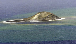
Home Reef (Tonga) Submarine eruption builds islands; tephra to 12 km
Please cite this report as:
Global Volcanism Program, 1984. Report on Home Reef (Tonga) (McClelland, L., ed.). Scientific Event Alert Network Bulletin, 9:2. Smithsonian Institution. https://doi.org/10.5479/si.GVP.SEAN198402-243080
Home Reef
Tonga
18.992°S, 174.775°W; summit elev. -10 m
All times are local (unless otherwise noted)
An eruption in the vicinity of Home Reef was reported on 2 March at 1107. Intense submarine activity ejected a plume to an altitude estimated by an airline pilot at more than 7.5 km. A surface layer, probably pumice, extended 60 km to the NE and was 20-30 km wide, enveloping Late Island (25-30 km to the NE). Surface discoloration of the sea covered a larger area. Another report at about the same time described a pumice raft of the same dimensions drifting SW. South Pacific Islands Airways (SPIA) reported that the activity was at 19.0°S, 174.80°W.
Gerald Dion piloted Pan American World Airways flight 811 (Honolulu to Auckland) over the area on 3 March at about 0730. From about 18 km upwind, the eruption was visible through broken weather clouds for about 1 minute. A medium-dark reddish-brown eruption column rose from a submarine vent within a horseshoe-shaped island open to the E. The eruption column reached slightly more than 12 km altitude (several hundred meters above the aircraft) where winds carried its top at least 15 km NE.
During the morning of 4 March, an SPIA pilot reported that an eruption cloud was still visible, rising high above the sea surface. He saw floating pumice drifting away from the eruption site but no island appeared to have formed. However, before the eruption had ended, by 5 March at 1030, two small islands had formed with a maximum elevation of about 20 m, enclosing a crater about 1,500 x 500 m. Island-forming eruptions of Home Reef occurred in 1852 and perhaps in 1857.
Geological Summary. Home Reef, a submarine volcano midway between Metis Shoal and Late Island in the central Tonga islands, was first reported active in the mid-19th century, when an ephemeral island formed. An eruption in 1984 produced a 12-km-high eruption plume, large amounts of floating pumice, and an ephemeral 500 x 1,500 m island, with cliffs 30-50 m high that enclosed a water-filled crater. In 2006 an island-forming eruption produced widespread dacitic pumice rafts that drifted as far as Australia. Another island was built during a September-October 2022 eruption.
Information Contacts: R. Krishna, Fiji Meteorological Service; J. Latter, DSIR, Wellington; G. Dion, Pan American World Airways; Meteorological Office, Tonga; W. Smith, T. Kossarias, FAA, Washington.