Report on Rabaul (Papua New Guinea) — July 1984

Scientific Event Alert Network Bulletin, vol. 9, no. 7 (July 1984)
Managing Editor: Lindsay McClelland.
Rabaul (Papua New Guinea) Seismicity declines; deformation increases
Please cite this report as:
Global Volcanism Program, 1984. Report on Rabaul (Papua New Guinea) (McClelland, L., ed.). Scientific Event Alert Network Bulletin, 9:7. Smithsonian Institution. https://doi.org/10.5479/si.GVP.SEAN198407-252140
Rabaul
Papua New Guinea
4.2459°S, 152.1937°E; summit elev. 688 m
All times are local (unless otherwise noted)
"Seismicity continued to decline in July, but some parameters of ground deformation showed an increase after a lull in June.
"The total number of caldera earthquakes for July was 4,404, compared to 13,794 in April, 8,936 in May, and 5,304 in June (figure 4). Daily earthquake totals were fairly steady, ranging from 56-280. Two small swarms of earthquakes, including one or two felt events, took place 10 and 13 July (figure 5). The swarm on the 10th occurred in the Vulcan-Karavia Bay area, while the one on the 13th was restricted to the Vulcan area. However, the total numbers of earthquakes on these days were 193 and 280, only slightly above background. Neither of these swarms was accompanied by ground deformation.
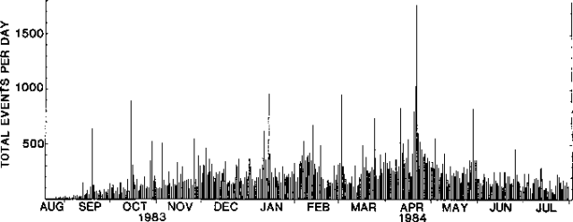 |
Figure 4. Number of earthquakes per day at Rabaul Caldera, August 1983-July 1984. |
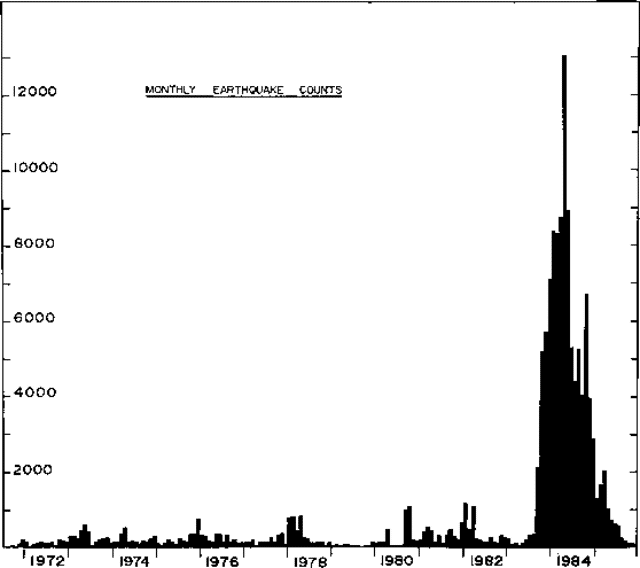 |
Figure 5. Monthly earthquakes totals at Rabaul Caldera, 1971-85. |
Although some parameters of ground deformation tended to be stronger in July than in June, none of them showed above average rates of change. Levelling measurements carried out in the last week of July indicated 38 mm of uplift at the S end of Matupit Island since late June. Only 10 mm of uplift occurred in this area 6-26 June. Horizontal distance measurements indicated a return to fairly uniform expansion across Greet Harbour, at rates of about 20-25 ppm per month. In general, tilt changes were smaller in July than in June, with most tilts less than 8 µrad. However, the station at the NW shore of Greet Harbour continued to show inflation to the SE (in Greet Harbour) at a rate of about 20 µrad per month. The pattern of tilts indicated continued weak inflation of the Vulcan and Greet Harbour areas."
Geological Summary. The low-lying Rabaul caldera on the tip of the Gazelle Peninsula at the NE end of New Britain forms a broad sheltered harbor utilized by what was the island's largest city prior to a major eruption in 1994. The outer flanks of the asymmetrical shield volcano are formed by thick pyroclastic-flow deposits. The 8 x 14 km caldera is widely breached on the east, where its floor is flooded by Blanche Bay and was formed about 1,400 years ago. An earlier caldera-forming eruption about 7,100 years ago is thought to have originated from Tavui caldera, offshore to the north. Three small stratovolcanoes lie outside the N and NE caldera rims. Post-caldera eruptions built basaltic-to-dacitic pyroclastic cones on the caldera floor near the NE and W caldera walls. Several of these, including Vulcan cone, which was formed during a large eruption in 1878, have produced major explosive activity during historical time. A powerful explosive eruption in 1994 occurred simultaneously from Vulcan and Tavurvur volcanoes and forced the temporary abandonment of Rabaul city.
Information Contacts: C. McKee, RVO.