Report on Erebus (Antarctica) — September 1984
Scientific Event Alert Network Bulletin, vol. 9, no. 9 (September 1984)
Managing Editor: Lindsay McClelland.
Erebus (Antarctica) Vigorous explosions, clouds, and incandescent tephra
Please cite this report as:
Global Volcanism Program, 1984. Report on Erebus (Antarctica) (McClelland, L., ed.). Scientific Event Alert Network Bulletin, 9:9. Smithsonian Institution. https://doi.org/10.5479/si.GVP.SEAN198409-390020
Erebus
Antarctica
77.53°S, 167.17°E; summit elev. 3794 m
All times are local (unless otherwise noted)
"Brief reports from technical staff operating seismic instruments at Scott Base and infrasonic equipment at McMurdo Sound indicate a significant change in eruptive activity at Mt. Erebus. Activity associated with the lava lake has consisted of quiet degassing with emission of ~230 t/d of SO2 and 21 t/d of aerosol particles. Two to six small Strombolian eruptions occurred per day, often ejecting bombs of anorthoclase phonolite onto the crater rim, ~220 m above the lava lake.
"The reports indicate that starting on 13 September a number of large explosions were recorded by the IMESS network situated on the volcano, by infrasonic detectors in Windless Bight (~29 km away), by the WWSSN seismograph at Scott Base (37 km distant), and by a tidal gravimeter at South Pole station (~1,400 km from Mt. Erebus). Previous Strombolian activity has generally been too weak to record except on the IMESS seismic stations.
"From 13 to 19 September, the volcano was very active with 8-19 large explosions (recorded on WWSSN, IMESS, and infrasound instruments) per day, decreasing to 2-8/day 20-25 September, then increasing again to 12-27 explosions per day 26-29 September. Numerous mushroom-shaped clouds were reported, and were estimated to rise as much as 2 km above the summit. Observers at McMurdo, 37 km SW of the volcano, reported hearing explosions on 16 September at 0459, and 26 September at 1133 and 1135. Slight earth tremors were also felt there. On 17 September at 1010, a bright summit glow was observed from McMurdo Sound. Six minutes later, incandescent bombs were ejected to ~600 m above the summit; observers at Butter Point, 70 km from the volcano, reported seeing incandescent tephra from this explosion, which produced one of the larger infrasonic and seismic signals of the eruption sequence.
"Ash covered the NW side of the volcano down to 3,400 m elevation. Fumaroles around the summit crater showed a substantial increase in activity. A 300-500-m-high very narrow plume was observed lower on the E flank (1,800 m?). Observers suggested that it might have been a geyser."
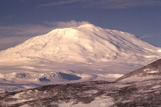
Geological Summary. Mount Erebus, the world's southernmost historically active volcano, overlooks the McMurdo research station on Ross Island. It is the largest of three major volcanoes forming the crudely triangular Ross Island. The summit of the dominantly phonolitic volcano has been modified by one or two generations of caldera formation. A summit plateau at about 3,200 m elevation marks the rim of the youngest caldera, which formed during the late-Pleistocene and within which the modern cone was constructed. An elliptical 500 x 600 m wide, 110-m-deep crater truncates the summit and contains an active lava lake within a 250-m-wide, 100-m-deep inner crater; other lava lakes are sometimes present. The glacier-covered volcano was erupting when first sighted by Captain James Ross in 1841. Continuous lava-lake activity with minor explosions, punctuated by occasional larger Strombolian explosions that eject bombs onto the crater rim, has been documented since 1972, but has probably been occurring for much of the volcano's recent history.
Information Contacts: P. Kyle, New Mexico Inst. of Mining & Tech.; J. Kienle and C. Wilson, Univ. of Alaska.

