Report on Colima (Mexico) — November 1985

Scientific Event Alert Network Bulletin, vol. 10, no. 11 (November 1985)
Managing Editor: Lindsay McClelland.
Colima (Mexico) New fissures; fumaroles to 800°C; felt seismicity
Please cite this report as:
Global Volcanism Program, 1985. Report on Colima (Mexico) (McClelland, L., ed.). Scientific Event Alert Network Bulletin, 10:11. Smithsonian Institution. https://doi.org/10.5479/si.GVP.SEAN198511-341040
Colima
Mexico
19.514°N, 103.62°W; summit elev. 3850 m
All times are local (unless otherwise noted)
"Dartmouth volcanologists visited Colima 26-27 November. Large linear fractures had opened on the NE flank of the volcano between the summit and Volcancito Cone, at an elevation of approximately 3,700 m (figure 1). These fractures strike N30-45°E and are as much as 15 m deep, 5 m wide, and 50-100 m long. New arcuate fractures of comparable size are concave downslope and head across the linear fractures. Fumarolic activity in an area of 100 m2 was intense with temperatures up to 800°C and several fumaroles hotter than 600°C. Fracturing and fumarolic activity persisted at higher elevations, but was concentrated below the summit. Hundreds of tremors were felt during a bivouac near the fumarole field on the night of 26 November. A small fissure was observed cutting across the summit of Volcancito roughly in line with those found at higher elevations. Temperatures in this fissure were 40°C. This is a marked change in activity since our group last visited Colima in April 1983, when fractures and fumarolic activity were not observed in this area. The 1983 fumaroles were located at higher elevations and were much cooler; highest temperature was 565°C."
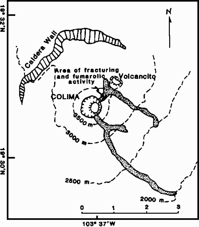 |
Figure 1. Location of the area of active fracturing and intense fumarolic activity on Colima. The 1975-76 lava flow is shaded. Base map modified from Luhr (1981). |
Geological Summary. The Colima complex is the most prominent volcanic center of the western Mexican Volcanic Belt. It consists of two southward-younging volcanoes, Nevado de Colima (the high point of the complex) on the north and the historically active Volcán de Colima at the south. A group of late-Pleistocene cinder cones is located on the floor of the Colima graben west and east of the complex. Volcán de Colima (also known as Volcán Fuego) is a youthful stratovolcano constructed within a 5-km-wide scarp, breached to the south, that has been the source of large debris avalanches. Major slope failures have occurred repeatedly from both the Nevado and Colima cones, producing thick debris-avalanche deposits on three sides of the complex. Frequent recorded eruptions date back to the 16th century. Occasional major explosive eruptions have destroyed the summit (most recently in 1913) and left a deep, steep-sided crater that was slowly refilled and then overtopped by lava dome growth.
Information Contacts: C. Connor, B. Gemmell, and R. Stoiber, Dartmouth College.