Report on Piton de la Fournaise (France) — January 1986

Scientific Event Alert Network Bulletin, vol. 11, no. 1 (January 1986)
Managing Editor: Lindsay McClelland.
Piton de la Fournaise (France) Summit lava production continues
Please cite this report as:
Global Volcanism Program, 1986. Report on Piton de la Fournaise (France) (McClelland, L., ed.). Scientific Event Alert Network Bulletin, 11:1. Smithsonian Institution. https://doi.org/10.5479/si.GVP.SEAN198601-233020
Piton de la Fournaise
France
21.244°S, 55.708°E; summit elev. 2632 m
All times are local (unless otherwise noted)
"The eruptive episode that began on 29 December inside the central (Dolomieu) crater (10:12) was still in progress on 31 January. The main cone, in the SW part of the crater (figure 16), reached a height of 40 m. Explosive activity was less important than during the first few days of the eruption. The vent emitted lava fountains to 20-50 m above the crater rim during the first weeks of January; afterward, fountains were limited to 15 m height. More than 95% of the crater floor has been covered by the new lava flow; maximum thickness was 20-25 m in the NE part of the crater. The total volume of the emitted lavas was ~7 x 10⁶ m3 as of 30 January. All the lavas are aphyric basalts.
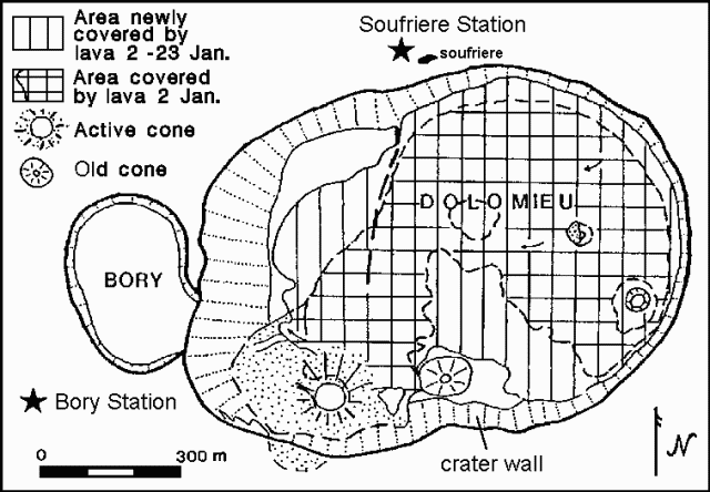 |
Figure 16. Map of the summit craters of Piton de la Fournaise as of 23 January 1986. Courtesy of the OVPDLF. |
"Tilt stations around the summit craters indicated a general deflation (15-70 µrads) after the beginning of the eruption. No significant movement was recorded between 8 and 22 January. The plume was still very rich in SO2, and numerous fumaroles were found at the base of the main cone on top of the lava tubes.
"The seismic station close to Bory Crater (just W of Dolomieu Crater) was saturated during the whole month. The Soufrière station (300 m NNW of Dolomieu Crater) received significant signals from the tremor. This tremor has begun to decrease since 20 January on all stations except Bory. Major tremors affected the walls of the Dolomieu Crater, causing collapse and forming numerous cracks on the S rim and the rim between Bory and Dolomieu".
Reference. Blum, P., Gaulon, R., Lalanne, F., and Ruegg, J., 1981, Sur l'evidence de precurseurs de l'eruption du Piton de la Fournaise a la Réunion (Fevrier 1981): Comptes Rendus Acad. Sci. Paris, v. 292, serie II, p. 1449-1455.
Geological Summary. Piton de la Fournaise is a massive basaltic shield volcano on the French island of Réunion in the western Indian Ocean. Much of its more than 530,000-year history overlapped with eruptions of the deeply dissected Piton des Neiges shield volcano to the NW. Three scarps formed at about 250,000, 65,000, and less than 5,000 years ago by progressive eastward slumping, leaving caldera-sized embayments open to the E and SE. Numerous pyroclastic cones are present on the floor of the scarps and their outer flanks. Most recorded eruptions have originated from the summit and flanks of Dolomieu, a 400-m-high lava shield that has grown within the youngest scarp, which is about 9 km wide and about 13 km from the western wall to the ocean on the E side. More than 150 eruptions, most of which have produced fluid basaltic lava flows, have occurred since the 17th century. Only six eruptions, in 1708, 1774, 1776, 1800, 1977, and 1986, have originated from fissures outside the scarps.
Information Contacts: H. DeLorme and J-F. DeLarue, OVPDLF; P. Bachelery, Univ de la Réunion.