Report on Nevado del Ruiz (Colombia) — February 1986
Scientific Event Alert Network Bulletin, vol. 11, no. 2 (February 1986)
Managing Editor: Lindsay McClelland.
Nevado del Ruiz (Colombia) Strong SO2 emission; seismicity declines slightly
Please cite this report as:
Global Volcanism Program, 1986. Report on Nevado del Ruiz (Colombia) (McClelland, L., ed.). Scientific Event Alert Network Bulletin, 11:2. Smithsonian Institution. https://doi.org/10.5479/si.GVP.SEAN198602-351020
Nevado del Ruiz
Colombia
4.892°N, 75.324°W; summit elev. 5279 m
All times are local (unless otherwise noted)
Colombian geologists reported that microseismic activity diminished between mid-February and mid-March, with an average of 5 high-frequency and 12-15 low-frequency events daily. Seismic events of mixed frequency also diminished, to 1/day. Activity on 28 February was abnormally low, with only one low-frequency event. Epicenters were within 3-4 km of the crater, and focal depths were at 1-3 km below a datum at 4.7 km above sea level . . . .
The vapor column reached heights of 100-800 m, without significant ash emission. Rates of SO2 emission measured by COSPEC in early March were generally of the order of 500 t/d; during the afternoon of 4 March, values of ~1,000 t/d were recorded, about the same as a month earlier. Fissures in pyroclastic material on glaciers on the NE part of the volcano showed displacements of 20-30 mm/day. Electronic tilt instruments recorded ~0.1 µrad of inflation/day on the W flank. No significant changes were detected on the E flank.
Additional seismic information comes from Jim Zollweg. "After the 13 November eruption, a 6-station telemetry network was installed around the volcano. All stations use vertical 1-Hz seismometers and radio-telemeter to the Comité de Estudios Vulcanológicos headquarters in Manizales. Sites were chosen 4-10 km from Arenas, Ruiz's active crater. The first station was operating on 17 November, four stations were functioning by 28 November, and all six by 2 December, although some locations were changed later. Recording is analog using pen-and-ink or smoked paper.
"Seismic activity was moderate in November and December, consisting chiefly of high-frequency earthquakes with magnitudes to 3.5. There were about half as many low-frequency as high-frequency earthquakes during those months. About 1,300 earthquakes were counted in December (countable events had coda lengths of at least 5 seconds on the Olleta telemetry station). In January, activity was considerably lower because of a major decrease in the rate of occurrence of high-frequency events. Only a few surface-type events (gas emission signals or avalanches) were recorded by telemetry stations in any month. Instances of harmonic tremor sustained for more than a minute were also uncommon, particularly in December. The most important tremor recorded since the stations were installed occurred 3-5 January, preceding and during a minor eruption 4-5 January. This tremor was unusual because of its wide range of frequency content; frequencies of 7 Hz or more were recorded within a few hours of its onset, and frequencies as low as 0.7 Hz occurred later in the episode.
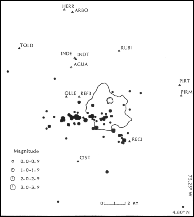
"Very few low-frequency earthquakes have been locatable, and those with epicenters that could be computed usually occurred near Arenas Crater (within the limits of accuracy of the solutions). More than 150 high-frequency earthquakes have been located, and 81 of the better solutions are plotted in figure 6. Events were located using the program HYPOINVERSE, and an ad-hoc crustal model based on geological considerations. Events plotted within the network have epicentral 95% confidence limits of 1 km or less. Those plotted outside the network may have epicentral 95% confidence limits as poor as 3 km, depending on distance from the network. Focal depths of the high-frequency events are usually between 2 and 5 km (beneath a datum at 4.7 km asl), but depend on the crustal model used. The probable error range makes it difficult to say whether there are significant depth differences between events.
"Most of the high-frequency earthquakes occurred in one of two linear zones that intersect under the center of Ruiz. The E-W-striking zone is ~6 km long and was responsible for most of the seismicity. There is an interesting temporal pattern to the epicenters. Locations between 28 November and 5 December mainly fell in the central and eastern parts of the E-W zone, whereas vigorous swarms 6-13 December were mainly confined to the W half of the zone. There was a pronounced hiatus in high-frequency activity 14-21 December, followed by a swarm of events 22-25 December along the second zone, striking NW-SE. Between 26 December and 3 January, earthquakes reverted to a small area near the intersection of the two zones. High-frequency activity was comparatively low in the weeks following the 4-5 January eruption. First motions have been mostly compressions for nearly all events under Ruiz, suggesting a normal faulting environment. The data for the high-frequency sequences suggest the intrusion of dike-like bodies of magma along pre-existing fault zones."
Deformation monitoring has been summarized by Barry Voight. "Preliminary data from EDM reflector stations suggest that much of the observed summit surface deformation is due to ice movement decoupled from underlying bedrock. The data place constraints on the volume of rock susceptible to massive gravitational failure. EDM reflector stations (Martica and Finger) were installed at ~5,100 m elevation near the center of the Río Azufrado headwall. They were first measured on 14 February. Preliminary data from repeated distance measurements to 7 March suggest that the motions of glacier ice and underlying bedrock are decoupled. The fracture pattern observed on the surface of the summit plateau E of Arenas Crater dominantly reflects the propagation of crevasse patterns through the veneer of surficial deposits. The steady outward motion of the summit area as deduced from observation of surficial fracturing and EDM monitoring mainly reflects movements in glacier ice rather than motion of underlying bedrock. At other locations, some cracks give the appearance of possibly extending into bedrock, for example at the septum separating the crater from the headwall of the Río Azufrado. Although my current impression is that all of the headwall is probably stable with respect to deep-seated rock failure, the potential for mass movement involving a portion of the crater remains to be thoroughly evaluated."
Fabian Hoyos P. reported that isotopic analyses of several hot springs and the crater fumarole were sampled on 8 July 1985 in cooperation with the Central Hidroeléctrica de Caldas (CHEC). Isotopic compositions of 8 July 1985 hot spring samples were similar to those reported in 1968 and 1980 to CHEC. Water vapor collected the same day from the summit crater fumarole had an isotopic composition corresponding to that of meteoric water precipitated at ~2,800 m asl (table 2). Other samples collected until just before the 13 November eruption are being analyzed.
Table 2. Isotope analyses by Sara Kealy, Arizona State Univ, of samples collected from fumaroles at Ruiz, 8 July 1985. Data courtesy of Fabian Hoyos P. and Sara Kealy.
| Source | delta 18O | delta D |
| Aguas Blancas Hot Spring | -102.1 | -14.4 |
| Termales Ruiz Hot Spring | -104.8 | -13.6 |
| Crater fumarole | -89.0 | -12.9 |
Geological Summary. Nevado del Ruiz is a broad, glacier-covered volcano in central Colombia that covers more than 200 km2. Three major edifices, composed of andesitic and dacitic lavas and andesitic pyroclastics, have been constructed since the beginning of the Pleistocene. The modern cone consists of a broad cluster of lava domes built within the caldera of an older edifice. The 1-km-wide, 240-m-deep Arenas crater occupies the summit. The prominent La Olleta pyroclastic cone located on the SW flank may also have been active in historical time. Steep headwalls of massive landslides cut the flanks. Melting of its summit icecap during historical eruptions, which date back to the 16th century, has resulted in devastating lahars, including one in 1985 that was South America's deadliest eruption.
Information Contacts: I. Mejía and E. Parra, Comité de Estudios Vulcanológicos, Manizales; A. Londoño, L. Rodriguez, and N. Rojas, Univ Nacional, Manizales; N. García, Industria Licorera de Caldas, Manizales; F. Hoyos, Univ Nacional, Medellín, Colombia; J. Zollweg, USGS, Univ of Washington; B. Voight, Penn State Univ; S. Williams, Louisiana State Univ.


