Report on Colima (Mexico) — March 1986

Scientific Event Alert Network Bulletin, vol. 11, no. 3 (March 1986)
Managing Editor: Lindsay McClelland.
Colima (Mexico) Red glow seen in January, increased fumarolic activity
Please cite this report as:
Global Volcanism Program, 1986. Report on Colima (Mexico) (McClelland, L., ed.). Scientific Event Alert Network Bulletin, 11:3. Smithsonian Institution. https://doi.org/10.5479/si.GVP.SEAN198603-341040
Colima
Mexico
19.514°N, 103.62°W; summit elev. 3850 m
All times are local (unless otherwise noted)
The following is from Claude Robin and John Murray. According to the inhabitants of San Marcos (14 km SE of the summit), a red summit glow was seen at night in early January for the first time since 1982, together with glowing 'sparks'. At the same time people at Colima town (30 km S of the summit) observed a dark ash plume during the day, instead of the usual white condensation plume. Earthquakes were felt at San Marcos during this period.
"Robin and Murray visited Colima (figure 2) 1-14 February. An 8-km levelling profile set up by Murray in December 1982 was reoccupied and extended to 10 km. Results showed a slight deflation since December 1982, with stations closest to the summit (~1.5 km distant) dropping 3.5 cm relative to the farthest stations (at 3 km from the summit), indicating a tilt of 24 µrad at this distance. This result was confirmed by three dry tilt stations 1.5-2 km from the summit, which gave deflationary tilts of 13-45 µrad. Neither earthquakes nor harmonic tremor were detected through the level instrument (normally a fairly sensitive indicator of seismic activity) during this period, although occasional quakes were felt at night in Ciudad Guzmán (27 km NE of the summit).
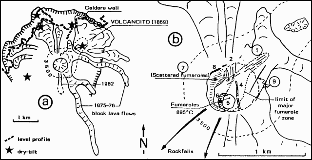 |
Figure 2. Sketch map of the summit of Colima (a) and an expanded view of the summit showing geologic features (b). Courtesy of C. Robin and J.B. Murray |
"Volcancito Cone (~1 km NE of the summit) was visited on 8 February, the summit was climbed for gas and sublimate collection on 11 February, and the volcano was overflown on 14 February. The fractures seen by Dartmouth College geologists in late November (figure 2, number 1) were still the site of fumarolic activity, at an altitude of 3,750 m (all altitudes by altimeter), but the fumarole on Volcancito had ceased to be active.
"The irregular terrain at the summit itself, corresponding to the surface of the andesitic dome, consisted of a narrow plateau at about 3,850 m. The northern slope had shallow N-S fractures 1-3 m across (figure 2, number 2) with sublimate deposits, but no active fumaroles. These fractures were cut by others (figure 2, number 3) trending towards Volcancito (approximately NE). A major N-S zone of weakness, 5-10 m across and very deep with strong fumarolic activity, divided the summit plateau in two (figure 2, number 4). According to volcanologists at the Instituto de Geofísica, Univ Nacional Autónoma de México (UNAM), this zone was already in existence before the 1982 eruption, though perhaps less marked.
"Many summit fumarole temperatures were measured at between 135 and 895°C. The high temperature was found inside a shallow 20-m pit on the SW edge of the summit plateau (figure 2, number 5) perhaps an explosion pit formed in January. A red glow was detectable inside fumaroles even in bright daylight and socks were singed.
"Rockfalls from the summit dome, indicating the continued rise of the central plug, occurred down the W and SW slopes at about 15-20-minute intervals, a rate similar to that noted in December 1982 and March-April 1983. Thirty to 40 m below the summit to the W and NW are the remains of the old crater rim (figure 2, number 8) with a flatter shelf containing scattered fumaroles on its inside edge (figure 2, number 7). On photos taken from the air, two fractures trending NE (figure 2, number 9) are visible crossing the 1975-76 flows SE of the summit, but without noticeable fumarolic activity. The lowest fumarole was found at an altitude of 3,600 m down the NE side of the summit cone and had a temperature of 46°C.
"From the above evidence it seems that the M 8 earthquake in September opened new fractures and accentuated previous ones on the volcano. This may have provoked some depressurization of the near-surface magma, increasing surface temperatures and fumarolic activity, and culminating in the minor ash eruptions of early January. The levelling and dry-tilt data suggest no buildup of magmatic pressure, and the decline in seismic activity since November also indicates that for the moment, there are no portents of a larger eruption such as those that followed the earthquakes of 1611 and 1806."
Geological Summary. The Colima complex is the most prominent volcanic center of the western Mexican Volcanic Belt. It consists of two southward-younging volcanoes, Nevado de Colima (the high point of the complex) on the north and the historically active Volcán de Colima at the south. A group of late-Pleistocene cinder cones is located on the floor of the Colima graben west and east of the complex. Volcán de Colima (also known as Volcán Fuego) is a youthful stratovolcano constructed within a 5-km-wide scarp, breached to the south, that has been the source of large debris avalanches. Major slope failures have occurred repeatedly from both the Nevado and Colima cones, producing thick debris-avalanche deposits on three sides of the complex. Frequent recorded eruptions date back to the 16th century. Occasional major explosive eruptions have destroyed the summit (most recently in 1913) and left a deep, steep-sided crater that was slowly refilled and then overtopped by lava dome growth.
Information Contacts: C. Robin, Lab de Volcanologie, Clermont-Ferrand, France; J.B. Murray, Wheathampstead, UK.