Report on Tacana (Mexico-Guatemala) — April 1986
Scientific Event Alert Network Bulletin, vol. 11, no. 4 (April 1986)
Managing Editor: Lindsay McClelland.
Tacana (Mexico-Guatemala) Earthquake swarm then small phreatic eruption
Please cite this report as:
Global Volcanism Program, 1986. Report on Tacana (Mexico-Guatemala) (McClelland, L., ed.). Scientific Event Alert Network Bulletin, 11:4. Smithsonian Institution. https://doi.org/10.5479/si.GVP.SEAN198604-341130
Tacana
Mexico-Guatemala
15.132°N, 92.109°W; summit elev. 4064 m
All times are local (unless otherwise noted)
A series of shallow earthquakes, many strong enough to be felt near the volcano, began in mid-December and continued through April.
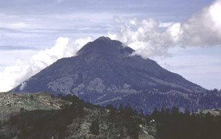
The following is from Servando de la Cruz Reyna. "A volcanic earthquake swarm started in Tacaná volcano on 7 May at 1500. Earthquakes occurred at an average rate of 1/minute, accompanied by thunder-like noises that continued for 23 hours. On 8 May near noon, a moderate phreatic explosion opened a [20-m-diameter] vent that ejected a small amount of fine ash, partially destroying vegetation in an area 200 x 100 m. The vent is located on the upper NE flank (right on the México/Guatemala border) at about 3,800 m altitude [see also 11:09]. The seismic activity continued unchanged through 9 May, then started decreasing on 10 May to a rate of about one earthquake every 5 minutes that has persisted through 11 May. A white plume some 300 m high continued to be emitted as of 11 May. H2S has been qualitatively detected in the plume. No deformation changes have been detected on a bubble tiltmeter located about 1/3 of the way up the S flank. Dry tiltmeter measurements and radon counting are underway. The intensity of the swarm motivated the issuance of an orange alert at three levels (10, 15, and 20 km radius) effective on May 8." Press sources reported that 17,000 people, mostly residents of flank villages, had left their homes.
Geological Summary. Tacaná is a 4064-m-high composite stratovolcano that straddles the México/Guatemala border at the NW end of the Central American volcanic belt. The volcano rises 1800 m above deeply dissected plutonic and metamorphic terrain. Three large calderas breached to the south, and the elongated summit region is dominated by a series of lava domes intruded along a NE-SW trend. Volcanism has migrated to the SW, and a small adventive lava dome is located in the crater of the youngest volcano, San Antonio, on the upper SW flank. Viscous lava flow complexes are found on the north and south flanks, and lobate lahar deposits fill many valleys. Radial drainages on the Guatemalan side are deflected by surrounding mountains into the Pacific coastal plain on the SW side of the volcano. Historical activity has been restricted to mild phreatic eruptions, but more powerful explosive activity, including the production of pyroclastic flows, has occurred as recently as about 1950 years ago.
Information Contacts: S. de la Cruz Reyna, M. Mena, N. Segovia, L. Gonzalez, E. Ramos, A. González, V.H. Espindola, A. Nava, J.M. Espindola, Z. Jimenez, and M.A. Armienta, UNAM, México D.F.; E. Sánchez, INSIVUMEH; AP.