Report on St. Helens (United States) — May 1986

Scientific Event Alert Network Bulletin, vol. 11, no. 5 (May 1986)
Managing Editor: Lindsay McClelland.
St. Helens (United States) Activity returns to background levels
Please cite this report as:
Global Volcanism Program, 1986. Report on St. Helens (United States) (McClelland, L., ed.). Scientific Event Alert Network Bulletin, 11:5. Smithsonian Institution. https://doi.org/10.5479/si.GVP.SEAN198605-321050
St. Helens
United States
46.2°N, 122.18°W; summit elev. 2549 m
All times are local (unless otherwise noted)
During extrusion of a new lobe in early May (SEAN 11:01), the entire dome deformed asymetrically, with maximum movement measured at points on the NE and S sides. A point on the top of the dome just E of the new lobe moved outward horizontally 28 m and subsided 3.2 m between 28 April and 14 May, with most of the change between 8 and 10 May. Another station at the W end of the axis of the 1985 graben moved 21.7 m. More typical displacements on the dome were 4-5 m horizontally. By approximately 28 May, deformation rates had returned to background levels.
During the dome's rapid endogenous growth, the tiltmeter on the N flank of the dome recorded ~15,000 µrads of outward tilt before going off scale on 8 May. The tiltmeter on the N-crater floor recorded ~1,000 µrads of outward tilting from 5 May to midday 8 May when the trend reversed. A large rock avalanche, consisting mainly of newly extruded dacite from the N flank of the dome, destroyed this instrument late on 9 May (figure 32). The N-flank tiltmeter was reset on 14 May and recorded slow outward tilting through 11 June.
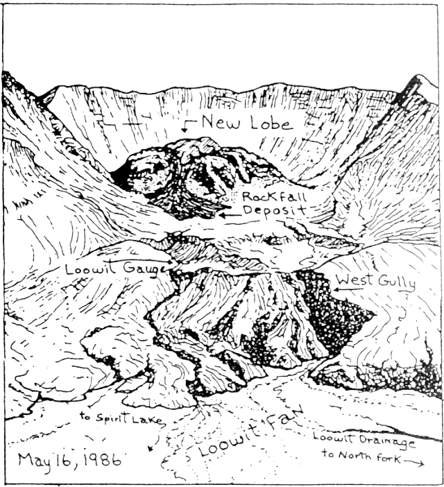 |
Figure 32. Sketch by Bobbie Myers, looking S, showing the new lava lobe extruded in May on top of the dome at Mt. St. Helens and the 9 May rockfall deposits on the crater floor N of the dome. Meltwater generated by the hot rockfall caused a water-rich flow to move out of the crater and down onto the Loowit Fan (SEAN 11:04). |
During peak activity, poor weather conditions limited successful COSPEC flights to 8 May when an SO2 emission rate of 700 t/d was measured. During the next flight, on 14 May, SO2 emissions were down to background levels of 35 plus or minus 5 t/d. In five flights between 14 May and 9 June, an average of 40 plus or minus 5 t/d were measured.
Seismicity also decreased greatly after 10 May and had reached background levels by 20 May (figure 33). The last of the medium- to high-frequency earthquakes, typical of brittle fracture, occurred 17 May. As of 12 June there were a few low-frequency, shallow earthquakes beneath the dome, but the record was dominated by avalanches off the crater wall, associated with summer snowmelt.
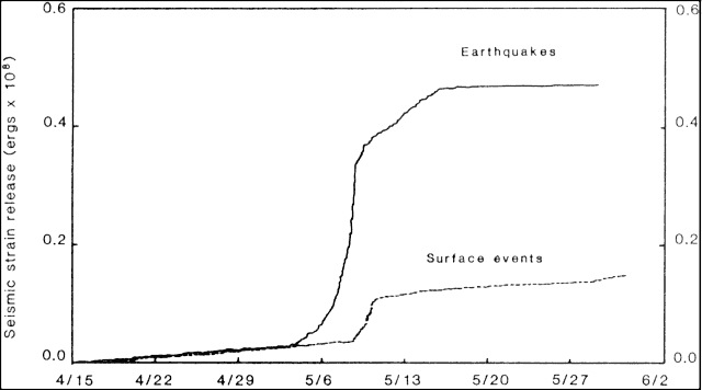 |
Figure 33. Cumulative seismic strain release at Mt. St. Helens, 15 April-30 May. The solid line represents earthquakes and the dashed line surface type events (steam-and-ash emission, avalanches.) |
Geological Summary. Prior to 1980, Mount St. Helens was a conical volcano sometimes known as the Fujisan of America. During the 1980 eruption the upper 400 m of the summit was removed by slope failure, leaving a 2 x 3.5 km breached crater now partially filled by a lava dome. There have been nine major eruptive periods beginning about 40-50,000 years ago, and it has been the most active volcano in the Cascade Range during the Holocene. Prior to 2,200 years ago, tephra, lava domes, and pyroclastic flows were erupted, forming the older edifice, but few lava flows extended beyond the base of the volcano. The modern edifice consists of basaltic as well as andesitic and dacitic products from summit and flank vents. Eruptions in the 19th century originated from the Goat Rocks area on the N flank, and were witnessed by early settlers.
Information Contacts: D. Swanson, D. Dzurisin, J. Sutton, E. Endo, and Bobbie Myers, CVO; C. Jonientz-Trisler, University of Washington.