Report on Izu-Oshima (Japan) — October 1986
Scientific Event Alert Network Bulletin, vol. 11, no. 10 (October 1986)
Managing Editor: Lindsay McClelland.
Izu-Oshima (Japan) Eruption column to 3,200 m after four months of seismicity
Please cite this report as:
Global Volcanism Program, 1986. Report on Izu-Oshima (Japan) (McClelland, L., ed.). Scientific Event Alert Network Bulletin, 11:10. Smithsonian Institution. https://doi.org/10.5479/si.GVP.SEAN198610-284010
Izu-Oshima
Japan
34.724°N, 139.394°E; summit elev. 746 m
All times are local (unless otherwise noted)
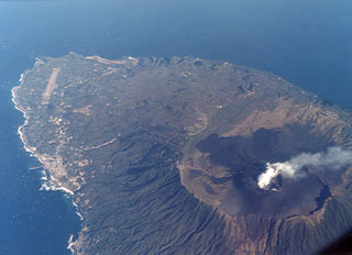
[Preliminary press information in this report is superseded by data from geologists in 11:11]. An eruption from the central crater (Mihara-yama) began the evening of 15 November. An eruption column rose 3200 m above the summit. Small eruptions were continuing the next day, sending ejecta to 500 m. Ash fell over an extensive area. By the morning of 19 November a 5-lobed lava flow had destroyed an observatory tower and Shinto shrine near the crater rim, and was moving down the NW flank at ~1 m/hour. By midday the flow was ~50 m long. "Lava" was ejected to 500 m above the summit and ash rose more than 1.5 km. In the mid-afternoon of 21 November, a 600-m-long fissure opened, extruded lava that flowed toward populated areas, and sent ejecta to about 1,100 m height. Thousands of residents and tourists in 5 communities N and W of the crater were forced to evacuate. Forty forest fires were reported and domestic flights were rerouted to avoid the volcano. Damage to crops was estimated at $1.2 million, but no casualties were reported.
UPI reported that JMA recorded 19 earthquakes with epicenters in the ocean, 10 km from Oshima, on the second day of the eruption. The strongest (4 on the JMA intensity scale of 7) occurred that evening at 1846. AP reported that by 19 November more than 150 submarine events had been recorded. Seventy more recorded earthquakes that began at 1417 on 21 November preceded the fissure opening. One event registered 5 and at least two registered 4 on the JMA intensity scale.
Geological Summary. Izu-Oshima volcano in Sagami Bay, east of the Izu Peninsula, is the northernmost of the Izu Islands. The broad, low stratovolcano forms an 11 x 13 km island constructed over the remnants of three older dissected stratovolcanoes. It is capped by a 4-km-wide caldera with a central cone, Miharayama, that has been the site of numerous recorded eruptions datining back to the 7th century CE. More than 40 cones are located within the caldera and along two parallel rift zones trending NNW-SSE. Although it is a dominantly basaltic volcano, strong explosive activity has occurred at intervals of 100-150 years throughout the past few thousand years. A major eruption in 1986 produced spectacular lava fountains up to 1,600 m high and a 16-km-high eruption column; more than 12,000 people were evacuated from the island.
Information Contacts: UPI; AP.