Report on Fuss Peak (Russia) — April 1987
Scientific Event Alert Network Bulletin, vol. 12, no. 4 (April 1987)
Managing Editor: Lindsay McClelland.
Fuss Peak (Russia) Moderate fumarolic activity
Please cite this report as:
Global Volcanism Program, 1987. Report on Fuss Peak (Russia) (McClelland, L., ed.). Scientific Event Alert Network Bulletin, 12:4. Smithsonian Institution. https://doi.org/10.5479/si.GVP.SEAN198704-290340
Fuss Peak
Russia
50.267°N, 155.246°E; summit elev. 1742 m
All times are local (unless otherwise noted)
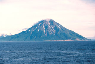
Between 12 October and 2 November 1986, moderate fumarolic activity was observed in the E part of the summit crater. The fumaroles fell along a N-S line that divided the crater. The rest of the crater was snow-covered.
Geological Summary. Fuss Peak in the northern Kuriles forms a peninsula that lies across a low isthmus on the SW coast of Paramushir Island. The volcano rises 2800 m from the floor of the Sea of Okhotsk to a height of 1742 m. This isolated symmetrical andesitic stratovolcano has a 700-m-wide, steep-walled crater that is 300 m deep. A deep notch cuts the NW rim of the crater to the level of the crater floor, at the head of a canyon that reaches the coast. Well-preserved lava flows occupy the middle and lower flanks, particularly on the E and SE sides. Only one unambiguous historical eruption, in 1854, is known. Reports of eruptions in 1737, 1793, 1857, and 1859 are false (Gorshkov, 1970). Murayama (1987) also listed an eruption in 1742 (only earthquakes and a tsunami are cited by Sapper, 1917) and "smoke" emission in 1933.
Information Contacts: G. Steinberg and B. Piskunov, Yuzhno-Sakhalinsk.