Report on Tacana (Mexico-Guatemala) — August 1987
Scientific Event Alert Network Bulletin, vol. 12, no. 8 (August 1987)
Managing Editor: Lindsay McClelland.
Tacana (Mexico-Guatemala) Fewer microearthquakes
Please cite this report as:
Global Volcanism Program, 1987. Report on Tacana (Mexico-Guatemala) (McClelland, L., ed.). Scientific Event Alert Network Bulletin, 12:8. Smithsonian Institution. https://doi.org/10.5479/si.GVP.SEAN198708-341130
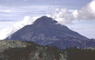
Tacana
Mexico-Guatemala
15.132°N, 92.109°W; summit elev. 4064 m
All times are local (unless otherwise noted)
During July, the SBG seismic station registered 20 microearthquakes with S-P <= 2.0 seconds. There have been no recent reports about the state of the vent formed by the 8 May 1986 phreatic eruption.
Geological Summary. Tacaná is a 4064-m-high composite stratovolcano that straddles the México/Guatemala border at the NW end of the Central American volcanic belt. The volcano rises 1800 m above deeply dissected plutonic and metamorphic terrain. Three large calderas breached to the south, and the elongated summit region is dominated by a series of lava domes intruded along a NE-SW trend. Volcanism has migrated to the SW, and a small adventive lava dome is located in the crater of the youngest volcano, San Antonio, on the upper SW flank. Viscous lava flow complexes are found on the north and south flanks, and lobate lahar deposits fill many valleys. Radial drainages on the Guatemalan side are deflected by surrounding mountains into the Pacific coastal plain on the SW side of the volcano. Historical activity has been restricted to mild phreatic eruptions, but more powerful explosive activity, including the production of pyroclastic flows, has occurred as recently as about 1950 years ago.
Information Contacts: E. Sánchez, INSIVUMEH.