Report on Izu-Oshima (Japan) — January 1988
Scientific Event Alert Network Bulletin, vol. 13, no. 1 (January 1988)
Managing Editor: Lindsay McClelland.
Izu-Oshima (Japan) Ash emission; more crater wall collapse
Please cite this report as:
Global Volcanism Program, 1988. Report on Izu-Oshima (Japan) (McClelland, L., ed.). Scientific Event Alert Network Bulletin, 13:1. Smithsonian Institution. https://doi.org/10.5479/si.GVP.SEAN198801-284010
Izu-Oshima
Japan
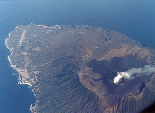
34.724°N, 139.394°E; summit elev. 746 m
All times are local (unless otherwise noted)
The number of earthquakes dropped to a low level after 24 November under both the summit crater (~10/day) and the E part of the island. Volcanic tremor below the summit crater ceased after an 18 November eruption, but resumed intermittently on 18 December and became continuous from 18 January. The amplitude of each tremor episode was small at first, but began increasing the evening of 5 January. The duration of each episode was several tens of minutes.
Crater floor subsidence of 175 m was associated with the November activity but the only change in summit area topography (noted during a helicopter survey on 5 January) was some further collapse of the crater wall.
Small eruptions on 25 January at 1530 and 27 January at 1425 ejected ash clouds to 300-400 m above the summit crater. Each lasted only a few minutes and they were not accompanied by air shocks or explosion sounds. Light ashfall occurred on the E side of the island. Tiltmeters detected no noticeable deformation associated with the eruptions. At other times, a white steam plume rose continuously to about 300-800 m above the crater. A 1,000-m white plume was noted on 27 January at 0900.
Geological Summary. Izu-Oshima volcano in Sagami Bay, east of the Izu Peninsula, is the northernmost of the Izu Islands. The broad, low stratovolcano forms an 11 x 13 km island constructed over the remnants of three older dissected stratovolcanoes. It is capped by a 4-km-wide caldera with a central cone, Miharayama, that has been the site of numerous recorded eruptions datining back to the 7th century CE. More than 40 cones are located within the caldera and along two parallel rift zones trending NNW-SSE. Although it is a dominantly basaltic volcano, strong explosive activity has occurred at intervals of 100-150 years throughout the past few thousand years. A major eruption in 1986 produced spectacular lava fountains up to 1,600 m high and a 16-km-high eruption column; more than 12,000 people were evacuated from the island.
Information Contacts: JMA; Kyodo radio, Tokyo.