Report on Akutan (United States) — May 1988
Scientific Event Alert Network Bulletin, vol. 13, no. 5 (May 1988)
Managing Editor: Lindsay McClelland.
Akutan (United States) Small tephra eruptions resume
Please cite this report as:
Global Volcanism Program, 1988. Report on Akutan (United States) (McClelland, L., ed.). Scientific Event Alert Network Bulletin, 13:5. Smithsonian Institution. https://doi.org/10.5479/si.GVP.SEAN198805-311320
Akutan
United States
54.134°N, 165.986°W; summit elev. 1303 m
All times are local (unless otherwise noted)
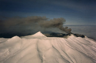
During a 5 May overflight, Marsha Brown (FAA, Cold Bay) noted fairly extensive, fresh-looking, black ash deposits on Akutan's flanks. No additional activity was reported until the onset of several days of small tephra eruptions on 31 May, summarized in table 3. Peninsula Airways pilot Nick Sias, who passes over Akutan regularly, notes that he has not seen any incandescent ejecta since the activity began.
Table 3. Reports of activity at Akutan, 31 May-2 July 1988, complied by John Reeder from the following observers (initials in brackets): David, Charles, and June McGlashin, Charlotte Jones, and Richard Petre, (Akutan village); Nick Sias, William Redmond, Buddy Burnett, Rick Wilbur, Charles Rodehaver, Brian Carricaburu, and Dan Johnson, Peninsula Airways; Abi Dickson, Unalaska; Jean Robert, Clint Schoenleber, Terry Reece, Jerry Friz, MarkAir; Floyd Saltz, pilot, Anchorage; Tom Madsen, Aleutian Air; Steve Felch, Northern Air Cargo; and a member of the United States Coast Guard (USCG). All heights reported as meters above the summit.
| Date | Time | Activity [with observers] |
| 31 May 1988 | 1319 | Shock wave rattled a building in Akutan village, 12.5 km E of the volcano [DM, CM]. Very black tephra plume (1,800 m within about a minute) blown rapidly SSE by 60 km/hour winds as it continued to rise. Muffled explosion sound heard in the village {RP]. No other eruptions observed that day. |
| 01 Jun 1988 | 0854 | Gray steam and ash plume (1,700 m in just over a minute) [RP]. |
| 01 Jun 1988 | 0855 | Gray ash (1,800 m) [RP]. |
| 01 Jun 1988 | 0856 | Darker, rapidly rising column [RP]. |
| 01 Jun 1988 | 0858 | Small gray plume [RP]. |
| 01 Jun 1988 | 0859 | Small gray steam-and-ash cloud [RP]. The three largest plumes reached estimated altitudes of 3,000, 3,350, and 3,600 m [JM]. |
| 01 Jun 1988 | 0920 | Darker, mushroom-like cloud (2,000-2,400 m in just over a minute) [RP]. |
| 01 Jun 1988 | 1024 | Dark ash deposit extended to the volcano's ESE base [NS]. |
| 01 Jun 1988 | 1129 | Dark plume (1,800 m) [RP]. |
| 01 Jun 1988 | 1147 | Lighter plume (1,200-1,500 m) [RP]. |
| 01 Jun 1988 | 1342 | Brown and dark gray cloud (1,800 m) ejected for 13 minutes [RP]. |
| 01 Jun 1988 | 1517 | Similar plume, 6 minutes [RP]. |
| 01 Jun 1988 | 1614 | Similar plume (2,100-2,400 m), 4 minutes [RP]. |
| 01 Jun 1988 | 1649 | Darker plume (1,500-1,800 m), 9 minutes [RP]. |
| 01 Jun 1988 | 1913 | Lighter brown-gray plume (1,500 m), 5 min [RP]. |
| 01 Jun 1988 | 2042 | Darker brown cloud (1,800 m), 4.5 minutes [RP]. Each of the 1 June eruptions was followed by several minutes of steam emission. |
| 02 Jun 1988 | 0919 | Large plume (2,700 m, no wind [RP], 3,660 m altitude [WR]), 13 minutes. |
| 02 Jun 1988 | 1034 | Brown plume (1,500 m [RP]), with individual blocks visible from the air 1 km away [NS]. |
| 02 Jun 1988 | 1150 | Plume had reached 3,000 m altitude [JR]. |
| 02 Jun 1988 | around 1245 | Ash emitted at about 10-minute intervals, drifting S at 2,700 m altitude [JR]. |
| 02 Jun 1988 | 1305 | Plume 9-15 km wide at 4,000 m altitude, 55 km SE of the volcano [BB]. |
| 02 Jun 1988 | 1312 | Steam and ash (150 m) [FS]. |
| 02 Jun 1988 | 1413 | Ash at 2,900 m altitude, moving SE [BB]. |
| 02 Jun 1988 | 1501 | Narrow, dark gray plume, 3.5-4 minutes, then stronger black burst (2,500 m), dark gray ash until 1516 [RP]. |
| 02 Jun 1988 | 1632 | Plume drifting NW [RW]. Weather conditions prevented further observations from Akutan village. |
| 02 Jun 1988 | 1833 | Dark gray to black plume through 1850 [AD]. |
| 02 Jun 1988 | 1900 | Same plume, at 4,100 m altitude, had extended 30 km SE [FS, TM]. |
| 02 Jun 1988 | after 1900 | Another large plume, NW of Akutan at 4,100 m altitude by 1950 [FS, TM]. |
| 02 Jun 1988 | 2050 | Continuous eruption through 2110, plume to 2,300 m altitude, moving NE [TM]. |
| 03 Jun 1988 | -- | Heavy weather clouds obscured the volcano. |
| 04 Jun 1988 | 1100 | Large dark cloud that contained blocks (4 minutes) [NS]. |
| 04 Jun 1988 | 1303 | Small dark gray plume (less than 600 m), drifted W [AD]. Despite numerous observations, no further activity was observed until 6 June. |
| 06 Jun 1988 | 1115 | Minor ash emission from the summit cinder cone (100 m) [DJ]. |
Geological Summary. Akutan contains a 2-km-wide caldera with a large cinder cone in the NE part of the caldera that has been the source of frequent explosive eruptions and occasional lava effusion that covers the caldera floor. An older, largely buried caldera was formed during the late Pleistocene or early Holocene. Two volcanic centers are located on the NW flank. Lava Peak is of Pleistocene age, and a cinder cone lower on the flank produced a lava flow in 1852 that extended the shoreline of the island and forms Lava Point. The 60-365 m deep younger caldera was formed during a major explosive eruption about 1,600 years ago and contains at least three lakes. A lava flow in 1978 traveled through a narrow breach in the north caldera rim almost to the coast. Fumaroles occur at the base of the caldera cinder cone, and hot springs are located NE of the caldera at the head of Hot Springs Bay valley and along the shores of Hot Springs Bay.
Information Contacts: J. Reeder, ADGGS.