Report on Fernandina (Ecuador) — August 1988
Scientific Event Alert Network Bulletin, vol. 13, no. 8 (August 1988)
Managing Editor: Lindsay McClelland.
Fernandina (Ecuador) Eruption cloud extends 300 km
Please cite this report as:
Global Volcanism Program, 1988. Report on Fernandina (Ecuador) (McClelland, L., ed.). Scientific Event Alert Network Bulletin, 13:8. Smithsonian Institution. https://doi.org/10.5479/si.GVP.SEAN198808-353010
Fernandina
Ecuador
0.37°S, 91.55°W; summit elev. 1476 m
All times are local (unless otherwise noted)
On 14 September an eruption of Fernandina ended the longest period of volcanic quiet in the Galápagos Islands in the last 20 years. Fernandina's last eruption was in March/April 1984 (9:3), and no eruptions have been reported from the Galápagos since then.
An unusual earthquake swarm was recorded by the WWSSN on 24 February 1988, and the most recent hypocenter locations (USGS Monthly Listing) place six events within 25 km of Fernandina's caldera. These took place within a 10-hour period and were in the mb range 5.0-5.5. Two more recent earthquakes have also been located within 25 km of Fernandina's caldera, an mb 4.8 event on 15 April and a 5.3 event on 20 May (USGS PDEs 16-88 and 21-88). Inquiries following the 24 February swarm revealed no observations of volcanism by scientists, residents, or tour vessel personnel in Galápagos, but Fernandina is uninhabited and cannot be seen from inhabited parts of the archipelago. Inspection of low-resolution satellite imagery found no Galápagos plumes on 24 February.
On 14 September, residents of southern Isla Isabela felt earthquakes around 1100, and around 1130 a National Park warden on one of the Isabela volcanoes saw an eruption cloud from Fernandina's caldera, roughly 60 km to the NW. Alfredo Carrasco confirmed the 1100 seismicity by inspecting the Darwin Station seismograms, but no other reports from the islands were available at press time. A group including National Park and Darwin Station personnel left Isla Santa Cruz for Fernandina on 15 September [13:10].
Inspection of NOAA geostationary satellite images by Otto Karst found no plume on an image returned at 1115, but a small, point-source cloud over western Fernandina at 1230. By 1830 the plume had spread 220 km SW and very preliminary inspection of infrared data suggested an altitude of 9 km for the cloud. The plume had started to separate from its source 2.5 hours later, indicating an end to the eruption, and by 0030 on 15 September the cloud was fully dispersed and no longer visible on the image. The path of the TOMS instrument on the Nimbus-7 polar orbiting satellite was not well placed for measuring the cloud on 14 September. However, preliminary TOMS data collected at about noon on 15 September showed a plume of SO2 extending ~ 300 km WNW from the vicinity of the island [see also 13:10].
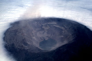
Geological Summary. Fernandina, the most active of Galápagos volcanoes and the one closest to the Galápagos mantle plume, is a basaltic shield volcano with a deep 5 x 6.5 km summit caldera. The volcano displays the classic "overturned soup bowl" profile of Galápagos shield volcanoes. Its caldera is elongated in a NW-SE direction and formed during several episodes of collapse. Circumferential fissures surround the caldera and were instrumental in growth of the volcano. Reporting has been poor in this uninhabited western end of the archipelago, and even a 1981 eruption was not witnessed at the time. In 1968 the caldera floor dropped 350 m following a major explosive eruption. Subsequent eruptions, mostly from vents located on or near the caldera boundary faults, have produced lava flows inside the caldera as well as those in 1995 that reached the coast from a SW-flank vent. Collapse of a nearly 1 km3 section of the east caldera wall during an eruption in 1988 produced a debris-avalanche deposit that covered much of the caldera floor and absorbed the caldera lake.
Information Contacts: G. Reck and A. Carrasco, Charles Darwin Research Station; L. Maldonado, Metropolitan Touring, Quito; B. Presgrave, NEIC; M. Matson and O. Karst, NOAA/NESDIS; A. Krueger,GSFC.

