Report on Akutan (United States) — April 1989
Scientific Event Alert Network Bulletin, vol. 14, no. 4 (April 1989)
Managing Editor: Lindsay McClelland.
Akutan (United States) Small ash ejections resume
Please cite this report as:
Global Volcanism Program, 1989. Report on Akutan (United States) (McClelland, L., ed.). Scientific Event Alert Network Bulletin, 14:4. Smithsonian Institution. https://doi.org/10.5479/si.GVP.SEAN198904-311320
Akutan
United States
54.134°N, 165.986°W; summit elev. 1303 m
All times are local (unless otherwise noted)
Small ash ejections resumed in February 1989. Observer's initials, in brackets, follow their information in the chronology below.
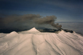
27 February, 1200: A small, short-lived, vertical blast of ash and steam from the summit tephra cone was observed from a small boat on the N side of Akutan Island. The plume was probably <500 m high [LP].
15 March: An atmospheric shock wave was felt at 0900 by a pilot [NS] over the W shore of Akutan volcano. A black summit eruption plume rose rapidly, its top disappearing into cloud cover at 1,800 m altitude. Near Akutan village, the plume was observed at 0900 [RP] through a break in the clouds. Black ash quickly reached an estimated 2,300 m above the volcano. During the next several hours, emissions diminished and turned gray, with only a small white steam plume evident just before noon. At 1430, a small dark-gray eruption plume was observed from the village, drifting S [DM]. During an overflight at 1500, the summit tephra cone emitted dark steam [NS and HW]. Observations of the W and SW flanks revealed fresh ash covering the snow above 600 m elevation.
16 March, morning: A very light dusting of ash that had fallen the previous night was noticed in Akutan village [DM]. At 1100 the volcano's summit region was white with fresh snow [HW].
Between 17 and 31 March: A crater on the E side of the summit cone began to emit steam at some time during this period [DM]. Previously, steam had emerged only from the cone's W side.
28-29 March: Akutan's summit was black with fresh-looking ash. Minor amounts of steam were emitted [CL].
31 March, about 1945: A large white plume was observed at least 600 m above Akutan from a U.S. Coast Guard plane [SR]. The plume top had drifted 7 km S. No eruptive activity had been seen from near the village at 1900 [LL]. No further activity was observed from 31 March until the end of the report period on 7 April.
Observers (initials in brackets): Lawrence Prokopioff, Richard Petre, David McGlashan, Harold Wilson, and Linda Logan, Akutan Village and vicinity; Nick Sias, Peninsula Airways; Craig Leth, FAA; Lieutenant Commander Steve Rapalus and his crew, U.S. Coast Guard.
Geological Summary. Akutan contains a 2-km-wide caldera with a large cinder cone in the NE part of the caldera that has been the source of frequent explosive eruptions and occasional lava effusion that covers the caldera floor. An older, largely buried caldera was formed during the late Pleistocene or early Holocene. Two volcanic centers are located on the NW flank. Lava Peak is of Pleistocene age, and a cinder cone lower on the flank produced a lava flow in 1852 that extended the shoreline of the island and forms Lava Point. The 60-365 m deep younger caldera was formed during a major explosive eruption about 1,600 years ago and contains at least three lakes. A lava flow in 1978 traveled through a narrow breach in the north caldera rim almost to the coast. Fumaroles occur at the base of the caldera cinder cone, and hot springs are located NE of the caldera at the head of Hot Springs Bay valley and along the shores of Hot Springs Bay.
Information Contacts: J. Reeder, ADGGS.