Report on Izu-Tobu (Japan) — June 1989
Scientific Event Alert Network Bulletin, vol. 14, no. 6 (June 1989)
Managing Editor: Lindsay McClelland.
Izu-Tobu (Japan) Brief eruption follows two-week seismic swarm
Please cite this report as:
Global Volcanism Program, 1989. Report on Izu-Tobu (Japan) (McClelland, L., ed.). Scientific Event Alert Network Bulletin, 14:6. Smithsonian Institution. https://doi.org/10.5479/si.GVP.SEAN198906-283010
Izu-Tobu
Japan
34.9°N, 139.098°E; summit elev. 1406 m
All times are local (unless otherwise noted)
After a 2-week earthquake swarm, a brief submarine eruption built a small cone on the sea bottom a few kilometers off the coast of the Izu Peninsula. [See 14:7 for a more detailed report from JMA.]
Earthquakes began 30 June, and by 9 July, more than 19,000 had been recorded. Many were at depths of 4-5 km in a zone roughly 3-7 km NE of Ito, a city of 72,000 about 100 km SW of Tokyo and 40 km NW of Oshima volcano. The swarm included a pair of strong events that occurred within a minute of each other on 9 July at 1109; the first was of M 5.5, the second slightly weaker. At least 18 people were injured by these shocks, and landslides were reported at 16 sites. A year earlier, more than 17,000 events centered farther from the coast were recorded during a month of seismicity that began in late July 1988. Previous swarms had occurred SE of the 1989 epicentral area in 1984 and 1985, and numerous other 1984-86 events occurred in a zone separating the 1984 and 1985 swarm epicenters.
The eruption began on 13 July. A JMA seismometer started to record microseismicity at 1829. The captain of the RV Takuyo (Hydrographic Dept, JMSA), carrying out a bathymetric survey in the area, reported hearing an explosion sound from the sea bottom and a 30-second vibration at 1833. One minute later, the JMA seismometer was saturated by seismic events and remained saturated for the next 10 minutes or more. At 1840, the crew of the RV Takuyo saw the sea surface dome upward about 500 m from the vessel, then a gray-black plume rose from the same area. Five more plumes, ~30 m high and 100 m across, were observed in the next 5 minutes. The ejection of each plume was accompanied by violent shaking and vibration of the ship. No more eruptive activity was reported. Seismographs were again saturated at 1902, and another seismic sequence, of different frequency, was recorded at 1907. Another 15 minutes of volcanic microseismicity began at 2130. No detailed reports were available for the next few days, but strong seismicity stopped after 16 July.
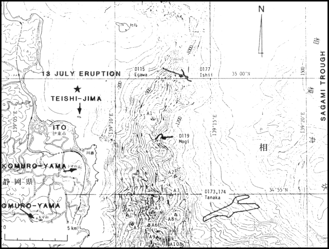
After the eruption, a bathymetric survey using an unmanned vessel detected a new cone in about 100 m of water at the eruption site. The cone was about 450 m wide, with a summit crater 200 m in diameter, but rose only ~10 m above the sea bottom. The eruption occurred in a region of Recent monogenetic volcanism that has built numerous subaerial and submarine cones (figure 1). One nearby pyroclastic flow (Kawagodiara) on the Izu Peninsula has been dated at about 3,250 BP. No ages are available for the submarine edifices, although very fresh pillow lavas were found downslope during work in a submersible.
Reference. Ishii, T., Watanabe, M., Ishizuka, T., Ohta, S., Sakai, H., Haramura, H., Shikazono, N., Togashi, K., Minai, Y., Tominaga, T., Chinzei, K., Horikoshi, M., and Matsumoto, E., 1988, Geological Study with the "Shinkai 2000" in the West Sagami Bay including Calyptogena Colonies; Technical Reports of the Japan Marine Science and Technology Center, 1988, p. 189-218.
Geological Summary. The Izu-Tobu volcano group (Higashi-Izu volcano group) is scattered over a broad, plateau-like area of more than 400 km2 on the E side of the Izu Peninsula. Construction of several stratovolcanoes continued throughout much of the Pleistocene and overlapped with growth of smaller monogenetic volcanoes beginning about 300,000 years ago. About 70 subaerial monogenetic volcanoes formed during the last 140,000 years, and chemically similar submarine cones are located offshore. These volcanoes are located on a basement of late-Tertiary volcanic rocks and related sediments and on the flanks of three Quaternary stratovolcanoes: Amagi, Tenshi, and Usami. Some eruptive vents are controlled by fissure systems trending NW-SE or NE-SW. Thirteen eruptive episodes have been documented during the past 32,000 years. Kawagodaira maar produced pyroclastic flows during the largest Holocene eruption about 3,000 years ago. The latest eruption occurred in 1989, when a small submarine crater was formed NE of Ito City.
Information Contacts: T. Ishii, SI; S. Aramaki, Earthquake Research Institute, Univ of Tokyo; JMA; Hydrographic Dept, JMSA; Asahi Shinbun News, Tokyo.


