Report on Izu-Tobu (Japan) — July 1989
Scientific Event Alert Network Bulletin, vol. 14, no. 7 (July 1989)
Managing Editor: Lindsay McClelland.
Izu-Tobu (Japan) Submarine cone growth documented; seismicity declines
Please cite this report as:
Global Volcanism Program, 1989. Report on Izu-Tobu (Japan) (McClelland, L., ed.). Scientific Event Alert Network Bulletin, 14:7. Smithsonian Institution. https://doi.org/10.5479/si.GVP.SEAN198907-283010
Izu-Tobu
Japan
34.9°N, 139.098°E; summit elev. 1406 m
All times are local (unless otherwise noted)
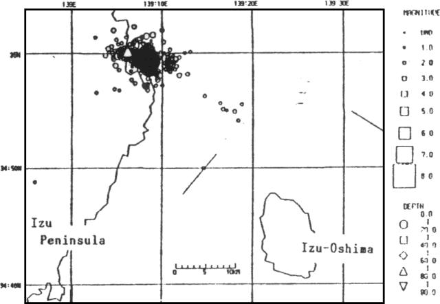
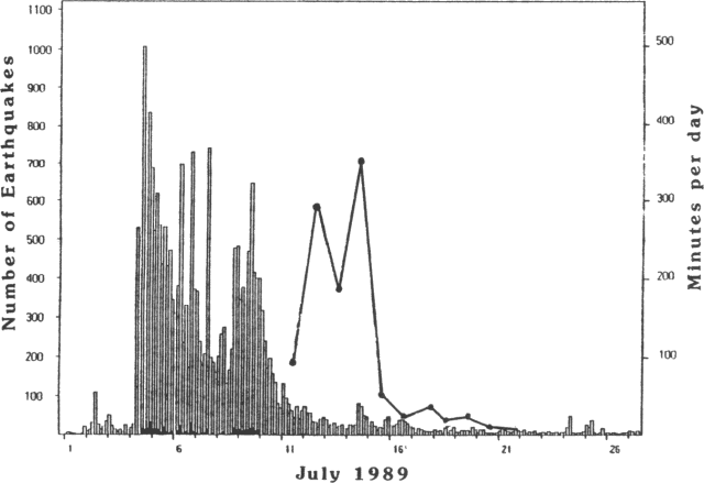
The following supplements preliminary information in 14:6. An earthquake swarm began on 30 June beneath the sea floor E of the Izu Peninsula, an area where swarms have occurred roughly once or twice a year since 1976 (figure 2). The shocks were centered on the NE side of the post-1976 epicentral zone and were shallower than those of previous swarms (figure 3). Seismicity increased sharply on 4 July (figure 4). The strongest event, M 5.5 on 9 July at 1109, reached intensity 5 (JMA scale) in the Ito area and 4 near Ajiro, and had a right-lateral focal mechanism. The number of earthquakes began to decline the next day. However, strong ground tremor, initially with continuous wave trains of varying amplitude, then almost completely saturating instruments, was recorded 11 July between 2038 and 2148 (figure 5). Strong rumbling sounds accompanied the 11 July tremor but no eruption was evident on the sea surface. Another episode of vigorous ground tremor, with sporadic amplitude increases, began about midnight 12/13 July. The explosions observed from the JMSA's RV Takuyo between 1840 and 1845 (14:06) began with updoming of the sea surface, followed by cockscomb ejections. Frequent, audible shock waves jolted the vessel, 0.5 km from the eruption site. Strong, continuous tremor between 1833 and 1917 nearly saturated local seismometers (figure 6). Small tremor episodes continued until 20 July, with the longest total tremor duration on the 14th. Although bubbling was seen at the the eruption site and other locations nearby, no further eruptions were detected at the surface.
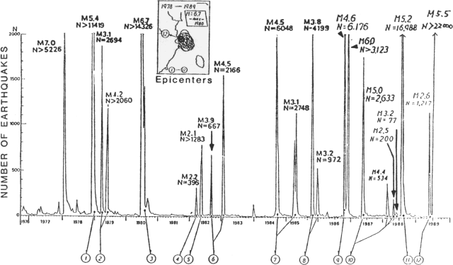 |
Figure 2. Seismic activity NE of the Izu Peninsula, 1976-89. Inset box shows superimposed epicentral zones of each of the 12 swarms, with the July 1989 swarm (no. 12) highlighted. Courtesy of JMA. |
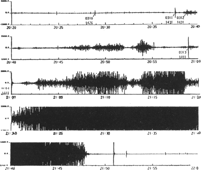 |
Figure 5. Seismograph record, 11 July between 2020 and 2200, showing tremor onset about 2038 and eventual saturation of instruments before tremor ended about 2148. Courtesy of JMA. |
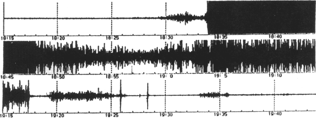 |
Figure 6. Seismograph record, 13 July between 1815 and 1945, including the period of eruptions visible at the sea surface. Courtesy of JMA. |
JMSA bathymetric surveys of the eventual eruption site recorded a flat sea floor before 9 July, but by 13 July, just before the witnessed explosions, the same area had developed a feature ~20 m high and 250 m across at its base. Most volcanologists believed that this feature had grown from submarine eruptions that were not witnessed but probably accompanied the strong tremor of 11 and/or 12 July. A 15 July resurvey revealed an edifice only 10 m high but 450 m in basal diameter, with a crater 200 m across breached on its south side (figure 7). Bubbles rose ~90 m from the crater to the sea surface.
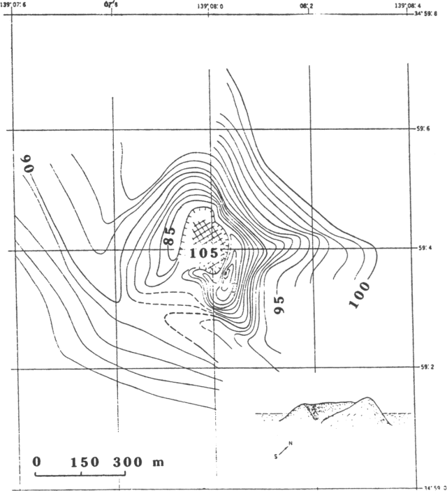 |
Figure 7. Bathymetry of Teishi-Kaikyu measured by an unmanned JMSA survey vessel, 15 July. Contour interval is 1 m. A sketch of the cone is inset at lower right. Courtesy of JMSA. |
Analysis by the National Research Center for Disaster Prevention revealed that the eruption was preceded by large, apparently precursory, ground tilting ~2.5 km to the SSE. Uplift centered in the Ito area was detected by Geographical Survey Institute levelling surveys, but was generally considered to be a possible precursor to stronger tectonic seismicity. The eruption site lies almost directly between Ito City and Hatsushima Island (roughly 10 km apart), and EDM data from the Earthquake Research Institute, Univ of Tokyo, show a clear increase in the distance between them. However, geologists suspect that the distance change may have been caused by faulting associated with the M 5.5 earthquake on 9 July rather than intrusion of magma.
Further References. Okada, Y., and Yamamoto, E., 1991, Dyke intrusion model for the 1989 seismo-volcanic activity off Ito, central Japan: JGR.
Shimada, S., Fujinawa, Y., Sekiguchi, S., Ohmi, S., Eguchi, T., and Okada, Y., 1990, Detection of a volcanic fracture opening in Japan using global positioning system measurements: Nature, v. 343, p. 631-633.
Geological Summary. The Izu-Tobu volcano group (Higashi-Izu volcano group) is scattered over a broad, plateau-like area of more than 400 km2 on the E side of the Izu Peninsula. Construction of several stratovolcanoes continued throughout much of the Pleistocene and overlapped with growth of smaller monogenetic volcanoes beginning about 300,000 years ago. About 70 subaerial monogenetic volcanoes formed during the last 140,000 years, and chemically similar submarine cones are located offshore. These volcanoes are located on a basement of late-Tertiary volcanic rocks and related sediments and on the flanks of three Quaternary stratovolcanoes: Amagi, Tenshi, and Usami. Some eruptive vents are controlled by fissure systems trending NW-SE or NE-SW. Thirteen eruptive episodes have been documented during the past 32,000 years. Kawagodaira maar produced pyroclastic flows during the largest Holocene eruption about 3,000 years ago. The latest eruption occurred in 1989, when a small submarine crater was formed NE of Ito City.
Information Contacts: JMA.

