Report on Santa Maria (Guatemala) — July 1989

Scientific Event Alert Network Bulletin, vol. 14, no. 7 (July 1989)
Managing Editor: Lindsay McClelland.
Santa Maria (Guatemala) Details of 19 July explosion
Please cite this report as:
Global Volcanism Program, 1989. Report on Santa Maria (Guatemala) (McClelland, L., ed.). Scientific Event Alert Network Bulletin, 14:7. Smithsonian Institution. https://doi.org/10.5479/si.GVP.SEAN198907-342030
Santa Maria
Guatemala
14.757°N, 91.552°W; summit elev. 3745 m
All times are local (unless otherwise noted)
The following supplements the preliminary report in BGVN 14:06.
"On 19 July, 32 Central American volcanologists were completing a field hazard mapping project, part of a training course sponsored by the Centro de Coordinación para la Prevención de Desastres Naturales en America Central (funded by the government of Sweden). The course prepared volcanic hazard reports and maps for Cerro Quemado, Guatemala, but on 19 July participants were touring the area near El Palmar (12 km SSW of Santiaguito) to view deposits and damage caused by river aggradation associated with continual activity at Santiaguito since 1973.
"At 0915, during excellent viewing conditions, the group observed a spectacular vertical explosive eruption and pyroclastic flow from Santiaguito (figure 11). The vertical explosion and pyroclastic flow occurred simultaneously, apparently associated with a minor (?) collapse of part of the dome near Caliente Vent. The ash cloud rose about 4 km above the vent, and was clearly observed from Llano del Piñal, 6 km NNE. Ashfall occurred in the areas W and SW of the volcano. The maximum measured thickness was 1 cm at Finca Monte Bello (6 km WSW), but ash fell at least as far away as the Mexican border (65 km distant). The pyroclastic flow followed the same path as recent lava flows from Caliente Vent, descending into the valley of the Río Nimá II and forming a block-and-ash flow and ash cloud surge that mantled some of the 1987-89 lava flow. The main part of the pyroclastic flow traveled 5 km, about 1 km farther downstream than the April 1973 pyroclastic flow (figure 20; Rose, 1973; and Rose et al., 1976/7), and thus probably represents the largest since the 1929-34 activity (Sapper and Termer, 1930; Termer, 1934; and Reck and von Tuerckheim, 1935). Some of the ash cloud surge from the pyroclastic flow probably traveled a shorter distance eastward, based on distant observations of burned vegetation. The composition of hot blocks in the new block and ash flow deposit, collected on the afternoon of 19 July is dacite (64% SiO2), identical to other recent samples and nearly all of the dome rocks extruded since 1922.
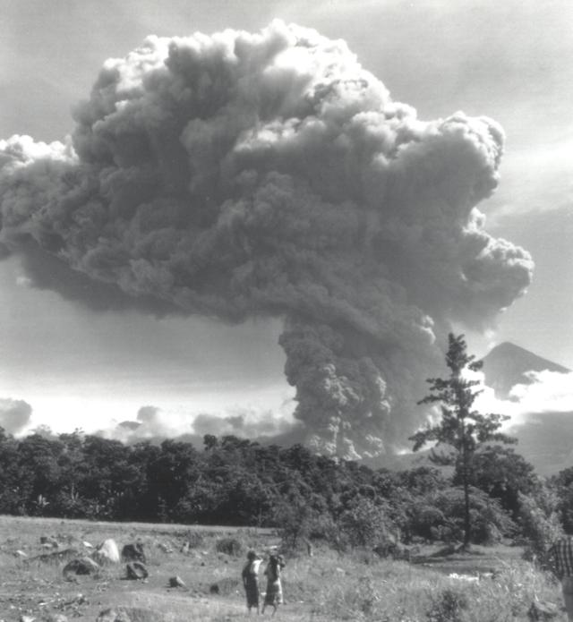 |
Figure 11. Photograph of Santiaguito's eruption column on 19 July 1989 at about 0920, looking N from the valley of the Río Nimá II just W of El Palmar, Guatemala. The tephra cloud and pyroclastic flow are shown about 5 minutes after onset of the eruption. Santa María volcano, in the right background, has a summit elevation of about 3,700 m. Courtesy of Mike Conway. |
"Visibility was lost within 2 hours after the eruption. A much smaller vertical explosion occurred about 20 minutes after the first, followed by two smaller phreatomagmatic eruptions before 1000. A small vertical eruption was also observed at about 1615." [see also Atmospheric Effects, BGVN 14:8-11].
References. Reck, H., and von Tuerckheim, O.G., 1935, Die Zustand der Vulkane Fuego, Atitlán, und Santa María in Guatemala Ende 1934: Zeitschrift für Vulkanologie, v. 16, p. 259-263.
Rose, W.I., 1973, Nuée ardente from Santiaguito volcano, April 1973: Bull Volc, v. 37, p. 365-371.
Rose, W.I., Pearson, T., and Bonis, S., 1976/77, Nuée ardente eruption from the foot of a dacite lava flow, Santiaguito volcano, Guatemala: Bull Volc, v. 40, p. 23-38.
Rose, W.I., 1987, Volcanic activity at Santiaguito volcano, 1976-1984 in Fink, J., ed., The emplacement of silicic domes and lava flows: GSA Special Paper 212, p. 17-27.
Sapper, K., and Termer, F., 1930, The eruption of Santa María volcano in Guatemala of November 24, 1929: Zeitschrift für Vulkanologie, v. 13, p. 73-101.
Termer, F., 1934, Die Tätigkeit des Vulkans Santa María in Guatemala in den Jahren 1931-1933: Zeitschrift für Vulkanologie, v. 14, p. 43-50.
Geological Summary. Symmetrical, forest-covered Santa María volcano is part of a chain of large stratovolcanoes that rise above the Pacific coastal plain of Guatemala. The sharp-topped, conical profile is cut on the SW flank by a 1.5-km-wide crater. The oval-shaped crater extends from just below the summit to the lower flank, and was formed during a catastrophic eruption in 1902. The renowned Plinian eruption of 1902 that devastated much of SW Guatemala followed a long repose period after construction of the large basaltic-andesite stratovolcano. The massive dacitic Santiaguito lava-dome complex has been growing at the base of the 1902 crater since 1922. Compound dome growth at Santiaguito has occurred episodically from four vents, with activity progressing E towards the most recent, Caliente. Dome growth has been accompanied by almost continuous minor explosions, with periodic lava extrusion, larger explosions, pyroclastic flows, and lahars.
Information Contacts: Otoniel Matías and Jorge Girón, INSIVUMEH; W.I. Rose, F. Michael Conway, and J.W. Vallance, Michigan Tech.