Report on Hierro (Spain) — 2 November-8 November 2011
Smithsonian Institution / US Geological Survey
Weekly Volcanic Activity Report, 2 November-8 November 2011
Managing Editor: Sally Sennert.
Please cite this report as:
Global Volcanism Program, 2011. Report on Hierro (Spain) (Sennert, S, ed.). Weekly Volcanic Activity Report, 2 November-8 November 2011. Smithsonian Institution and US Geological Survey.
Hierro
Spain
27.73°N, 18.03°W; summit elev. 1500 m
All times are local (unless otherwise noted)
Instituto Geográfico Nacional (IGN) reported that during 2-8 November the submarine eruption continued S of El Hierro Island. Tremor amplitude reached higher values than during previous weeks, getting closer to the values detected during 11-12 October, just after the beginning of the eruption. During 3-4 November an increase of the activity could be observed over the submarine emission center, with large circles of light blue color on the sea surface, followed by foam rings and turbulent water with volcanic material. Close to sunset on 5 November, big bubbles rose to the sea surface and ejected sea water and volcanic material a few meters above the water. This activity continued during the following days.
During 2-8 November, 364 seismic events were recorded, most of them located offshore to the N of the island, at depths of 16-23 km. The maximum magnitude was 4.4, and 32 of these events were felt by residents at a maximum intensity value of V using EMS-98 (European Macroseismic Scale). The total number of located events since 17 July was 11,294. GPS deformation analysis showed trends towards no deformation during the first days of the reported period, and a slight trend towards deformation to the S at the stations located on the N side of the island in the last days.
During 4-5 November authorities evacuated about 80 residents from areas in Frontera due to landslide risks from seismic activity. Residents of La Restinga were evacuated on 5 November. According to a news article, ships and aircraft were banned from the area.
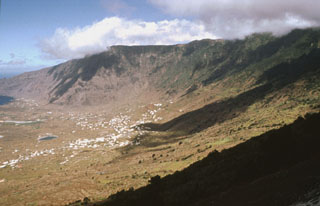
Geological Summary. The triangular island of Hierro is the SW-most and least studied of the Canary Islands. The massive shield volcano is truncated by a large NW-facing escarpment formed as a result of gravitational collapse of El Golfo volcano about 130,000 years ago. The steep-sided scarp towers above a low lava platform bordering 12-km-wide El Golfo Bay, and three other large submarine landslide deposits occur to the SW and SE. Three prominent rifts oriented NW, NE, and S form prominent topographic ridges. The subaerial portion of the volcano consists of flat-lying Quaternary basaltic and trachybasaltic lava flows and tuffs capped by numerous young cinder cones and lava flows. Holocene cones and flows are found both on the outer flanks and in the El Golfo depression. Hierro contains the greatest concentration of young vents in the Canary Islands. Uncertainty surrounds the report of an eruption in 1793. A submarine eruption took place about 2 km SSW off the southern point of the island during 2011-12.
Sources: Instituto Geográfico Nacional (IGN), Associated Press, Gobierno de Canaries