Report on Raikoke (Russia) — 26 June-2 July 2019
Smithsonian Institution / US Geological Survey
Weekly Volcanic Activity Report, 26 June-2 July 2019
Managing Editor: Sally Sennert.
Please cite this report as:
Global Volcanism Program, 2019. Report on Raikoke (Russia) (Sennert, S, ed.). Weekly Volcanic Activity Report, 26 June-2 July 2019. Smithsonian Institution and US Geological Survey.
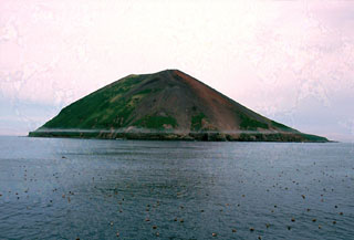
Raikoke
Russia
48.292°N, 153.25°E; summit elev. 551 m
All times are local (unless otherwise noted)
SVERT and KVERT reported that during 25 June-1 July steam-and-gas plumes with ash rose 1.5-2 km above Raikoke and drifted WNW based on satellite images. The Aviation Color Code was lowered to Yellow on 25 June and then to Green on 27 June.
Geological Summary. A low truncated volcano forms the small barren Raikoke Island, which lies 16 km across the Golovnin Strait from Matua Island in the central Kuriles. The oval-shaped basaltic island is only 2 x 2.5 km wide and rises above a submarine terrace. An eruption in 1778, during which the upper third of the island was said to have been destroyed, prompted the first volcanological investigation in the Kuril Islands two years later. Incorrect reports of eruptions in 1777 and 1780 were due to misprints and errors in descriptions of the 1778 event (Gorshkov, 1970). Another powerful eruption in 1924 greatly deepened the crater and changed the outline of the island. Prior to a 2019 eruption, the steep-walled crater, highest on the SE side, was 700 m wide and 200 m deep. Lava flows mantle the eastern side of the island.
Sources: Sakhalin Volcanic Eruption Response Team (SVERT), Kamchatkan Volcanic Eruption Response Team (KVERT)