Report on Fourpeaked (United States) — 20 September-26 September 2006
Smithsonian Institution / US Geological Survey
Weekly Volcanic Activity Report, 20 September-26 September 2006
Managing Editor: Sally Sennert.
Please cite this report as:
Global Volcanism Program, 2006. Report on Fourpeaked (United States) (Sennert, S, ed.). Weekly Volcanic Activity Report, 20 September-26 September 2006. Smithsonian Institution and US Geological Survey.
Fourpeaked
United States
58.77°N, 153.672°W; summit elev. 2105 m
All times are local (unless otherwise noted)
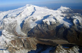
On the evening of 17 September the Alaska Volcano Observatory (AVO) received several reports of two discrete plumes rising from the Cape Douglas area, about 320 km SW of Anchorage. Retrospective analysis of data from the NEXRAD Doppler radar in King Salmon showed an unusual cloud starting at 1200 that day. The maximum cloud height determined by radar during the first hour of the event was 6 km (20,000 ft) a.s.l. The radar return from the cloud continued until at least 2145. A cloud of sulfur dioxide gas was observed by colleagues at the University of Maryland Baltimore County over the Cape Douglas/Fourpeaked region at 1500 using data collected by the Ozone Monitoring Instrument (OMI) on NASA's Aura satellite. On this basis all of the clouds were inferred to be volcanic in origin. Although satellite data did not detect ash during this event, AVO received reports of a trace of ashfall at Nonvianuk Lake outlet (110 km WNW) and near Homer (150 km NE).
Both fixed-wing and helicopter overflights in the Cape Douglas area 20 September confirmed the source of volcanic activity to be Fourpeaked volcano. AVO raised the Level of Concern Color Code from "Not Assigned" to YELLOW on 20 September. Fourpeaked and Douglas volcanoes are not monitored seismically. A 23 September observation flight conducted in relatively good weather permitted the first look at the summit since the event of 17 September. Observers saw a linear series of vents running N from the summit for about 1 km. Most of these vents were vigorously emitting steam and other volcanic gases. Gas measurements indicated abundant quantities of sulfur dioxide, hydrogren sulfide, and carbon dioxide.
Geological Summary. Poorly known Fourpeaked volcano in NE Katmai National Park consists of isolated outcrops surrounded by the Fourpeaked Glacier, which descends eastward almost to the Shelikof Strait. The orientation of andesitic lava flows and extensive hydrothermal alteration of rocks near the present summit suggest that it probably marks the vent area. Eruptive activity during the Holocene had not been confirmed prior to the first historical eruption in September 2006. A N-trending fissure extending 1 km from the summit produced minor ashfall.
Source: US Geological Survey Alaska Volcano Observatory (AVO)