Report on Callaqui (Chile) — 13 February-19 February 2008
Smithsonian Institution / US Geological Survey
Weekly Volcanic Activity Report, 13 February-19 February 2008
Managing Editor: Sally Sennert.
Please cite this report as:
Global Volcanism Program, 2008. Report on Callaqui (Chile) (Sennert, S, ed.). Weekly Volcanic Activity Report, 13 February-19 February 2008. Smithsonian Institution and US Geological Survey.
Callaqui
Chile
37.92°S, 71.45°W; summit elev. 3164 m
All times are local (unless otherwise noted)
According to news articles on 14 February, scientists from the Universidad de Concepción will install instruments to monitor Callaqui. Local residents reported feeling earthquakes and hearing constant rumbling noises during the previous few weeks.
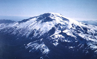
Geological Summary. The late-Pleistocene to Holocene Callaqui stratovolcano has a profile of an overturned canoe, due to its construction along an 11-km-long, SW-NE fissure above a 1.2-0.3 million year old Pleistocene edifice. The ice-capped, basaltic andesite volcano contains well-preserved cones and lava flows, which have traveled up to 14 km. Small craters 100-500 m in diameter are primarily found along a fissure extending down the SW flank. Intense solfataric activity occurs at the southern portion of the summit; in 1966 and 1978, red glow was observed in fumarolic areas (Moreno 1985, pers. comm.). Periods of intense fumarolic activity have dominated; few historical eruptions are known. An explosive eruption was reported in 1751, there were uncertain accounts of eruptions in 1864 and 1937, and a small phreatic ash emission was noted in 1980.
Source: El Mostrador