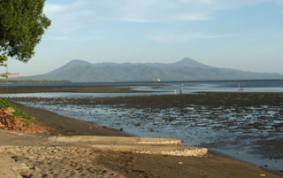
Report on Krummel-Garbuna-Welcker (Papua New Guinea) — 19 March-25 March 2008
Smithsonian Institution / US Geological Survey
Weekly Volcanic Activity Report, 19 March-25 March 2008
Managing Editor: Sally Sennert.
Please cite this report as:
Global Volcanism Program, 2008. Report on Krummel-Garbuna-Welcker (Papua New Guinea) (Sennert, S, ed.). Weekly Volcanic Activity Report, 19 March-25 March 2008. Smithsonian Institution and US Geological Survey.
Krummel-Garbuna-Welcker
Papua New Guinea
5.416°S, 150.027°E; summit elev. 564 m
All times are local (unless otherwise noted)
RVO reported that white plumes from two sources at the summit of Garbuna drifted SE during 19-21 March. Ashfall and a strong sulfur odor were reported in Kimbe Town (about 17 km SE) on 19 March.
Geological Summary. The basaltic-to-dacitic Krummel-Garbuna-Welcker Volcanic Complex consists of three volcanic peaks located along a 7-km N-S line above a shield-like foundation at the southern end of the Willaumez Peninsula. The central and lower peaks of the centrally located Garbuna contain a large vegetation-free area that is probably the most extensive thermal field in Papua New Guinea. A prominent lava dome and blocky lava flow in the center of thermal area have resisted destruction by thermal activity, and may be of Holocene age. Krummel volcano at the south end of the group contains a summit crater, breached to the NW. The highest peak of the group is Welcker volcano, which has fed blocky lava flows that extend to the eastern coast of the peninsula. The last major eruption from both it and Garbuna volcanoes took place about 1800 years ago. The first historical eruption took place at Garbuna in October 2005.
Source: Rabaul Volcano Observatory (RVO)

