Report on Chaiten (Chile) — 30 July-5 August 2008
Smithsonian Institution / US Geological Survey
Weekly Volcanic Activity Report, 30 July-5 August 2008
Managing Editor: Sally Sennert.
Please cite this report as:
Global Volcanism Program, 2008. Report on Chaiten (Chile) (Sennert, S, ed.). Weekly Volcanic Activity Report, 30 July-5 August 2008. Smithsonian Institution and US Geological Survey.
Chaiten
Chile
42.8349°S, 72.6514°W; summit elev. 1122 m
All times are local (unless otherwise noted)
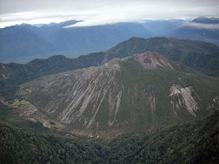
SERNAGEOMIN reported that clouds obscured camera views of Chaitén's eruption plume during most of 30-31July. A glimpse on 31 July revealed that a steam-and-ash plume rose to an altitude of 1.5 km (4,900 ft) a.s.l. Explosions were heard. A steam-and-ash plume was seen at an altitude of about 3.1 km during an overflight on 31 July and drifted NE. The plume was emitted from a fracture caused by a vertical collapse of the S flank of the lava dome. A horseshoe-shaped scar on the E side of the dome, about 500 m wide and 200 m high, formed on an unknown date within the previous several days. The scar was inferred to have formed by a lateral explosion rather than collapse because hummocky morphology typical of landslide deposits was not found below the scar. Material from the explosion was transported by rivers that eventually flowed N into the Rayas River, and also fell in small lagoons at the S base of the dome. On 4 August a small steam plume possibly containing some ash was seen through another quick break in the clouds and drifted E.
Geological Summary. Chaitén is a small caldera (~3 km in diameter) located 10 km NE of the town of Chaitén on the Gulf of Corcovado. Multiple explosive eruptions throughout the Holocene have been identified. A rhyolitic obsidian lava dome occupies much of the caldera floor. Obsidian cobbles from this dome found in the Blanco River are the source of artifacts from archaeological sites along the Pacific coast as far as 400 km from the volcano to the N and S. The caldera is breached on the SW side by a river that drains to the bay of Chaitén. The first recorded eruption, beginning in 2008, produced major rhyolitic explosive activity and building a new dome and tephra cone on the older rhyolite dome.
Source: Servicio Nacional de Geología y Minería (SERNAGEOMIN)

