Report on Chiles-Cerro Negro (Colombia-Ecuador) — 5 November-11 November 2014
Smithsonian Institution / US Geological Survey
Weekly Volcanic Activity Report, 5 November-11 November 2014
Managing Editor: Sally Sennert.
Please cite this report as:
Global Volcanism Program, 2014. Report on Chiles-Cerro Negro (Colombia-Ecuador) (Sennert, S, ed.). Weekly Volcanic Activity Report, 5 November-11 November 2014. Smithsonian Institution and US Geological Survey.
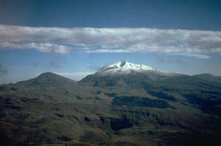
Chiles-Cerro Negro
Colombia-Ecuador
0.817°N, 77.938°W; summit elev. 4698 m
All times are local (unless otherwise noted)
On 4 November Servicio Geológico Colombiano's Observatorio Vulcanológico and Sismológico de Pasto (SGC-OVSP) reported that seismic activity at Cerro Negro de Mayasquer and Chiles volcanoes remained elevated. Since 29 September 2014 about 132,000 earthquakes had been detected, with 3,200 of those events occurring on 4 November. During the previous week hypocenters were located 0.3-6.3 km S and SW of Chiles, at depths of 3-9 km below the summit. Local magnitudes were between 0.7 and 4.6. The Alert Level remained at Orange (level 3 of 4).
Geological Summary. The Chiles-Cerro Negro volcanic complex includes both the Pleistocene Chiles and the Cerro Negro de Mayasquer stratovolcanoes astride the Colombia-Ecuador border. Cerro Negro has a caldera open to the west, with andesitic and dacitic lava flows of possible Holocene age (Hall 1992, pers. comm.) and solfataras on the shore of a small crater lake. An eruption reported in 1936 may have been from Reventador (Catalog of Active Volcanoes of the World). The higher, glacier-covered summit of Chiles, about 4 km ESE of Cerro Negro, last erupted about 160,000 years ago, but it has a caldera open to the north with hot springs and an active hydrothermal system on its eastern flank.