Report on Novarupta (United States) — 8 November-14 November 2017
Smithsonian Institution / US Geological Survey
Weekly Volcanic Activity Report, 8 November-14 November 2017
Managing Editor: Sally Sennert.
Please cite this report as:
Global Volcanism Program, 2017. Report on Novarupta (United States) (Sennert, S, ed.). Weekly Volcanic Activity Report, 8 November-14 November 2017. Smithsonian Institution and US Geological Survey.
Novarupta
United States
58.2655°N, 155.1588°W; summit elev. 841 m
All times are local (unless otherwise noted)
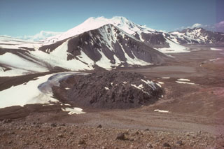
On 13 November AVO reported that a cloud of ash, resuspended by strong winds in the vicinity of Katmai and the Valley of Ten Thousand Smokes, was blown about 120 km SE over Shelikof Strait and Kodiak Island at an altitude of up to 3 km (10,000 ft) a.s.l. The ash was originally deposited during the Novarupta eruption in 1912. The Volcano Alert Level remained at Normal and the Aviation Color Code remained at Green.
Geological Summary. Novarupta, the least topographically prominent volcano in the Katmai area, was formed during a major eruption in 1912. This eruption was the world's largest during the 20th century and produced a voluminous rhyolitic airfall tephra and the renowned Valley of Ten Thousand Smokes (VTTS) ash flow. At the end of the eruption a small, 65-m-high, 400-m-wide lava dome grew within the source vent of the VTTS ashflow, a 2-km-wide area of subsidence NW of Trident volcano. The NE side of the Falling Mountain lava dome of the Trident volcanic cluster, as well as Broken Mountain and Baked Mountain, was removed by collapse of the Novarupta depression, which is marked by radial and scalloped arcuate fractures. Much larger collapse took place at Katmai volcano, 10 km E, where a 3 x 4 km caldera formed in response to magma reservoir drainage toward Novarupta.
Source: US Geological Survey Alaska Volcano Observatory (AVO)