

On 13 November AVO reported that a cloud of ash, resuspended by strong winds in the vicinity of Katmai and the Valley of Ten Thousand Smokes, was blown about 120 km SE over Shelikof Strait and Kodiak Island at an altitude of up to 3 km (10,000 ft) a.s.l. The ash was originally deposited during the Novarupta eruption in 1912. The Volcano Alert Level remained at Normal and the Aviation Color Code remained at Green.
Source: US Geological Survey Alaska Volcano Observatory (AVO)
Strong winds resuspend old ash deposits, causing a large plume and distant ashfall
According to the National Weather Service, strong winds in the Katmai area on 21 September 2003 picked up old, loose volcanic ash and carried it E. Reports of minor ashfall were reported from Kodiak Island, ~ 100 km from Katmai. This phenomenon was not the result of volcanic activity and no eruption occurred.
Andrea Steffke of the Geophysical Institute, University of Alaska Fairbanks, reported a relatively large ash cloud observed in satellite images coming from the Katmai area on 21 September 2003. The cloud was first seen in satellite imagery (AVHRR, GOES, and MODIS) extending ~ 69 km to the SE. The maximum temperature difference observed was -1.46°C. Dave Schneider of the Alaska Volcano Observatory reported on 22 September 2003 that at its greatest extent the cloud was detectable for ~ 400 km. It was initially observed by an overflying (high-altitude) jet, and subsequently identified in split-window images from AVHRR, MODIS, and GOES satellites. Additional pilot reports placed the cloud top at ~ 2.1 km altitude.
The Katmai Group of volcanoes are seismically monitored by AVO, so it was possible to quickly confirm that an eruption had not taken place. SIGMETS were issued by the Alaska Aviation Weather Unit (AAWU) for this event and an AVO Information Release was distributed that indicated that this cloud of re-suspended ash was potentially hazardous to aircraft. This event is unusual in its intensity and extent of transport. The Katmai region is characterized by frequent high winds that can be strong enough to re-suspend large (several centimeters in size) pumice fragments, yet these events typically don't produce large, extensive airborne ash clouds.
Information Contacts: Alaska Volcano Observatory (AVO), a cooperative program of the U.S. Geological Survey, 4200 University Drive, Anchorage, AK 99508-4667, USA (URL: http://www.avo.alaska.edu/), the Geophysical Institute, University of Alaska, PO Box 757320, Fairbanks, AK 99775-7320, USA, and the Alaska Division of Geological and Geophysical Surveys, 794 University Ave., Suite 200, Fairbanks, AK 99709, USA.
2017: November
2016: December
2011: May
2010: November
2005: November
2003: September
On 13 November AVO reported that a cloud of ash, resuspended by strong winds in the vicinity of Katmai and the Valley of Ten Thousand Smokes, was blown about 120 km SE over Shelikof Strait and Kodiak Island at an altitude of up to 3 km (10,000 ft) a.s.l. The ash was originally deposited during the Novarupta eruption in 1912. The Volcano Alert Level remained at Normal and the Aviation Color Code remained at Green.
Source: US Geological Survey Alaska Volcano Observatory (AVO)
According to NASA's Earth Observatory, a Moderate Resolution Imaging Spectroradiometer (MODIS) satellite image acquired on 2 December of the Katmai area showed a plume of re-suspended ash which had been deposited during the 1912 eruption.
Source: NASA Earth Observatory
Based on analysis of satellite imagery, pilot observations, KVERT reports, and information from AVO, the Anchorage VAAC reported that on 11 May strong winds in the Katmai area re-suspended loose ash deposited during the 1912 eruption. The Volcano Alert Level remained at Normal and the Aviation Color Code remained at Green.
Source: Anchorage Volcanic Ash Advisory Center (VAAC)
Based on analysis of satellite imagery and information from AVO, the Anchorage VAAC reported that on 29 November strong winds in the Katmai area picked up loose ash deposited during the 1912 eruption and carried it SE over Kodiak Island. The Volcano Alert Level remained at Normal and the Aviation Color Code remained at Green.
Source: Anchorage Volcanic Ash Advisory Center (VAAC)
Strong winds in the Katmai area picked up loose ash deposited during the 1912 eruption and carried it E over Kodiak Island. AVO recorded a large area of resuspended ash on satellite imagery. The National Weather Service estimated that the top of the plume was at 1.5 km (5,000 ft) a.s.l. Katmai remained at Concern Color Code Green.
Source: US Geological Survey Alaska Volcano Observatory (AVO)
According to the National Weather Service, strong winds on 21 September in the Katmai area picked up old, loose volcanic ash and carried it E over Kodiak Island. AVO received reports that some of this material fell in Kodiak. This was not the result of volcanic activity and no eruption occurred. Re-suspended volcanic ash should be considered as hazardous as primary volcanic ash, and a threat to aircraft. The volcanoes in the Katmai cluster remained at Concern Color Code Green.
Source: US Geological Survey Alaska Volcano Observatory (AVO)
Reports are organized chronologically and indexed below by Month/Year (Publication Volume:Number), and include a one-line summary. Click on the index link or scroll down to read the reports.
Strong winds resuspend old ash deposits, causing a large plume and distant ashfall
According to the National Weather Service, strong winds in the Katmai area on 21 September 2003 picked up old, loose volcanic ash and carried it E. Reports of minor ashfall were reported from Kodiak Island, ~ 100 km from Katmai. This phenomenon was not the result of volcanic activity and no eruption occurred.
Andrea Steffke of the Geophysical Institute, University of Alaska Fairbanks, reported a relatively large ash cloud observed in satellite images coming from the Katmai area on 21 September 2003. The cloud was first seen in satellite imagery (AVHRR, GOES, and MODIS) extending ~ 69 km to the SE. The maximum temperature difference observed was -1.46°C. Dave Schneider of the Alaska Volcano Observatory reported on 22 September 2003 that at its greatest extent the cloud was detectable for ~ 400 km. It was initially observed by an overflying (high-altitude) jet, and subsequently identified in split-window images from AVHRR, MODIS, and GOES satellites. Additional pilot reports placed the cloud top at ~ 2.1 km altitude.
The Katmai Group of volcanoes are seismically monitored by AVO, so it was possible to quickly confirm that an eruption had not taken place. SIGMETS were issued by the Alaska Aviation Weather Unit (AAWU) for this event and an AVO Information Release was distributed that indicated that this cloud of re-suspended ash was potentially hazardous to aircraft. This event is unusual in its intensity and extent of transport. The Katmai region is characterized by frequent high winds that can be strong enough to re-suspend large (several centimeters in size) pumice fragments, yet these events typically don't produce large, extensive airborne ash clouds.
Information Contacts: Alaska Volcano Observatory (AVO), a cooperative program of the U.S. Geological Survey, 4200 University Drive, Anchorage, AK 99508-4667, USA (URL: http://www.avo.alaska.edu/), the Geophysical Institute, University of Alaska, PO Box 757320, Fairbanks, AK 99775-7320, USA, and the Alaska Division of Geological and Geophysical Surveys, 794 University Ave., Suite 200, Fairbanks, AK 99709, USA.
|
|
||||||||||||||||||||||||||||
There is data available for 1 confirmed Holocene eruptive periods.
[ 1950 Jul 5 ± 4 days ] Discredited Eruption
[ 1949 May 19 ] Discredited Eruption
1912 Jun 6 - 1912 Oct (?) Confirmed Eruption (Explosive / Effusive) VEI: 6
| Episode 1 | Eruption (Explosive / Effusive) | ||||||||||||||||||||||||||||||||||||||||||||||||||||||||||||||||||||||
|---|---|---|---|---|---|---|---|---|---|---|---|---|---|---|---|---|---|---|---|---|---|---|---|---|---|---|---|---|---|---|---|---|---|---|---|---|---|---|---|---|---|---|---|---|---|---|---|---|---|---|---|---|---|---|---|---|---|---|---|---|---|---|---|---|---|---|---|---|---|---|
| 1912 Jun 6 - 1912 Oct (?) | Evidence from Observations: Reported | |||||||||||||||||||||||||||||||||||||||||||||||||||||||||||||||||||||
|
List of 12 Events for Episode 1
|
||||||||||||||||||||||||||||||||||||||||||||||||||||||||||||||||||||||
The Global Volcanism Program has no synonyms or subfeatures listed for Novarupta.
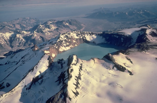 Alaska's lake-filled Katmai caldera, seen here from the SE, collapsed during a catastrophic eruption in 1912 of Novarupta volcano, hidden behind the far caldera wall 10 km to the west. Little tephra was erupted from Katmai itself, but Novarupta produced the Valley of Ten Thousand Smokes ash flow, whose deposits form the broad flat valley in the right distance. Prior to 1912, Mount Katmai was a 2290-m-high complex of 4 small stratovolcanoes, similar to Trident volcano to the SW.
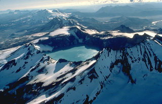 This 1978 aerial view from the NE looks down the SW-trending chain of closely spaced volcanoes in Katmai National Park. Katmai volcano, in the foreground, is truncated by a 4.5-km-wide caldera created by collapse of the volcano in 1912 at the time of the major eruption at Novarupta volcano, 10 km to the west and below the far rim of Katmai caldera. Beyond Katmai, in line with the 250-m-deep caldera lake, are the dark-colored peaks of the Trident complex and the broad, glacier-covered slopes of Mageik volcano.
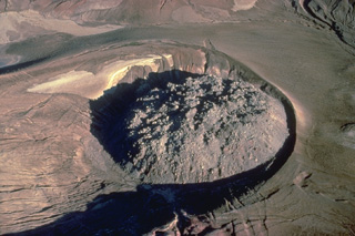 A 380-m wide lava dome caps the 1912 vent of Alaska's Novarupta volcano. The 65-m-high rhyolitic lava dome, which lies within a circular ejecta ring, was erupted at the end of a powerful explosive eruption that produced the voluminous Valley of Ten Thousand Smokes ash flows.
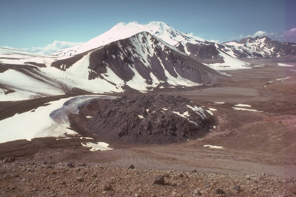
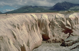 Alaska's Valley of Ten Thousand Smokes is filled with deposits from one of Earth's largest ash flows during historical time. They were emplaced during a powerful eruption on June 6, 1912, from Novarupta volcano, a newly formed volcano 10 km west of Katmai volcano. Stream dissection of the easily eroded, unwelded ash-flow deposit since 1912 provides a cross-sectional view of its interior. The person standing on its surface at the left provides scale for the deposit, which covers an area of 120 cu km and has a volume 11-15 cu km.
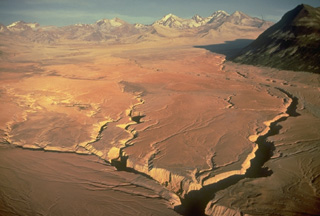 This entire valley floor consists of deposits of the Valley of Ten Thousand Smokes (VTTS) ash flow, which was erupted from Alaska's Novarupta volcano, out of view to the left. The massive, 11-15 cu km VTTS ash-flow covers 120 km2 of the valley to a distance of 12 km from the Novarupta vent. The bowl-shaped portion of the left-half skyline is the rim of Katmai caldera, which collapsed as a result of the eruption of the VTTS ash flow. The four skyline peaks on the right side of this aerial view from the NW are those of Trident volcano.
 A lava dome 65 m high and 380 m wide lies within a circular ejecta ring and caps the 1912 vent of Novarupta volcano. A 60-hour-long eruption that began on 6 June 1912 was the largest eruption during the 20th century, producing The Valley of Ten Thousand Smokes pyroclastic flow deposit which forms the flat ground to the right. The face of Falling Mountain, behind Novarupta dome, was sheared off by a 2-km-wide collapse around the vent. This view from the NE shows snow-capped Mageik in the background.
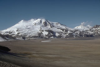 Mount Mageik (left) and Mount Martin (distant right) tower above the flat floor of the Valley of Ten Thousand Smokes. The deposits in the valley are pyroclastic flows that formed during the 1912 eruption of Novarupta, the largest eruption of the 20th century. Glacier-covered Mageik has a broad summit containing multiple cones and vents.
The following 14 samples associated with this volcano can be found in the Smithsonian's NMNH Department of Mineral Sciences collections, and may be availble for research (contact the Rock and Ore Collections Manager). Catalog number links will open a window with more information.
| Catalog Number | Sample Description | Lava Source | Collection Date |
|---|---|---|---|
| NMNH 108924 | Rhyolite | -- | -- |
| NMNH 116660-1 | Andesite-Dacite Pumice | -- | -- |
| NMNH 116660-2 | Andesite-Dacite Pumice | -- | -- |
| NMNH 116660-3 | Andesite Pumice | -- | -- |
| NMNH 116660-5 | Rhyolite Pumice | -- | -- |
| NMNH 117233-84 | Tuff | -- | -- |
| NMNH 117233-85 | Tuff | -- | -- |
| NMNH 117233-86 | Tuff | -- | -- |
| NMNH 117233-87 | Tuff | -- | -- |
| NMNH 117259-20 | Fumarole Deposit | -- | -- |
| NMNH 117259-21 | Fumarole Deposit | -- | -- |
| NMNH 117259-22 | Fumarole Deposit | -- | -- |
| NMNH 117259-23 | Fumarole Deposit | -- | 2 Aug 1919 |
| NMNH 117259-24 | Fumarole Deposit | -- | 2 Aug 1919 |
| Alaska Volcano Observatory (Link to Novarupta) | The Alaska Volcano Observatory (AVO) is a joint program of the U.S. Geological Survey (USGS), the Geophysical Institute of the University of Alaska Fairbanks (UAFGI), and the State of Alaska Division of Geological and Geophysical Surveys (ADGGS). AVO was formed in 1988, and uses federal, state, and university resources to monitor and study Alaska's hazardous volcanoes, to predict and record eruptive activity, and to mitigate volcanic hazards to life and property. |
| Copernicus Browser | The Copernicus Browser replaced the Sentinel Hub Playground browser in 2023, to provide access to Earth observation archives from the Copernicus Data Space Ecosystem, the main distribution platform for data from the EU Copernicus missions. |
| MIROVA | Middle InfraRed Observation of Volcanic Activity (MIROVA) is a near real time volcanic hot-spot detection system based on the analysis of MODIS (Moderate Resolution Imaging Spectroradiometer) data. In particular, MIROVA uses the Middle InfraRed Radiation (MIR), measured over target volcanoes, in order to detect, locate and measure the heat radiation sourced from volcanic activity. |
| MODVOLC Thermal Alerts | Using infrared satellite Moderate Resolution Imaging Spectroradiometer (MODIS) data, scientists at the Hawai'i Institute of Geophysics and Planetology, University of Hawai'i, developed an automated system called MODVOLC to map thermal hot-spots in near real time. For each MODIS image, the algorithm automatically scans each 1 km pixel within it to check for high-temperature hot-spots. When one is found the date, time, location, and intensity are recorded. MODIS looks at every square km of the Earth every 48 hours, once during the day and once during the night, and the presence of two MODIS sensors in space allows at least four hot-spot observations every two days. Each day updated global maps are compiled to display the locations of all hot spots detected in the previous 24 hours. There is a drop-down list with volcano names which allow users to 'zoom-in' and examine the distribution of hot-spots at a variety of spatial scales. |
|
WOVOdat
Single Volcano View Temporal Evolution of Unrest Side by Side Volcanoes |
WOVOdat is a database of volcanic unrest; instrumentally and visually recorded changes in seismicity, ground deformation, gas emission, and other parameters from their normal baselines. It is sponsored by the World Organization of Volcano Observatories (WOVO) and presently hosted at the Earth Observatory of Singapore.
GVMID Data on Volcano Monitoring Infrastructure The Global Volcano Monitoring Infrastructure Database GVMID, is aimed at documenting and improving capabilities of volcano monitoring from the ground and space. GVMID should provide a snapshot and baseline view of the techniques and instrumentation that are in place at various volcanoes, which can be use by volcano observatories as reference to setup new monitoring system or improving networks at a specific volcano. These data will allow identification of what monitoring gaps exist, which can be then targeted by remote sensing infrastructure and future instrument deployments. |
| Volcanic Hazard Maps | The IAVCEI Commission on Volcanic Hazards and Risk has a Volcanic Hazard Maps database designed to serve as a resource for hazard mappers (or other interested parties) to explore how common issues in hazard map development have been addressed at different volcanoes, in different countries, for different hazards, and for different intended audiences. In addition to the comprehensive, searchable Volcanic Hazard Maps Database, this website contains information about diversity of volcanic hazard maps, illustrated using examples from the database. This site is for educational purposes related to volcanic hazard maps. Hazard maps found on this website should not be used for emergency purposes. For the most recent, official hazard map for a particular volcano, please seek out the proper institutional authorities on the matter. |
| IRIS seismic stations/networks | Incorporated Research Institutions for Seismology (IRIS) Data Services map showing the location of seismic stations from all available networks (permanent or temporary) within a radius of 0.18° (about 20 km at mid-latitudes) from the given location of Novarupta. Users can customize a variety of filters and options in the left panel. Note that if there are no stations are known the map will default to show the entire world with a "No data matched request" error notice. |
| UNAVCO GPS/GNSS stations | Geodetic Data Services map from UNAVCO showing the location of GPS/GNSS stations from all available networks (permanent or temporary) within a radius of 20 km from the given location of Novarupta. Users can customize the data search based on station or network names, location, and time window. Requires Adobe Flash Player. |
| DECADE Data | The DECADE portal, still in the developmental stage, serves as an example of the proposed interoperability between The Smithsonian Institution's Global Volcanism Program, the Mapping Gas Emissions (MaGa) Database, and the EarthChem Geochemical Portal. The Deep Earth Carbon Degassing (DECADE) initiative seeks to use new and established technologies to determine accurate global fluxes of volcanic CO2 to the atmosphere, but installing CO2 monitoring networks on 20 of the world's 150 most actively degassing volcanoes. The group uses related laboratory-based studies (direct gas sampling and analysis, melt inclusions) to provide new data for direct degassing of deep earth carbon to the atmosphere. |
| Large Eruptions of Novarupta | Information about large Quaternary eruptions (VEI >= 4) is cataloged in the Large Magnitude Explosive Volcanic Eruptions (LaMEVE) database of the Volcano Global Risk Identification and Analysis Project (VOGRIPA). |
| EarthChem | EarthChem develops and maintains databases, software, and services that support the preservation, discovery, access and analysis of geochemical data, and facilitate their integration with the broad array of other available earth science parameters. EarthChem is operated by a joint team of disciplinary scientists, data scientists, data managers and information technology developers who are part of the NSF-funded data facility Integrated Earth Data Applications (IEDA). IEDA is a collaborative effort of EarthChem and the Marine Geoscience Data System (MGDS). |