Report on Myojinsho (Japan) — 21 March-27 March 2018
Smithsonian Institution / US Geological Survey
Weekly Volcanic Activity Report, 21 March-27 March 2018
Managing Editor: Sally Sennert.
Please cite this report as:
Global Volcanism Program, 2018. Report on Myojinsho (Japan) (Sennert, S, ed.). Weekly Volcanic Activity Report, 21 March-27 March 2018. Smithsonian Institution and US Geological Survey.
Myojinsho
Japan
31.888°N, 139.918°E; summit elev. 11 m
All times are local (unless otherwise noted)
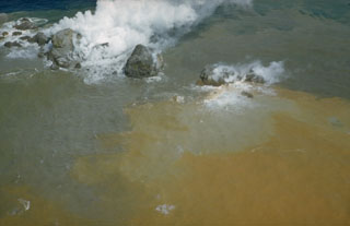
JMA issued a warning on 24 March for the waters surrounding Myojinsho after reports from the Japan Coast Guard indicated discolored water from a possible eruptive event.
Geological Summary. Beyonesu Rocks are part of the barely exposed rim of the largely submarine Myojinsho caldera. Formation of the 8-9 km wide caldera was followed by construction of a large (2.6 km3) lava dome and/or lava flow complex on the caldera floor, originally located at a depth of 1,000-1,100 m. Most eruptions recorded since the late-19th century have occurred from the dacitic post-caldera Myojinsho lava dome on the NE caldera rim. Deposits from submarine pyroclastic flows associated with growth of the dome cover it and extend both into the NE part of the caldera and down its outer slopes. An explosive submarine eruption from Myojinsho in 1952 destroyed a Japanese research vessel, killing all 31 on board. Submarine eruptions have also been observed from other points on the caldera rim and outside of the caldera. The Beyonesu Rocks were named after the French warship the Bayonnaise, which was surveying volcanic islands south of Tokyo Bay in 1850.