Report on Sierra Negra (Ecuador) — 11 July-17 July 2018
Smithsonian Institution / US Geological Survey
Weekly Volcanic Activity Report, 11 July-17 July 2018
Managing Editor: Sally Sennert.
Please cite this report as:
Global Volcanism Program, 2018. Report on Sierra Negra (Ecuador) (Sennert, S, ed.). Weekly Volcanic Activity Report, 11 July-17 July 2018. Smithsonian Institution and US Geological Survey.
Sierra Negra
Ecuador
0.83°S, 91.17°W; summit elev. 1124 m
All times are local (unless otherwise noted)
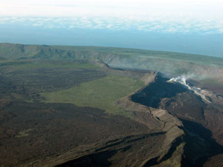
Based on satellite data and wind model data, the Washington VAAC reported that on 11 July gas-and-ash plumes from Sierra Negra rose 3.7 km (12,000 ft) a.s.l. and drifted almost 85 km W. Gas plumes on 13 July drifted N, NW, and SW. On 16 July gas plumes with minor amounts of ash rose 2.4 km (8,000 ft) a.s.l. and drifted SW. Incandescence was visible in webcam images.
Geological Summary. The broad shield volcano of Sierra Negra at the southern end of Isabela Island contains a shallow 7 x 10.5 km caldera that is the largest in the Galápagos Islands. Flank vents abound, including cinder cones and spatter cones concentrated along an ENE-trending rift system and tuff cones along the coast and forming offshore islands. Although it is the largest of the five major Isabela volcanoes, it has the flattest slopes, averaging less than 5° and diminishing to 2° near the coast. A sinuous 14-km-long, N-S-trending ridge occupies the west part of the caldera floor, which lies only about 100 m below its rim. The Volcán de Azufre fumarolic area lies within a graben between this ridge and the west caldera wall. Lava flows from a major eruption in 1979 extend all the way to the north coast from circumferential fissure vents on the upper northern flank.