Report on La Palma (Spain) — 27 October-2 November 2021
Smithsonian Institution / US Geological Survey
Weekly Volcanic Activity Report, 27 October-2 November 2021
Managing Editor: Sally Sennert.
Please cite this report as:
Global Volcanism Program, 2021. Report on La Palma (Spain) (Sennert, S, ed.). Weekly Volcanic Activity Report, 27 October-2 November 2021. Smithsonian Institution and US Geological Survey.
La Palma
Spain
28.57°N, 17.83°W; summit elev. 2426 m
All times are local (unless otherwise noted)
The eruption at La Palma continued during 26 October-2 November, characterized by Strombolian explosions, lava fountaining from multiple vents, advancing and branching lava flows, and daily ash emissions. Eruption details are based on official sources including PEVOLCA (Plan de Emergencias Volcánicas de Canarias) steering committee summaries issued daily. Seismicity remained elevated, with most earthquakes located 10-15 km deep (though some were as deep as 38 km); dozens of events were felt by local residents and some were felt across the entire island. A M 5 earthquake was recorded at 0724 on 30 October at a depth of 35 km and was the largest earthquake recorded since the beginning of the eruption. A second M 5 earthquake was recorded at 1852 on 1 November and had a depth of 38 km. Both of these events, as well as some of the other notable earthquakes, were felt across La Palma Island and in some areas of La Gomera and Tenerife islands.
The vents in the main cone continued to effuse lava, eject tephra, and produce sometimes dense and billowing ash-and-gas plumes that rose 2.2-5 km (7,200-16,400 ft) a.s.l. Several vents in the main cone were active, though the activity levels varied in intensity throughout the week. A small collapse of the upper part of the main cone on 26 October caused lava to flow W over previous flows that filled in some small gaps where they had not previously covered. Beginning around noon on 29 October a series of intense and audible explosions occurred for several hours, generating a large amount of ash that was distributed across the valley. The tallest ash plumes were observed during 30-31 October. Audible explosions and significant ash emissions continued intermittently through 2 November, with ashfall affecting the entire W and NW parts of the island. Authorities issued multiple air quality alerts warning residents of some affected areas (Los Llanos de Aridane in particular), to stay indoors and, if going outside, to wear a filtering mask. For a period of time on 31 October the larger explosions were accompanied by shock waves and concurrently, the effusion rate at the NW flank vent notably increased. Sulfur dioxide emissions fluctuated at high levels between 4,990 and 22,000 tons per day during 27 October-2 November and showed an overall downward trend during the last week in October; no estimates were made on 29 October due to technical difficulties.
Lava effused at a high rate from a vent on the NW flank of the main cone, flowing through pre-existing lava channels and tubes, and occasionally breaking out and forming new flows. The lava-flow field was characterized by three main areas: the initial main flow that traveled W, flowing around the S part of Montaña de Todoque, toward the sea and creating a lava delta, a flow that had branched off of the main flow to the S, and the flows that traveled W along the N margins of the main flow. Lava flows sometimes overflowed their channels, forming ephemeral flows that spread laterally, descended short distances, and were also transported downslope in lava tubes. The initial flow that reached the sea and formed the delta was not notably fed and was 30 m thick in some areas. The lava flows that had advanced W along the S side of Montaña de La Laguna was 86 m from the coast of Tazacorte, near the beach of El Perdido. The southern flow had advanced at a low rate and by 28 October was 400 m from the sea by 27 October. Lava that travelled SW over older flows emplaced along the S margins of the flow field overflowed the channel, bifurcated, and quickly advanced 1.5 km W and SW over new ground during 28-30 October. This lava flow continued to advance and by 2 November it was 150 m from the LP-211 road, though the advancement rate had slowed considerably to 1 meter per hour. Overall, the flow field widened to 3.1 km, with most of the expansion occurring along the S margins, and covered an estimated 9.77 square kilometers by 2 November.
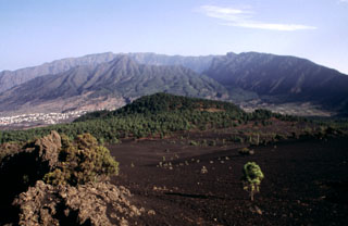
Geological Summary. The 47-km-long wedge-shaped island of La Palma, the NW-most of the Canary Islands, is composed of two large volcanic centers. The older northern one is cut by the steep-walled Caldera Taburiente, one of several massive collapse scarps produced by edifice failure to the SW. On the south, the younger Cumbre Vieja volcano is one of the most active in the Canaries. The elongated volcano dates back to about 125,000 years ago and is oriented N-S. Eruptions during the past 7,000 years have formed abundant cinder cones and craters along the axis, producing fissure-fed lava flows that descend steeply to the sea. Eruptions recorded since the 15th century have produced mild explosive activity and lava flows that damaged populated areas. The southern tip of the island is mantled by a broad lava field emplaced during the 1677-1678 eruption. Lava flows also reached the sea in 1585, 1646, 1712, 1949, 1971, and 2021.
Sources: Instituto Volcanológico de Canarias (INVOLCAN), Instituto Geográfico Nacional (IGN), Gobierno de Canaries