Report on Ruang (Indonesia) — 13 April-19 April 2022
Smithsonian Institution / US Geological Survey
Weekly Volcanic Activity Report, 13 April-19 April 2022
Managing Editor: Sally Sennert.
Please cite this report as:
Global Volcanism Program, 2022. Report on Ruang (Indonesia) (Sennert, S, ed.). Weekly Volcanic Activity Report, 13 April-19 April 2022. Smithsonian Institution and US Geological Survey.
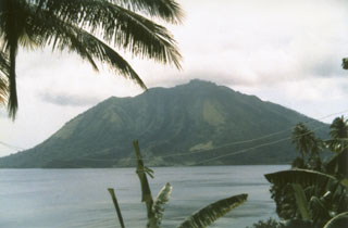
Ruang
Indonesia
2.3058°N, 125.3671°E; summit elev. 703 m
All times are local (unless otherwise noted)
PVMBG reported that at least 121 deep volcanic earthquakes at Ruang were recorded during 1-16 April, though the number of those events began to increase on 7 April. No visible changes to the crater were noted, but weather conditions sometimes prevented views. Seismicity significantly changed on 16 April, characterized by 50 deep volcanic earthquakes, two local tectonic earthquakes, and four felt earthquakes. That same day the Alert Level was raised to 2 (on a scale of 1-4) and residents and tourists were warned to stay 1.5 km away from the active craters and 2.5 km on the E, SE, S, and SW flanks. Elevated seismicity continued to be recorded through 18 April.
Geological Summary. Ruang volcano is the southernmost volcano in the Sangihe Island arc, north of Sulawesi Island; it is not the better known Raung volcano on Java. The 4 x 5 km island volcano is across a narrow strait SW of the larger Tagulandang Island. The summit contains a crater partially filled by a lava dome initially emplaced in 1904. Explosive eruptions recorded since 1808 have often been accompanied by lava dome formation and pyroclastic flows that have damaged inhabited areas.
Source: Pusat Vulkanologi dan Mitigasi Bencana Geologi (PVMBG, also known as CVGHM)