Report on Krysuvik-Trolladyngja (Iceland) — 14 September-20 September 2022
Smithsonian Institution / US Geological Survey
Weekly Volcanic Activity Report, 14 September-20 September 2022
Managing Editor: Sally Sennert.
Please cite this report as:
Global Volcanism Program, 2022. Report on Krysuvik-Trolladyngja (Iceland) (Sennert, S, ed.). Weekly Volcanic Activity Report, 14 September-20 September 2022. Smithsonian Institution and US Geological Survey.
Krysuvik-Trolladyngja
Iceland
63.917°N, 22.067°W; summit elev. 360 m
All times are local (unless otherwise noted)
IMO stated that the Fagradalsfjall and Krýsuvík-Trölladyngja volcanic systems have been designated as two separate systems based on previous scientific research combined with data collected and analyzed from the two recent eruptions (2021 and 2022). On 15 September the Aviation Color Code for Krýsuvík-Trölladyngja was changed to Green, reflecting that the activity was at known background levels.
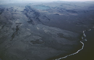
Geological Summary. The Krýsuvík-Trölladyngja volcanic system is described by the Catalogue of Icelandic Volcanoes as an approximately 50-km-long composite fissure swarm trending about N38°E, including a 30-km-long swarm of fissures, with no central volcano. It is one of the volcanic systems arranged en-echelon along the Reykjanes Peninsula west of Kleifarvatn lake. The Fagradalsfjall and Krýsuvík fissure swarms are considered splits or secondary swarms of the Krýsuvík–Trölladyngja volcanic system. Small shield volcanoes have produced a large portion of the erupted volume within the system. Several eruptions have taken place since the settlement of Iceland, including the eruption of a large basaltic lava flow from the Ogmundargigar crater row around the 12th century. The latest eruption, identified through tephrochronology, took place during the 14th century.