Report on Maly Semyachik (Russia) — 26 October-1 November 2022
Smithsonian Institution / US Geological Survey
Weekly Volcanic Activity Report, 26 October-1 November 2022
Managing Editor: Sally Sennert.
Please cite this report as:
Global Volcanism Program, 2022. Report on Maly Semyachik (Russia) (Sennert, S, ed.). Weekly Volcanic Activity Report, 26 October-1 November 2022. Smithsonian Institution and US Geological Survey.
Maly Semyachik
Russia
54.135°N, 159.674°E; summit elev. 1527 m
All times are local (unless otherwise noted)
Although Maly Semyachik was not erupting, KVERT raised the Aviation Color Code to Orange (the second highest level on a four-color scale) on 28 October, noting that a plume of ash, re-suspended by strong winds, was visible in satellite images drifting 123 km SE. Within three hours the Aviation Color Code was lowered back to Green. Dates are based on UTC times; specific events are in local time where noted.
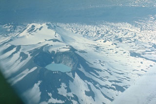
Geological Summary. Maly Semyachik is a compound stratovolcano located in a 10-km-wide caldera within the 15 x 20 km mid-Pleistocene Stena-Soboliny caldera. Following construction during the late Pleistocene of the Paleo-Semiachik volcano beginning about 20,000 years before present (BP), activity migrated to the SW, forming Meso-Semiachik (about 11,000-9,000 BP) and Ceno-Semiachik (about 8,000 BP to the present). An initial stage lasting about 3,500 years was dominantly explosive, constructing the present cone. A second stage beginning about 4,400 years ago was marked by alternating constructive and destructive processes. A crater lake fills the historically active Troitsky Crater, which formed during a large explosive eruption about 400 years ago.