Report on San Miguel (El Salvador) — 23 November-29 November 2022
Smithsonian Institution / US Geological Survey
Weekly Volcanic Activity Report, 23 November-29 November 2022
Managing Editor: Sally Sennert.
Please cite this report as:
Global Volcanism Program, 2022. Report on San Miguel (El Salvador) (Sennert, S, ed.). Weekly Volcanic Activity Report, 23 November-29 November 2022. Smithsonian Institution and US Geological Survey.
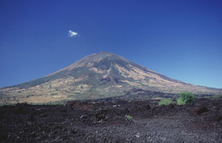
San Miguel
El Salvador
13.434°N, 88.269°W; summit elev. 2130 m
All times are local (unless otherwise noted)
MARN reported that the eruption at San Miguel continued during 23-28 November. Daily phreatic explosions produced gas, steam, and ash emissions that generally rose around 500 m above the crater rim. There were a total of 188 events recorded by 28 November, with a daily average of 13. The explosions were more energetic mid-week; explosions at 1302 and 1642 on 26 November and 0718 and 0802 on 27 November ejected hot rocks onto the flanks and produced eruption plumes that rose as high as 1.1 km above the summit. A cow was killed by hot ballistics during the morning of 27 November, according to a news article. El Director General de Protección Civil issued a Green Alert for the municipalities of Chinameca, San Rafael Oriente, and San Jorge, and warned the public to stay 3 km away from the volcano. The notice recommended that those living within a 3-6 km radius should identify evacuation routes and to take preparation measures as guided by the Sistema Nacional de Protección Civil.
Sulfur dioxide emissions generally averaged 283 tons per day during 26-27 November, below the baseline of 300 tons per day. Specific measurements during explosive events revealed that the emissions were sometimes as high as 1,200 tons per day. MARN warned the public to stay 2 km away from the volcano, and for those living within a 2-5 km radius to identify evacuation routes and to take preparation measures as guided by the Sistema Nacional de Protección Civil.
Geological Summary. The symmetrical cone of San Miguel, one of the most active volcanoes in El Salvador, rises from near sea level to form one of the country's most prominent landmarks. A broad, deep, crater complex that has been frequently modified by eruptions recorded since the early 16th century caps the truncated unvegetated summit, also known locally as Chaparrastique. Flanks eruptions of the basaltic-andesitic volcano have produced many lava flows, including several during the 17th-19th centuries that extended to the N, NE, and SE. The SE-flank flows are the largest and form broad, sparsely vegetated lava fields crossed by highways and a railroad skirting the base of the volcano. Flank vent locations have migrated higher on the edifice during historical time, and the most recent activity has consisted of minor ash eruptions from the summit crater.
Sources: Ministerio de Medio Ambiente y Recursos Naturales (MARN), ASAP Televisión, Protección Civil de El Salvador