Report on Inielika (Indonesia) — 4 October-10 October 2023
Smithsonian Institution / US Geological Survey
Weekly Volcanic Activity Report, 4 October-10 October 2023
Managing Editor: Sally Sennert.
Please cite this report as:
Global Volcanism Program, 2023. Report on Inielika (Indonesia) (Sennert, S, ed.). Weekly Volcanic Activity Report, 4 October-10 October 2023. Smithsonian Institution and US Geological Survey.
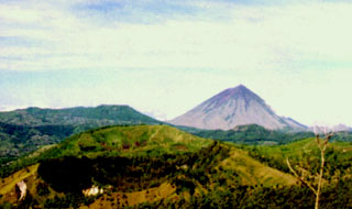
Inielika
Indonesia
8.73°S, 120.98°E; summit elev. 1559 m
All times are local (unless otherwise noted)
PVMBG reported that seismicity at Inielika generally consisted of low levels of low-frequency earthquakes and 0-1 daily deep volcanic earthquakes. Seismicity began to increase on 29 September and remained elevated at least through 4 October. The daily number of deep volcanic earthquakes increased to an average of 9, though notably a total of 17 were recorded on 1 October and 18 were recorded on 3 October. The temperatures and gas concentrations at four hot spring locations had significantly decreased compared to July measurements. The Alert Level was raised to 2 (on a scale of 1-4) at 1000 on 4 October due to increased potential for a phreatic eruption; the public was warned to stay at least 1 km away from the summit crater and to stay away from solfatara zones.
Geological Summary. Inielika is a broad, low volcano in central Flores Island that was constructed within the Lobobutu caldera. The complex summit contains ten craters, some of which are lake filled, in a 5 km2 area north of the city of Bajawa. The largest of these, Wolo Runu and Wolo Lega North, are 750 m wide. A phreatic explosion in 1905 formed a new crater, and was the volcano's only eruption during the 20th century. Another eruption took place about a century later, in 2001. A chain of Pleistocene cinder cones, the Bajawa cinder cone complex, extends southward to Inierie.
Source: Pusat Vulkanologi dan Mitigasi Bencana Geologi (PVMBG, also known as CVGHM)