Report on Shishaldin (United States) — 18 October-24 October 2023
Smithsonian Institution / US Geological Survey
Weekly Volcanic Activity Report, 18 October-24 October 2023
Managing Editor: Sally Sennert.
Please cite this report as:
Global Volcanism Program, 2023. Report on Shishaldin (United States) (Sennert, S, ed.). Weekly Volcanic Activity Report, 18 October-24 October 2023. Smithsonian Institution and US Geological Survey.
Shishaldin
United States
54.756°N, 163.97°W; summit elev. 2857 m
All times are local (unless otherwise noted)
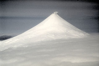
AVO reported that activity at Shishaldin through 24 October had remained elevated since the last explosive event which occurred on 3 October. Sulfur dioxide emissions were elevated with daily averages of more than 1,000 tons per day based on satellite data; during periods in between previous explosive events, sulfur dioxide emissions were either low or were not detected. Abundant amounts of steam rose from the summit as well as from a liner feature that extended about 400 m from the summit down the NE flank. Seismicity remained elevated and was characterized by nearly constant seismic tremor and frequent, small, long-period, or low-frequency earthquakes. The seismicity was indicative of the movement of volcanic fluids and gases within the volcano and had been typically low in between previous explosive events. Daily elevated surface temperatures were identified in satellite data, though temperatures were inconsistent with lava at the surface. Pilots reported a prominent steam plume drifting 40 km WSW at altitudes of 3-4.6 km (10,000-15,000 ft) a.s.l. during the afternoon of 21 October. Minor steam emissions were visible in webcam images during 22-24 October. The Volcano Alert Level remained at Watch (the third level on a four-level scale) and the Aviation Color Code remained at Orange (the third color on a four-color scale).
Geological Summary. The symmetrical glacier-covered Shishaldin in the Aleutian Islands is the westernmost of three large stratovolcanoes in the eastern half of Unimak Island. The Aleuts named the volcano Sisquk, meaning "mountain which points the way when I am lost." Constructed atop an older glacially dissected edifice, it is largely basaltic in composition. Remnants of an older edifice are exposed on the W and NE sides at 1,500-1,800 m elevation. There are over two dozen pyroclastic cones on its NW flank, which is covered by massive aa lava flows. Frequent explosive activity, primarily consisting of Strombolian ash eruptions from the small summit crater, but sometimes producing lava flows, has been recorded since the 18th century. A steam plume often rises from the summit crater.
Source: US Geological Survey Alaska Volcano Observatory (AVO)