Report on Gareloi (United States) — 7 February-13 February 2024
Smithsonian Institution / US Geological Survey
Weekly Volcanic Activity Report, 7 February-13 February 2024
Managing Editor: Sally Sennert.
Written by JoAnna G. Marlow.
Please cite this report as:
Global Volcanism Program, 2024. Report on Gareloi (United States) (Marlow, J G, and Sennert, S, eds.). Weekly Volcanic Activity Report, 7 February-13 February 2024. Smithsonian Institution and US Geological Survey.
Gareloi
United States
51.79°N, 178.794°W; summit elev. 1573 m
All times are local (unless otherwise noted)
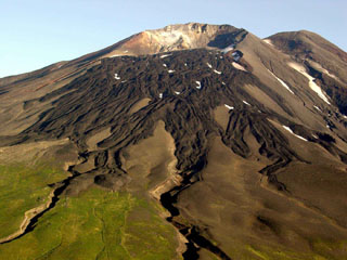
AVO raised the Volcano Alert Level for Gareloi to Advisory (the second level on a four-level scale) and the Aviation Color Code to Yellow (the second color on a four-color scale) at 1310 on 12 February due to increased seismic activity. Seismic unrest began at 0915 on 12 February; the local seismic network recorded ongoing tremor during 12-13 February. Persistent degassing activity from a fumarole field located on the S crater continued. No additional surficial activity was observed in partly cloudy satellite and webcam images.
Geological Summary. The 8 x 10 km Gareloi Island, the northernmost volcano of the Delarof Group at the western end of the Andreanof Islands, consists of a stratovolcano with two summits and a prominent SE-trending fissure. The fissure was formed during an eruption in 1929 and extends from the southern summit to the sea. Steep sea cliffs that are cut into rocks of an older, eroded center are found on the SW coast, and submarine deposits of three debris avalanches produced by edifice collapse are found offshore. Young lava flows cover the older volcano from the summit to the coast along three broad axes trending NW, ENE, and S. The 1929 eruption originated from 13 craters along a 4-km-long fissure. Phreatic explosions were followed by the ejection of glassy pumice, lapilli, scoria, and older blocks, as well as by the emission of four short, steep lava flows, one of which reached the SE coast.
Source: US Geological Survey Alaska Volcano Observatory (AVO)