Report on Fernandina (Ecuador) — 13 March-19 March 2024
Smithsonian Institution / US Geological Survey
Weekly Volcanic Activity Report, 13 March-19 March 2024
Managing Editor: Sally Sennert.
Please cite this report as:
Global Volcanism Program, 2024. Report on Fernandina (Ecuador) (Sennert, S, ed.). Weekly Volcanic Activity Report, 13 March-19 March 2024. Smithsonian Institution and US Geological Survey.
Fernandina
Ecuador
0.37°S, 91.55°W; summit elev. 1476 m
All times are local (unless otherwise noted)
IG-EPN reported that the eruption at Fernandina that began on 2 March occurred from about 20 circumferential fissures within an area 4.3 km long on the upper SE flank, between 1,000-1,200 m elevation. Multiple lava flows descended the SE flank; the longest lobe traveled SE then curved S, reaching about 750 m elevation, and having a total length of 8-9 km. Activity declined on 6 March and only Fissure 13 continued to effuse lava. The characterization of the activity level was changed from high to moderate on 13 March. The lava flows from Fissure 13 were active during 13-19 March based on thermal anomalies identified in satellite images, gas emissions, and photos shared by the Parque Nacional Galápagos. Sulfur dioxide emissions detected by satellite fluctuated between 576 and 1,133 tons per day.
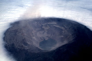
Geological Summary. Fernandina, the most active of Galápagos volcanoes and the one closest to the Galápagos mantle plume, is a basaltic shield volcano with a deep 5 x 6.5 km summit caldera. The volcano displays the classic "overturned soup bowl" profile of Galápagos shield volcanoes. Its caldera is elongated in a NW-SE direction and formed during several episodes of collapse. Circumferential fissures surround the caldera and were instrumental in growth of the volcano. Reporting has been poor in this uninhabited western end of the archipelago, and even a 1981 eruption was not witnessed at the time. In 1968 the caldera floor dropped 350 m following a major explosive eruption. Subsequent eruptions, mostly from vents located on or near the caldera boundary faults, have produced lava flows inside the caldera as well as those in 1995 that reached the coast from a SW-flank vent. Collapse of a nearly 1 km3 section of the east caldera wall during an eruption in 1988 produced a debris-avalanche deposit that covered much of the caldera floor and absorbed the caldera lake.
Source: Instituto Geofísico-Escuela Politécnica Nacional (IG-EPN)

