Report on Ruang (Indonesia) — 15 May-21 May 2024
Smithsonian Institution / US Geological Survey
Weekly Volcanic Activity Report, 15 May-21 May 2024
Managing Editor: Sally Sennert.
Please cite this report as:
Global Volcanism Program, 2024. Report on Ruang (Indonesia) (Sennert, S, ed.). Weekly Volcanic Activity Report, 15 May-21 May 2024. Smithsonian Institution and US Geological Survey.
Ruang
Indonesia
2.3058°N, 125.3671°E; summit elev. 703 m
All times are local (unless otherwise noted)
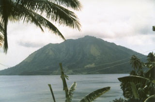
On 15 May BNPB reported that a total of 9,343 residents of Tagulandang and Ruang islands remained in evacuation centers because of eruptions from Ruang. According to PVMBG daily white steam-and-gas plumes that were sometimes dense rose as high as 700 m above the summit and drifted in multiple directions during 15-21 May. The Alert Level was lowered to 2 (the second lowest level on a scale of 1-4) at 0900 on 18 May and the public was warned to stay 2 km away from the active crater.
Geological Summary. Ruang volcano is the southernmost volcano in the Sangihe Island arc, north of Sulawesi Island; it is not the better known Raung volcano on Java. The 4 x 5 km island volcano is across a narrow strait SW of the larger Tagulandang Island. The summit contains a crater partially filled by a lava dome initially emplaced in 1904. Explosive eruptions recorded since 1808 have often been accompanied by lava dome formation and pyroclastic flows that have damaged inhabited areas.
Sources: Badan Nacional Penanggulangan Bencana (BNPB), Pusat Vulkanologi dan Mitigasi Bencana Geologi (PVMBG, also known as CVGHM)