Report on Nyamulagira (DR Congo) — 16 October-22 October 2024
Smithsonian Institution / US Geological Survey
Weekly Volcanic Activity Report, 16 October-22 October 2024
Managing Editor: Sally Sennert.
Written by Kadie L. Bennis.
Please cite this report as:
Global Volcanism Program, 2024. Report on Nyamulagira (DR Congo) (Bennis, K L, and Sennert, S, eds.). Weekly Volcanic Activity Report, 16 October-22 October 2024. Smithsonian Institution and US Geological Survey.
Nyamulagira
DR Congo
1.408°S, 29.2°E; summit elev. 3058 m
All times are local (unless otherwise noted)
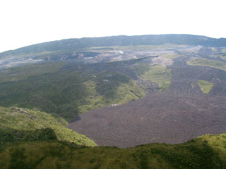
The Observatoire Volcanologique de Goma (OVG) reported that lava effusion at Nyamulagira was continuing. According to a special bulletin issued on 2 October, three lava flows were active on the N and W flanks, with the longest reaching 7 km NW from the crater rim. Strong seismicity in the area was also reported in a special bulletin issued on 14 October. During the nights of 13 and 14 October an intense glow was visible in the crater.
Geological Summary. Africa's most active volcano, Nyamulagira (also known as Nyamuragira), is a massive high-potassium basaltic shield about 25 km N of Lake Kivu and 13 km NNW of the steep-sided Nyiragongo volcano. The summit is truncated by a small 2 x 2.3 km caldera that has walls up to about 100 m high. Documented eruptions have occurred within the summit caldera, as well as from the numerous flank fissures and cinder cones. A lava lake in the summit crater, active since at least 1921, drained in 1938, at the time of a major flank eruption. Recent lava flows extend down the flanks more than 30 km from the summit as far as Lake Kivu; extensive lava flows from this volcano have covered 1,500 km2 of the western branch of the East African Rift.

