Report on Lewotobi (Indonesia) — 12 March-18 March 2025
Smithsonian Institution / US Geological Survey
Weekly Volcanic Activity Report, 12 March-18 March 2025
Managing Editor: Sally Sennert.
Please cite this report as:
Global Volcanism Program, 2025. Report on Lewotobi (Indonesia) (Sennert, S, ed.). Weekly Volcanic Activity Report, 12 March-18 March 2025. Smithsonian Institution and US Geological Survey.
Lewotobi
Indonesia
8.542°S, 122.775°E; summit elev. 1703 m
All times are local (unless otherwise noted)
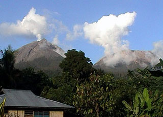
The Pusat Vulkanologi dan Mitigasi Bencana Geologi (PVMBG) reported that eruptive activity continued at Lewotobi Laki-laki during 12-18 March. Daily eruptive events produced gray ash plumes that rose as high as 2.5 km above the summit and drifted NE, N, NW, and W. According to a news article 1,841 people had not returned home since evacuating in November 2024 and were distributed across relatives' houses, rental houses, and government-provided field evacuation posts or temporary housing. The Alert Level remained at 3 (on a scale of 1-4) and the public was warned to stay 5 km away from the center of Laki-laki and 6 km in a semicircle clockwise from the SW to the NE.
Geological Summary. The Lewotobi edifice in eastern Flores Island is composed of the two adjacent Lewotobi Laki-laki and Lewotobi Perempuan stratovolcanoes (the "husband and wife"). Their summits are less than 2 km apart along a NW-SE line. The conical Laki-laki to the NW has been frequently active during the 19th and 20th centuries, while the taller and broader Perempuan has had observed eruptions in 1921 and 1935. Small lava domes have grown during the 20th century in both of the summit craters, which are open to the north. A prominent cone, Iliwokar, occurs on the E flank of Perampuan.
Sources: Pusat Vulkanologi dan Mitigasi Bencana Geologi (PVMBG, also known as CVGHM), Antara News