Fuego (Guatemala) | 12 March-18 March 2025 | New Activity / Unrest
 Cite this Report Cite this Report
|
 Fuego Fuego
Central America Volcanic Arc
|
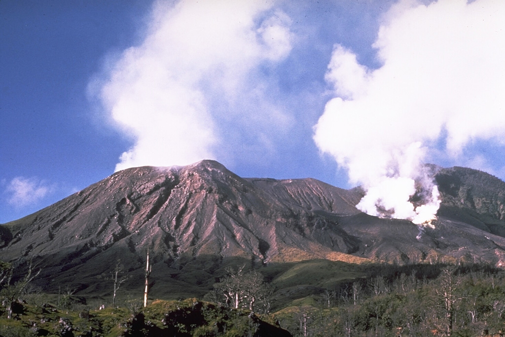
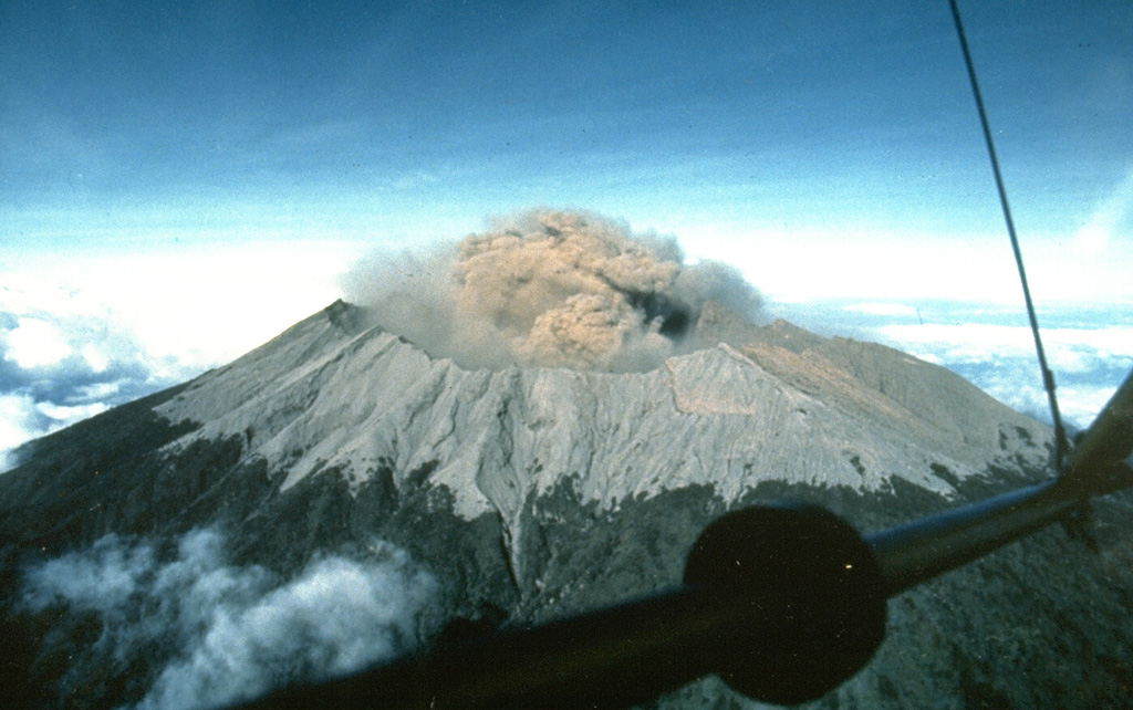
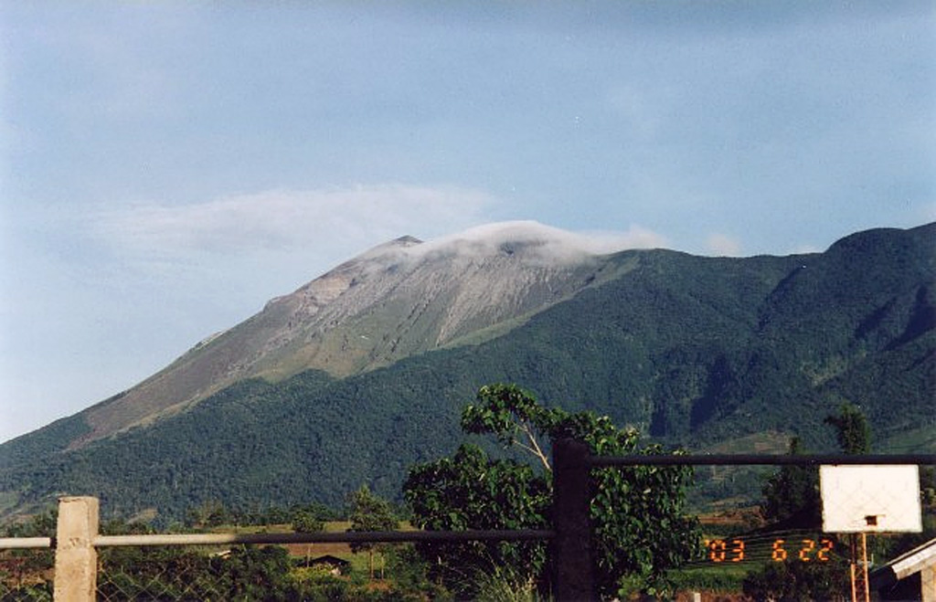
The Instituto Nacional de Sismología, Vulcanología, Meteorología e Hidrología (INSIVUMEH) reported that after the elevated eruptive activity at Fuego during 9-10 March, low-level unrest persisted through 18 March. Gas-and-steam plumes that were mostly diffuse rose as high as 700 m above the summit and drifted in multiple directions. Incandescence at the crater was sometimes visible during dark hours likely from blocks emplaced during the eruption.
Source: Instituto Nacional de Sismologia, Vulcanologia, Meteorologia, e Hidrologia (INSIVUMEH)
|
Langila (Papua New Guinea) | 12 March-18 March 2025 | New Activity / Unrest
Cite this Report
|
 Langila Langila
Bismarck Volcanic Arc
|
The Darwin Volcanic Ash Advisory Centre (VAAC) reported that an ash plume from Langila rose to 3 km (10,000 ft) a.s.l. at 1530 on 13 March and drifted S based on a pilot report; weather clouds obscured satellite views. A satellite image at 2210 indicated that the ash had dissipated.
Source: Darwin Volcanic Ash Advisory Centre (VAAC)
|
Lascar (Chile) | 12 March-18 March 2025 | New Activity / Unrest
Cite this Report
|
 Lascar Lascar
Central Andean Volcanic Arc
|
The Servicio Nacional de Geología y Minería (SERNAGEOMIN) reported continuing unrest at Láscar. A thermal anomaly in the crater detected on 16 March was the most intense anomaly recorded in the previous month. Other satellite data continued to show three zones of elevated temperatures in the crater. Whitish gas emissions persisted. The seismic network recorded a decrease of long-period earthquakes beginning in early February. The Alert Level remained at Yellow (the second lowest level on a four-color scale) and the public was warned to stay at least 1 km away from the crater.
Source: Servicio Nacional de Geología y Minería (SERNAGEOMIN)
|
Lewotolok (Indonesia) | 12 March-18 March 2025 | New Activity / Unrest
Cite this Report
|
 Lewotolok Lewotolok
Sunda Volcanic Arc
|
The Pusat Vulkanologi dan Mitigasi Bencana Geologi (PVMBG) reported that an eruption at Lewotolok was ongoing during 12-18 March. Daily white steam-and-gas plumes rose as high as 500 m above the summit and drifted in multiple directions. At 0700 on 14 March a white-and-gray ash plume rose about 400 m above the summit and drifted NW. At 1515 and 1559 on 15 March gray ash plumes rose 500 and 600 m above the summit and drifted NW and NE, respectively. Seismicity significantly increased during 16-17 March. The Alert Level remained at 2 (on a scale of 1-4) and the public was warned to stay 2 km away from the vent and 2.5 km away on the S, SE, and W flanks.
Source: Pusat Vulkanologi dan Mitigasi Bencana Geologi (PVMBG, also known as CVGHM)
|
Manam (Papua New Guinea) | 12 March-18 March 2025 | New Activity / Unrest
Cite this Report
|
 Manam Manam
Bismarck Volcanic Arc
|
The Darwin Volcanic Ash Advisory Centre (VAAC) reported that an ash plume from Manam was identified in a satellite image at 1230 on 15 March drifting NNW. The plume had dissipated by 1510.
Source: Darwin Volcanic Ash Advisory Centre (VAAC)
|
Poas (Costa Rica) | 12 March-18 March 2025 | New Activity / Unrest
Cite this Report
|
 Poas Poas
Central America Volcanic Arc
|
The Observatorio Vulcanológico y Sismológico de Costa Rica-Universidad Nacional (OVSICORI-UNA) reported that eruptive activity at Poás continued at an elevated level through 18 March. Four significant phreatic eruptions were recorded on 9 March that ejected material as high as 300 m above the lake’s surface and produced a steam-and-gas plume that rose 1 km. The monitoring network did not record eruptive events during 11-12 March. Sulfur dioxide emissions fluctuated; emissions detected in satellite data averaged 344 tons per day (t/d) on 11 March and 472 t/d on 12 March and relatively high concentrations were measured by a gas sensor located at the Visitor Observation Deck on 12 March. Residents in Grecia (16 km SW), Sarchí (18 km SW), and San Gertrudis (13 km SSW) reported a sulfur odor and minor ashfall.
A small phreatic eruption occurred at 0536 on 13 March, though continuous and voluminous emissions of steam and gas obscured views of the event. A sequence of small phreatic events was recorded during 1800-2000, culminating in a moderate phreatic eruption at 2000. A plume containing significant amounts of sulfur dioxide, hydrogen sulfide, and tephra drifted NW as far as the SW part of Nicaragua. Sulfur dioxide emissions detected in satellite data averaged 844 t/d. At 2300 instruments located at the visitor building of the Parque Nacional Volcán Poás recorded extreme levels of sulfur dioxide gas and particulates in the air; these conditions lasted until around 0300 on 14 March. During 0140-0200 on 14 March a gas monitoring station in San Isidro de Coronado measured high levels of sulfur dioxide gas from a plume that drifted S and E of the Valle Central. Residents of Heredia (28 km SE), Alajuela (21 km S), and San José (33 km SE) reported sulfur odors, minor ashfall, and adverse health effects like respiratory discomfort for both residents and animals. Gas-and-steam emissions continued from both Boca A and Boca C through 18 March. The Alert Level remained at 3 (the second highest level on a four-level scale) and the Aviation Color Code remained at Orange (the second highest color on a four-color scale).
Source: Observatorio Vulcanologico y Sismologico de Costa Rica-Universidad Nacional (OVSICORI-UNA)
|
Raung (Indonesia) | 12 March-18 March 2025 | New Activity / Unrest
Cite this Report
|
 Raung Raung
Sunda Volcanic Arc
|
The Pusat Vulkanologi dan Mitigasi Bencana Geologi (PVMBG) reported that a dense gray ash plume rose around 1.5 km above Raung’s summit crater rim and drifted W and NW at 0659 on 13 March. The Alert Level remained at 2 (on a scale of 1-4) and the public was warned to stay 3 km away from the summit crater.
Source: Pusat Vulkanologi dan Mitigasi Bencana Geologi (PVMBG, also known as CVGHM)
|
Turrialba (Costa Rica) | 12 March-18 March 2025 | New Activity / Unrest
Cite this Report
|
 Turrialba Turrialba
Central America Volcanic Arc
|
The Observatorio Vulcanológico y Sismológico de Costa Rica-Universidad Nacional (OVSICORI-UNA) reported that a small landslide in Turrialba’s West Crater produced a small ash plume at 1545 on 14 March.
Source: Observatorio Vulcanologico y Sismologico de Costa Rica-Universidad Nacional (OVSICORI-UNA)
|
Ahyi (United States) | 12 March-18 March 2025 | Continuing ActivityCite this Report |
 Ahyi Ahyi
Mariana Volcanic Arc
|
Unrest at Ahyi Seamount continued during 7-14 March. A few hydroacoustic detections coming from the direction of Ahyi were identified in data from underwater pressure sensors near Wake Island (about 2,270 km E of Ahyi). Weather clouds obscured satellite views of the seamount. The Aviation Color Code remained at Yellow (the second lowest level on a four-color scale) and the Volcano Alert Level remained at Advisory (the second lowest level on a four-level scale).
Source: US Geological Survey
|
Aira (Japan) | 12 March-18 March 2025 | Continuing ActivityCite this Report |
 Aira Aira
Ryukyu Volcanic Arc
|
The Japan Meteorological Agency (JMA) reported ongoing eruptive activity at Minamidake Crater (Aira Caldera’s Sakurajima volcano) during 10-17 March. Nightly crater incandescence was visible in webcam images during 10-14 March. An explosion at 1706 on 11 March generated an ash plume that rose 600 m straight up above the crater rim and merged into weather clouds. The explosion ejected large blocks 600-900 m from the vent. An eruptive event at 2027 on 13 March generated an ash plume that rose 1.2 km above the crater rim and drifted SW. An eruptive event at 1757 on 16 March generated an ash plume that rose 2.2 km above the crater rim. The Alert Level remained at 3 (on a 5-level scale), and the public was warned to stay 1 km away from both the Minimadake and Showa craters.
Source: Japan Meteorological Agency (JMA)
|
Bezymianny (Russia) | 12 March-18 March 2025 | Continuing ActivityCite this Report |
 Bezymianny Bezymianny
Eastern Kamchatka Volcanic Arc
|
The Kamchatkan Volcanic Eruption Response Team (KVERT) reported that a strong thermal anomaly over Bezymianny was identified in satellite images during 6-13 March. According to the Institute of Volcanology and Seismology (IVS) of the Far Eastern Branch of the Russian Academy of Sciences (FEB RAS), incandescent debris avalanches descended the SE and/or E flanks and daily summit incandescence was visible during dark hours. The summit incandescence and debris avalanches were intense mid-week. Ash plumes generated from debris avalanches rose as high as 1.1 km above the summit and drifted mainly E, NE, and SE. Weather conditions occasionally obscured webcam and satellite views. The Aviation Color Code remained at Orange (the second highest level on a four-color scale). Dates are reported in UTC; specific events are in local time where noted.
Sources: Kamchatkan Volcanic Eruption Response Team (KVERT), Institute of Volcanology and Seismology (IVS) of the Far Eastern Branch of the Russian Academy of Sciences (FEB RAS)
|
Dukono (Indonesia) | 12 March-18 March 2025 | Continuing ActivityCite this Report |
 Dukono Dukono
Halmahera Volcanic Arc
|
The Pusat Vulkanologi dan Mitigasi Bencana Geologi (PVMBG) reported that activity at Dukono was high during 2025. The monitoring network recorded a range of 60-394 daily eruptive events (227 events/day average), with ash-and-gas plumes rising 200-2,500 m above the summit. Rumbling and booming sounds were reported during 12-13 March. Daily gas-and-ash plumes during 12-18 March generally rose up to 2.5 km above the summit and drifted NW, W, and SW. Plumes on 16 March rose higher; at 1346 and at 1442 dense gray ash plumes rose 3-3.1 km above the crater rim that drifted W and NW. The Alert Level remained at Level 2 (on a scale of 1-4) and the public was warned to stay 4 km away from the Malupang Warirang Crater.
Source: Pusat Vulkanologi dan Mitigasi Bencana Geologi (PVMBG, also known as CVGHM)
|
Etna (Italy) | 12 March-18 March 2025 | Continuing ActivityCite this Report |
 Etna Etna
Sicily Volcanic Province
|
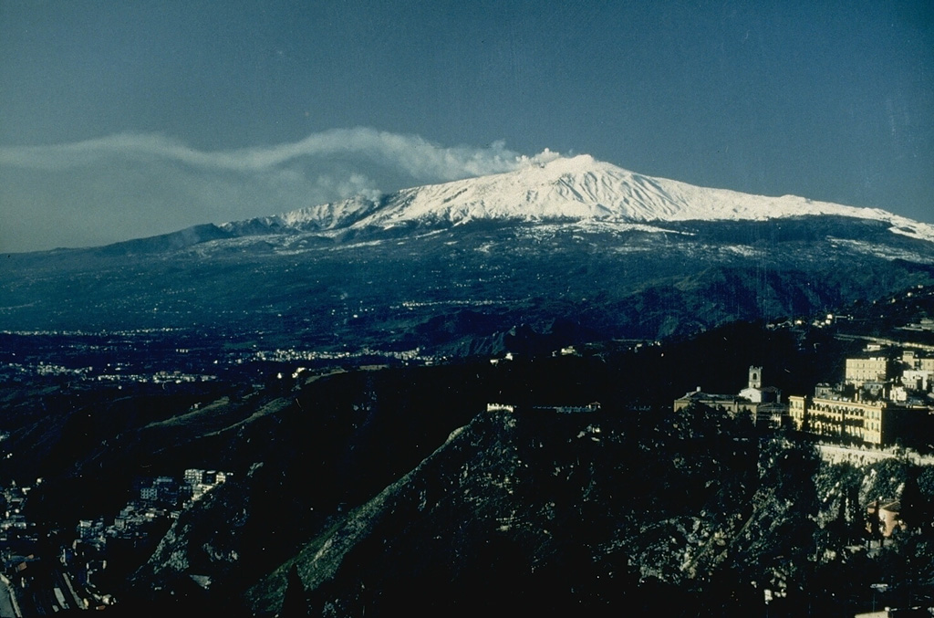
The Sezione di Catania - Osservatorio Etneo (INGV) reported continuing activity at Etna during 10-16 March. Weather clouds often obscured views of the summit area, though during a few clear periods gas emissions were observed rising from the summit craters. Strombolian activity at SE Crater resumed at 2018 on 15 March with incandescent ejecta staying inside the crater. The Aviation Color Code was raised to Yellow (the second lowest level on a four-color scale) at 2032 and then to Orange at 2047. Activity intensified at around 0000 on 16 March and incandescent material fell onto the flanks as far as the base of the crater. The activity peaked at 0115, began declining at 0215, and ceased at 0320. The Aviation Color Code was lowered to Yellow and then Green at 0841 and 1642, respectively, on 17 March.
Source: Sezione di Catania - Osservatorio Etneo (INGV)
|
Great Sitkin (United States) | 12 March-18 March 2025 | Continuing ActivityCite this Report |
 Great Sitkin Great Sitkin
Aleutian Ridge Volcanic Arc
|
The Alaska Volcano Observatory (AVO) reported that slow lava effusion continued to feed a thick flow in Great Sitkin’s summit crater during 12-18 March. Small daily earthquakes were detected by the seismic network. Weather clouds often obscured satellite and webcam views of the volcano. Satellite images showed steaming at the lava flow during 16-17 March and lava advancement to the NE and E during 16-18 March. The Volcano Alert Level remained at Watch (the third level on a four-level scale) and the Aviation Color Code remained at Orange (the third color on a four-color scale).
Source: US Geological Survey Alaska Volcano Observatory (AVO)
|
Ibu (Indonesia) | 12 March-18 March 2025 | Continuing ActivityCite this Report |
 Ibu Ibu
Halmahera Volcanic Arc
|
The Pusat Vulkanologi dan Mitigasi Bencana Geologi (PVMBG) reported that the eruption at Ibu continued during 12-18 March. Multiple daily dense gray ash plumes rose as high as 1.2 km above the summit and drifted in multiple directions. Very minor incandescence at the summit was visible in a few webcam images posted with the reports. The Alert Level remained at 3 (the second highest level on a four-level scale) and the public was advised to stay 4 km away from the active crater and 5 km away from the N crater wall opening.
Source: Pusat Vulkanologi dan Mitigasi Bencana Geologi (PVMBG, also known as CVGHM)
|
Kanlaon (Philippines) | 12 March-18 March 2025 | Continuing ActivityCite this Report |
 Kanlaon Kanlaon
Negros-Sulu Volcanic Arc
|
The Philippine Institute of Volcanology and Seismology (PHIVOLCS) reported continuing eruptive activity at Kanlaon during 11-17 March. The seismic network recorded 6-21 daily volcanic earthquakes. Average daily sulfur dioxide emissions ranged from 1,712 to 4,065 tonnes per day. Gas-and-steam emissions that were often continuous and occasionally contained ash rose as high as 200 m above the summit and drifted W and SW. A period of ash emissions during 1526-1624 on 12 March produced grayish plumes that rose 50 m above the crater rim and drifted SW. The Alert Level remained at 3 (on a scale of 0-5); the public was warned to stay 6 km away from the summit and pilots were warned not to fly close to the volcano.
Source: Philippine Institute of Volcanology and Seismology (PHIVOLCS)
|
Karymsky (Russia) | 12 March-18 March 2025 | Continuing ActivityCite this Report |
 Karymsky Karymsky
Eastern Kamchatka Volcanic Arc
|
The Kamchatkan Volcanic Eruption Response Team (KVERT) reported moderate levels of activity at Karymsky during 6-13 March. Thermal anomalies over the volcano were identified in satellite images during 6, 9, and 11-13 March; weather clouds obscured views on the other days. The Aviation Color Code remained at Orange (the third level on a four-color scale). Dates are based on UTC times; specific events are in local time where noted.
Source: Kamchatkan Volcanic Eruption Response Team (KVERT)
|
Katmai (United States) | 12 March-18 March 2025 | Continuing ActivityCite this Report |
 Katmai Katmai
Alaska Peninsula Volcanic Arc
|
The Alaska Volcano Observatory (AVO) reported that on 16 March strong winds in the vicinity of Katmai and the Valley of Ten Thousand Smokes dispersed unconsolidated ash up to 1.8 km (6,000 ft) a.s.l. to the SE. The ash was originally deposited during the Novarupta-Katmai eruption in 1912. The Volcano Alert Level remained at Normal (the lowest level on a four-level scale) and the Aviation Color Code remained at Green (the lowest level on a four-color scale).
Source: US Geological Survey Alaska Volcano Observatory (AVO)
|
Kilauea (United States) | 12 March-18 March 2025 | Continuing ActivityCite this Report |
 Kilauea Kilauea
Hawaiian-Emperor Hotspot Volcano Group
|
The Hawaiian Volcano Observatory (HVO) reported that the eruption within Kilauea’s Kaluapele summit caldera, from vents along the SW margin of Halema’uma’u Crater, continued at variable levels during 11-18 March. Small, sporadic, spatter fountains began at the N vent at about 0130 on 10 March and continued into 11 March. Lava flows emerged from the N vent at 0236 on 11 March and tall fountaining started 10 minutes later; by 0330 the fountains had reached 120-150 m and by 0400 they were over 180 m tall. Lava effusion at the S vent began at 0312 and fountaining began at 0330. Lava fountains from both vents continued through the day, rising 140-160 m. Sulfur dioxide emission averaged approximately 40,000 tonnes per day (t/d) during the period of high fountaining and Pele’s Hair was reported in Pahala, 40 km SW. Fountaining ceased at 1511 at the N vent and at 1513 at the S vent. Lava flows covered more than two-thirds of the crater floor. By 1700 sulfur dioxide emissions had decreased to an average of 3,000 t/d. Gas emissions and incandescence from both vents were visible during 12-18 March. Lava flows unrelated to activity at the N and S vents continue to spread across the down-dropped block on the E side of Halema’uma’u, likely fed by magma previously intruded beneath the crater floor. The Volcano Alert Level remained at Watch (the third level on a four-level scale) and the Aviation Color Code remained at Orange (the third color on a four-color scale).
Source: US Geological Survey Hawaiian Volcano Observatory (HVO)
|
Lewotobi (Indonesia) | 12 March-18 March 2025 | Continuing ActivityCite this Report |
 Lewotobi Lewotobi
Sunda Volcanic Arc
|
The Pusat Vulkanologi dan Mitigasi Bencana Geologi (PVMBG) reported that eruptive activity continued at Lewotobi Laki-laki during 12-18 March. Daily eruptive events produced gray ash plumes that rose as high as 2.5 km above the summit and drifted NE, N, NW, and W. According to a news article 1,841 people had not returned home since evacuating in November 2024 and were distributed across relatives' houses, rental houses, and government-provided field evacuation posts or temporary housing. The Alert Level remained at 3 (on a scale of 1-4) and the public was warned to stay 5 km away from the center of Laki-laki and 6 km in a semicircle clockwise from the SW to the NE.
Sources: Pusat Vulkanologi dan Mitigasi Bencana Geologi (PVMBG, also known as CVGHM), Antara News
|
Marapi (Indonesia) | 12 March-18 March 2025 | Continuing ActivityCite this Report |
 Marapi Marapi
Sunda Volcanic Arc
|
The Pusat Vulkanologi dan Mitigasi Bencana Geologi (PVMBG) reported that eruptive activity at Marapi (on Sumatra) continued during 12-18 March. White plumes generally rose as high as 300 m above the summit and drifted in multiple directions on most days. An eruptive event was recorded at 0755 on 13 March but not visually observed due to weather conditions. At 0700 on 16 March and at 1120 on 17 March dense gray ash plumes rose 800 m and 600 m above the summit and drifted N and NW, respectively. The Alert Level remained at 2 (on a scale of 1-4) and the public was warned to stay 3 km away from the active crater.
Source: Pusat Vulkanologi dan Mitigasi Bencana Geologi (PVMBG, also known as CVGHM)
|
Merapi (Indonesia) | 12 March-18 March 2025 | Continuing ActivityCite this Report |
 Merapi Merapi
Sunda Volcanic Arc
|
The Balai Penyelidikan dan Pengembangan Teknologi Kebencanaan Geologi (BPPTKG) reported that the eruption at Merapi (on Java) continued during 7-13 March. Seismicity remained at high levels. The SW lava dome produced 54 lava avalanches that traveled as far as 2 km SW down the Bebeng drainage, 33 that traveled as far as 2 km SW down the Krasak drainage, and 31 that traveled as far as 2 km W down the Sat/Putih drainage. Slight morphological changes to the SW lava dome resulted from minor collapses of material. The hottest temperature was 248.5 degrees Celsius, and the volume was an estimated 3,626,200 cubic meters, based on webcam images and an 11 March drone survey. The Alert Level remained at 3 (on a scale of 1-4), and the public was warned to stay 3-7 km away from the summit, based on location.
Source: Balai Penyelidikan dan Pengembangan Teknologi Kebencanaan Geologi (BPPTKG)
|
Reventador (Ecuador) | 12 March-18 March 2025 | Continuing ActivityCite this Report |
 Reventador Reventador
Northern Andean Volcanic Arc
|
The Instituto Geofísico-Escuela Politécnica Nacional (IG-EPN) reported that eruptive activity continued at Reventador during 11-18 March. Seismicity included 59-106 daily explosions, long-period earthquakes, harmonic tremor, and tremor associated with emissions. Multiple daily ash-and-gas plumes rose as high as 1.1 km above the crater rim and drifted in multiple directions. Webcams recorded multiple instances nightly of incandescent material descending the flanks as far as 900 m below the crater rim. Minor ashfall was reported in Piedra Fina, 8 km SE, at around 0700 on 14 March; ashfall in that area had been persistent for the past few months. On 17 March a pyroclastic flow traveled 400 m down the SE flank. Incandescent material was ejected 400 m above the crater rim. Secretaría de Gestión de Riesgos maintained the Alert Level at Orange (the second highest level on a four-color scale).
Sources: Instituto Geofísico-Escuela Politécnica Nacional (IG-EPN), Secretaría de Gestión de Riesgos (SGR)
|
Rincon de la Vieja (Costa Rica) | 12 March-18 March 2025 | Continuing ActivityCite this Report |
 Rincon de la Vieja Rincon de la Vieja
Central America Volcanic Arc
|
The Observatorio Vulcanologico y Sismologico de Costa Rica-Universidad Nacional (OVSICORI-UNA) reported that occasional, small, phreatic eruptions at Rincón de la Vieja were recorded during 12-17 March in monitoring network data. A phreatic eruption at 1828 on 13 March was preceded by more than 25 tornillo-type seismic events. A phreatic event at 0344 on 14 March was the most energetic so far in 2025 and produced a voluminous steam-and-gas plume with tephra that drifted SW.
Source: Observatorio Vulcanologico y Sismologico de Costa Rica-Universidad Nacional (OVSICORI-UNA)
|
Sangay (Ecuador) | 12 March-18 March 2025 | Continuing ActivityCite this Report |
 Sangay Sangay
Northern Andean Volcanic Arc
|
The Instituto Geofísico-Escuela Politécnica Nacional (IG-EPN) reported that moderate levels of eruptive activity continued at Sangay during 11-18 March. The seismic network recorded 78-475 daily explosions. Weather clouds obscured views most of the week, but during 16-17 March several gas-and-ash plumes were visible rising as high as 1 km above the summit and drifting W, WSW, and SW. Secretaría de Gestión de Riesgos (SGR) maintained the Alert Level at Yellow (the second highest level on a four-color scale).
Sources: Instituto Geofísico-Escuela Politécnica Nacional (IG-EPN), Secretaría de Gestión de Riesgos (SGR)
|
Santa Maria (Guatemala) | 12 March-18 March 2025 | Continuing ActivityCite this Report |
 Santa Maria Santa Maria
Central America Volcanic Arc
|
The Instituto Nacional de Sismología, Vulcanología, Meteorología e Hidrología (INSIVUMEH) reported ongoing, high-level eruptive activity at Santa Maria’s Santiaguito dome complex during 11-18 March with continuing lava extrusion at Caliente dome. Daily explosions, as many as seven per hour when reported, generated gas-and-ash plumes that rose as high as 1.2 km above the dome and possibly drifted as far as 40 km S, SW, W, and NE. Effusion of blocky lava and collapses of material produced block avalanches that were sometimes heard several kilometers away; these mainly descended the SW and S flanks. Collapsed material sometimes produced short pyroclastic flows that descended the flanks in all directions. Incandescence was visible at the crater and upper part of the SW flank lava flow. Ashfall was forecast for areas downwind on most days.
Source: Instituto Nacional de Sismologia, Vulcanologia, Meteorologia, e Hidrologia (INSIVUMEH)
|
Semeru (Indonesia) | 12 March-18 March 2025 | Continuing ActivityCite this Report |
 Semeru Semeru
Sunda Volcanic Arc
|
The Pusat Vulkanologi dan Mitigasi Bencana Geologi (PVMBG) reported that activity continued at Semeru during 12-18 March, with multiple, daily eruptive events recorded by the seismic network. Daily white-and-gray or gray ash plumes rose 500-1,200 m above the summit and drifted in multiple directions. The Alert Level remained at 2 (the second lowest level on a scale of 1-4). The public was warned to stay at least 5 km away from the summit in all directions, 13 km from the summit to the SE, 500 m from the banks of the Kobokan drainage as far as 17 km from the summit, and to avoid other drainages including the Bang, Kembar, and Sat, due to lahar, avalanche, and pyroclastic flow hazards.
Source: Pusat Vulkanologi dan Mitigasi Bencana Geologi (PVMBG, also known as CVGHM)
|
Sheveluch (Russia) | 12 March-18 March 2025 | Continuing ActivityCite this Report |
 Sheveluch Sheveluch
Eastern Kamchatka Volcanic Arc
|
The Kamchatkan Volcanic Eruption Response Team (KVERT) reported that lava extrusion may have continued at Sheveluch’s “300 years of RAS” dome on the SW flank of Old Sheveluch and at the Young Sheveluch dome during 6-13 March. Daily thermal anomalies over the domes were identified in satellite images. The Aviation Color Code remained at Orange (the second highest level on a four-color scale). Dates are based on UTC times; specific events are in local time where noted.
Source: Kamchatkan Volcanic Eruption Response Team (KVERT)
|
Spurr (United States) | 12 March-18 March 2025 | Continuing ActivityCite this Report |
 Spurr Spurr
Alaska Peninsula Volcanic Arc
|
The Alaska Volcano Observatory (AVO) reported increasing unrest at Spurr in a special information statement issued on 12 March. Collapses of snow and ice into the summit crater lake that formed during the current period of unrest continued to occur along with steam emissions from fumaroles within and around the summit crater. New diffuse steam plumes from small snow-free spots within Crater Peak, a vent 3.5 km S of the summit, were first observed on 6 March. These locations have been sporadically snow-free for years, but steaming had not been observed since 2008. Significantly elevated volcanic gas emissions were measured during overflights on 7 and 11 March, when newly reactivated fumaroles at Crater Peak were also observed. About 450 tons per day (t/d) of sulfur dioxide at the summit crater was measured on 7 March, an increase from less than 50 t/d measured in December 2024. Notably high concentrations of carbon dioxide detected at Crater Peak are similar to values measured before other eruptions such as Redoubt in 2009. An average of 100 earthquakes per week were located during the past month; most were shallow, around 4 km below sea level, with the largest being M 2.7. Over 3,400 earthquakes had been located since April 2024. Ground deformation continued to be detected with a total of about 6.5 cm of inflation recorded at the closest Global Navigation Satellite System (GNSS) station. Modeling of the data suggested that the source was located 3-5 km below sea level and 3-4 km W of the summit. Seismicity remained elevated during 13-18 March with numerous small, shallow volcanic earthquakes detected beneath the volcano. Weather clouds often obscured views, though the crater lake and a gas plume were visible on 15 March, and a small steam plume rising from the summit was observed in clear webcam and satellite images during 17-18 March.
The interpretation from AVO is that a magmatic intrusion has been underway for months, and the recent gas data suggests that a new pathway towards the Crater Peak vent has opened; Crater Peak erupted in 1953 and 1992 and the summit last erupted several thousand years ago. The Volcano Alert Level remained at Advisory (the second lowest level on a four-level scale) and the Aviation Color Code remained at Yellow (the second lowest level on a four-color scale).
Source: US Geological Survey Alaska Volcano Observatory (AVO)
|
Stromboli (Italy) | 12 March-18 March 2025 | Continuing ActivityCite this Report |
 Stromboli Stromboli
Aeolian Volcanic Arc
|
The Sezione di Catania - Osservatorio Etneo (INGV) reported that eruptive activity continued at Stromboli during 10-16 March. Webcam images showed Strombolian activity at four vents in Area N within the upper part of the Sciara del Fuoco and from at least two vents in Area C-S (South-Central Crater) on the crater terrace. The vents in Area N continued to produce low- to medium-intensity explosions at a rate of 4-9 events per hour, ejecting lapilli and bombs less than 150 m above the vents. Explosions at the vents in Area C-S ejected tephra above the vent at a rate of 1-4 events per hour. The Alert Level remained at Yellow (the second lowest level on a four-level scale).
Source: Sezione di Catania - Osservatorio Etneo (INGV)
|
Suwanosejima (Japan) | 12 March-18 March 2025 | Continuing ActivityCite this Report |
 Suwanosejima Suwanosejima
Ryukyu Volcanic Arc
|
The Japan Meteorological Agency (JMA) reported that eruptive activity at Suwanosejima's Ontake Crater continued during 10-17 March. Incandescence was observed nightly in webcam images. Eruptive activity generated emissions that rose 900 m above the crater rim. The Alert Level remained at 2 (the second level on a five-level scale) and the public was warned to stay at least 1.5 km away from the crater.
Source: Japan Meteorological Agency (JMA)
|
