Report on Lascar (Chile) — 12 March-18 March 2025
Smithsonian Institution / US Geological Survey
Weekly Volcanic Activity Report, 12 March-18 March 2025
Managing Editor: Sally Sennert.
Please cite this report as:
Global Volcanism Program, 2025. Report on Lascar (Chile) (Sennert, S, ed.). Weekly Volcanic Activity Report, 12 March-18 March 2025. Smithsonian Institution and US Geological Survey.
Lascar
Chile
23.37°S, 67.73°W; summit elev. 5592 m
All times are local (unless otherwise noted)
The Servicio Nacional de Geología y Minería (SERNAGEOMIN) reported continuing unrest at Láscar. A thermal anomaly in the crater detected on 16 March was the most intense anomaly recorded in the previous month. Other satellite data continued to show three zones of elevated temperatures in the crater. Whitish gas emissions persisted. The seismic network recorded a decrease of long-period earthquakes beginning in early February. The Alert Level remained at Yellow (the second lowest level on a four-color scale) and the public was warned to stay at least 1 km away from the crater.
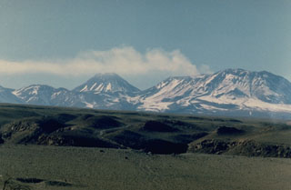
Geological Summary. Láscar is the most active volcano of the northern Chilean Andes. The andesitic-to-dacitic stratovolcano contains six overlapping summit craters. Prominent lava flows descend its NW flanks. An older, higher stratovolcano 5 km E, Volcán Aguas Calientes, displays a well-developed summit crater and a probable Holocene lava flow near its summit (de Silva and Francis, 1991). Láscar consists of two major edifices; activity began at the eastern volcano and then shifted to the western cone. The largest eruption took place about 26,500 years ago, and following the eruption of the Tumbres scoria flow about 9000 years ago, activity shifted back to the eastern edifice, where three overlapping craters were formed. Frequent small-to-moderate explosive eruptions have been recorded since the mid-19th century, along with periodic larger eruptions that produced ashfall hundreds of kilometers away. The largest historical eruption took place in 1993, producing pyroclastic flows to 8.5 km NW of the summit and ashfall in Buenos Aires.
Source: Servicio Nacional de Geología y Minería (SERNAGEOMIN)

