Report on Lewotolok (Indonesia) — 26 March-1 April 2025
Smithsonian Institution / US Geological Survey
Weekly Volcanic Activity Report, 26 March-1 April 2025
Managing Editor: Sally Sennert.
Please cite this report as:
Global Volcanism Program, 2025. Report on Lewotolok (Indonesia) (Sennert, S, ed.). Weekly Volcanic Activity Report, 26 March-1 April 2025. Smithsonian Institution and US Geological Survey.
Lewotolok
Indonesia
8.274°S, 123.508°E; summit elev. 1431 m
All times are local (unless otherwise noted)
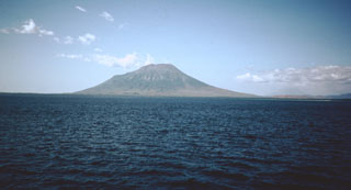
The Pusat Vulkanologi dan Mitigasi Bencana Geologi (PVMBG) reported that an eruption at Lewotolok was ongoing during 26 March-1 April. White steam-and-gas plumes rose 100 m above the summit and drifted E on 26 March. Weather conditions obscured views during 27-30 March, though a nighttime webcam image on 29 March showed incandescent material being ejected above the summit. On 31 March white-and-gray ash plumes rose 100 m and drifted E and SE; a nighttime webcam image again showed incandescent material being ejected above the summit. The Alert Level remained at 2 (on a scale of 1-4) and the public was warned to stay 2 km away from the vent and 2.5 km away on the S, SE, and W flanks.
Geological Summary. The Lewotolok (or Lewotolo) stratovolcano occupies the eastern end of an elongated peninsula extending north into the Flores Sea, connected to Lembata (formerly Lomblen) Island by a narrow isthmus. It is symmetrical when viewed from the north and east. A small cone with a 130-m-wide crater constructed at the SE side of a larger crater forms the volcano's high point. Many lava flows have reached the coastline. Eruptions recorded since 1660 have consisted of explosive activity from the summit crater.
Source: Pusat Vulkanologi dan Mitigasi Bencana Geologi (PVMBG, also known as CVGHM)