Report on Katmai (United States) — 2 April-8 April 2025
Smithsonian Institution / US Geological Survey
Weekly Volcanic Activity Report, 2 April-8 April 2025
Managing Editor: Sally Sennert.
Please cite this report as:
Global Volcanism Program, 2025. Report on Katmai (United States) (Sennert, S, ed.). Weekly Volcanic Activity Report, 2 April-8 April 2025. Smithsonian Institution and US Geological Survey.
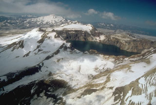
Katmai
United States
58.279°N, 154.9533°W; summit elev. 2047 m
All times are local (unless otherwise noted)
The Alaska Volcano Observatory (AVO) reported that during 6-7 and 9 April strong winds in the vicinity of Katmai and the Valley of Ten Thousand Smokes dispersed unconsolidated ash up to 1.5-1.8 km (5,000-6,000 ft) a.s.l. to the SE. The ash was originally deposited during the Novarupta-Katmai eruption in 1912. The Volcano Alert Level remained at Normal (the lowest level on a four-level scale) and the Aviation Color Code remained at Green (the lowest level on a four-color scale).
Geological Summary. Katmai was initially considered to be the source of the Valley of Ten Thousand Smokes ash flow in 1912. However, the 3 x 4 km caldera of 1912 is now known to have formed as a result of the voluminous eruption at nearby Novarupta volcano. The edifice had four NE-SW-trending summits, most of which were truncated by the 1912 collapse. Two or more large explosive eruptions took place during the late Pleistocene. Most of the two overlapping pre-1912 Katmai volcanoes are Pleistocene, but Holocene lava flows from a flank vent descend the SE flank of the SW edifice into the Katmai River canyon. The steep walled young caldera has a jagged rim that rises 500-1,000 m above the caldera floor and contains a deep lake. Lake waters have covered a small post-collapse lava dome (Horseshoe Island) that was seen on the caldera floor at the time of the initial ascent to the caldera rim in 1916.
Source: US Geological Survey Alaska Volcano Observatory (AVO)