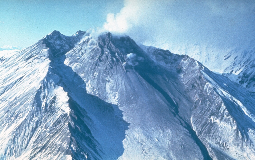
Kanlaon (Philippines) | 2 April-8 April 2025 | New Activity / Unrest
 Cite this Report Cite this Report
|
 Kanlaon Kanlaon
Negros-Sulu Volcanic Arc
|
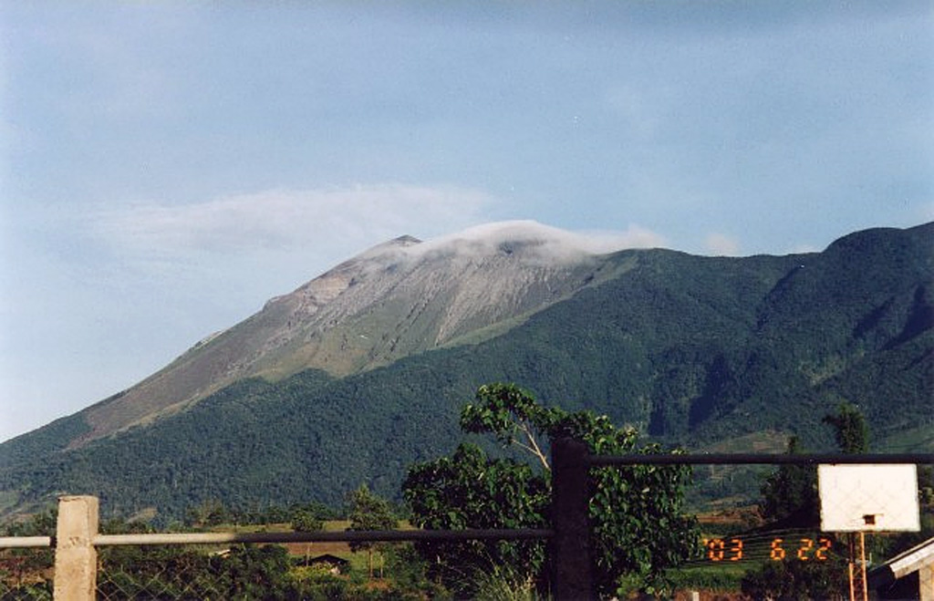
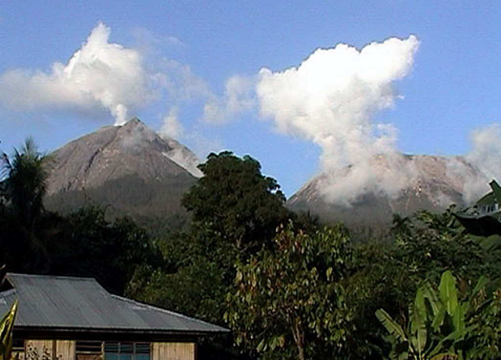
The Philippine Institute of Volcanology and Seismology (PHIVOLCS) reported continuing eruptive activity at Kanlaon during 1-7 April and a notable explosion on 8 April. The seismic network recorded 2-23 daily volcanic earthquakes, including 2-9 daily (except for 6 April) periods of volcanic tremor lasting two minutes to two hours and five minutes. Average daily sulfur dioxide emissions ranged from 1,283 to 2,725 tonnes per day. Moderate-to-voluminous gas-and-steam emissions that occasionally contained ash rose 100-600 m crater rim and drifted W, WSW, and SW. There were 2-9 periods of ash emissions during 1-5 April that each lasted 3 minutes to two minutes to two hours and five minutes.
A moderately explosive eruption occurred at 0551 on 8 April and lasted for 56 minutes based on seismic data and visual observations. A voluminous gray ash plume slowly rose 4 km above the crater rim and drifted W and SW. Rumbling was heard and pyroclastic density currents traveled 1 km down the S flank. Large ballistic fragments were ejected a few hundred meters and set vegetation on fire on the upper E flank, near the summit. Minor ashfall was reported in the barangays including Roberto Salas Benedicto, La Granja, Haguimit, Nagasi, Yubo, Ara-al, San Miguel, and Cubay (La Carlota City), Mailum, Ilijan, and Binubuhan (Bago City), and Sag-ang and Mansalanao (La Castellana). Sulfur odors were notable in Cubay and less notable in areas as far as the Municipality of Hinigaran. According to a news article ashfall was widespread and recorded as far as 195 km W. About six domestic flights and one bound for Singapore were canceled. The Office of Civil Defense government offices, except those involved in disaster and emergency response, closed in La Carlota City along with face-to-face classes at all levels. Private establishments were encouraged to suspend work. Heavy ashfall in Ara-al within an hour of the eruption caused poor road visibility, and the river at the Najalin Bridge between Cubay and La Granja was contaminated with ashfall and there was poor visibly along the road in that area as well. Many of the residents that had evacuated within a 6-km radius due to increased eruptive activity in December 2024 remained in evacuation centers or elsewhere; the Disaster Response Operations Monitoring and Information Center (DROMIC) reported that as of 1800 on 19 April there were 8,315 people (2,607 families) spread across 22 evacuation centers and another 11,892 people (3,702 families) staying elsewhere. The Alert Level remained at 3 (on a scale of 0-5); the public was warned to stay 6 km away from the summit and pilots were warned not to fly close to the volcano.
Sources: Philippine Institute of Volcanology and Seismology (PHIVOLCS), Office of Civil Defense, Republic of the Philippines, Disaster Response Operations Monitoring and Information Center (DROMIC), CBS News
|
Poas (Costa Rica) | 2 April-8 April 2025 | New Activity / Unrest
Cite this Report
|
 Poas Poas
Central America Volcanic Arc
|
The Observatorio Vulcanológico y Sismológico de Costa Rica-Universidad Nacional (OVSICORI-UNA) reported elevated levels of activity at Poás during 2-8 April. Inflation continued to be detected, though the rate of uplift had slowed. Sulfur dioxide emissions remained high; values over 2,200 tonnes per day (t/d) were identified in satellite data on 30 March and were followed by two days of values exceeding 1,000 t/d. Emissions recorded by a mobile Differential Optical Absorption Spectroscopy (DOAS) instrument averaged 5,300 ± 500 t/d on 1 April.
Phreatomagmatic events at Boca C occurred about every 4-12 minutes on most days during the week. The events produced almost continuous gas, steam, and ash plumes that generally rose up to 500 m and mostly drifted SE, S, SW, W, and NW, though the plumes occasionally rose higher. Notably, gas, steam, and ash plumes rose to 1 km on 29 March, to 3 km at 1252 on 4 April, to heights greater than 1 km at 1701 on 6 April and at 0203 on 7 April, and to 1.5 km at 0218 and 0224 on 8 April. Ashfall was reported by residents through the week; ashfall occurred on 4 April in Bajos del Toro (7 km WNW) and in areas to the S on 8 April including Poasito (7 km SW), San Juan Norte (9 km S), Savana Redonda (10 km SSE), San Pedro de Poás (14 km S), Poás (14 km S), Chilamate (16 km SSW), Pavas (16 km SE), Sabanilla (14 km SSE), Calle el Sitio 14 km S), Naranjo (16 km WSW), Cabuyal (8 km SW), Chilamate (16 km SSW), and Alajuela (20 km S). Explosions sometimes ejected incandescent blocks onto the crater floor. Weather conditions sometimes obscured views of the crater.
According to the Comisión Nacional de Emergencias (CNE) on 8 April the Alert Level Orange for the Parque Nacional volcán Poás remained in effect as well as for the district of Toro Amarillo in the Canton of Sarchí due to activity at the crater, ashfall and sulfur odors impacting areas downwind, and a higher potential of lahars in drainages. The volcano’s Alert Level remained at 3 (the second highest level on a four-level scale) and the Aviation Color Code remained at Orange (the second highest color on a four-color scale).
Sources: Observatorio Vulcanologico y Sismologico de Costa Rica-Universidad Nacional (OVSICORI-UNA), Comisión Nacional de Prevención de Riesgos y Atención de Emergencias (CNE)
|
Reykjanes (Iceland) | 2 April-8 April 2025 | New Activity / Unrest
Cite this Report
|
 Reykjanes Reykjanes
Iceland Neovolcanic Rift Volcanic Province
|
The Icelandic Meteorological Office (IMO) reported that the eruption that began at 0945 on 1 April near the Sundhnúkur crater row, located between Stóra-Skógfell and Sýlingarfell within the Reykjanes volcanic system, was over at 1645 on that same day. Data collected during an overflight conducted by the Icelandic Institute of Natural History on 1 April indicated that about 0.4 million cubic meters of lava had erupted, making it the smallest eruption of the series that began in December 2023 and one sixth of the volume of the second smallest eruption that occurred in January 2024. The flow field was about 0.23 square kilometers and had an average thickness of 1.7 m. Some incandescence on the flow field was visible during 1-2 April as lava cooled. More than 25 cm of subsidence was detected at a GPS station in Svartsengi, though by 1450 on 2 April the rate had significantly slowed. Minor seismicity continued to be recorded, though the earthquake magnitudes had decreased. Several GPS stations recorded at most about 50 cm of movement or displacement in Grindavík, spread over several cracks visible throughout the town. At 1212 on 3 April the Aviation Color Code was lowered to Yellow (the second lowest level on a four-color scale). Subsidence was no longer measured. Deformation data indicated that the northernmost part of the intrusion, about 4 km N of Keilur, remained active, and inflation resumed in Svartsengi, during 3-4 April, though seismicity was decreasing.
Source: Icelandic Meteorological Office (IMO)
|
Ulawun (Papua New Guinea) | 2 April-8 April 2025 | New Activity / Unrest
Cite this Report
|
 Ulawun Ulawun
Bismarck Volcanic Arc
|
The Rabaul Volcano Observatory (RVO) reported that activity at Ulawun was low during 1-7 April. Summit emissions were characterized as white, having variable densities, and containing small amounts of ash. The plumes drifted S and caused minor ashfall in areas within a few kilometers to the S and SW of the volcano. Low rumbling noises were heard in those same areas on 1 and 4 April. Seismicity generally remained low. The seismic station (UULA), 2.8 km from the summit on the lower WSW flank, recorded small low- and high-frequency volcanic earthquakes, with low-frequency earthquakes being the dominant signal. Starting at about 0800 on 4 April the seismic signals quickly changed to continuous volcanic tremor and the tremor amplitude grew relatively rapidly. The tremor lasted about 5.5 hours, reverting to discrete seismic signals at around 1720. The station ceased being operational at around 1900. The two other seismic stations, UALB (5.6 km) and UULB (10 km NW), did not detect the seismicity due to their distance from the volcano and high levels of cultural noise that obscured signals. RVO noted that a team from the West New Britain Provincial Disaster Office had been conducting community awareness activities within 10 km of Ulawun since 27 March, so far visiting the Ulamona area (10 km NW), Navo, Noau, Voluvolu, Bakada, Sabalbala, Vamakuma, Bago, Kabaia, Soi, and Sohula care center.
Source: Rabaul Volcano Observatory (RVO)
|
Ahyi (United States) | 2 April-8 April 2025 | Continuing ActivityCite this Report |
 Ahyi Ahyi
Mariana Volcanic Arc
|
Unrest at Ahyi Seamount may have continued during 28 March-5 April. A diffuse plume of discolored water in the vicinity of the seamount was last identified in a satellite image on 30 March, indicating possible submarine activity. No signals coming from the direction of Ahyi were identified in data from underwater pressure sensors near Wake Island (about 2,270 km E of Ahyi). The Aviation Color Code remained at Yellow (the second lowest level on a four-color scale) and the Volcano Alert Level remained at Advisory (the second lowest level on a four-level scale).
Source: US Geological Survey
|
Aira (Japan) | 2 April-8 April 2025 | Continuing ActivityCite this Report |
 Aira Aira
Ryukyu Volcanic Arc
|
The Japan Meteorological Agency (JMA) reported ongoing eruptive activity at Minamidake Crater (Aira Caldera’s Sakurajima volcano) during 31 March-7 April. Nightly crater incandescence was visible in webcam images. Eruptive activity increased this week with 21 eruptive events, 12 of which were explosions. An explosion at 2220 on 1 April ejected large blocks 300-500 m from the crater rim. Explosions at 0703 and 1922 on 2 April produced ash plumes that rose up to 1.9 km above the crater rim and ejected large blocks 300-900 m from the crater rim. Explosions at 1023, 1650, and 1937 on 4 April produced ash plumes that rose up to 1.5 km above the crater rim and ejected large blocks 800-1100 m from the crater rim. Explosions at 0027, 0643, 1524, and 2154 on 5 April produced ash plumes that rose up to 2.6 km above the crater rim and ejected large blocks 500-700 m from the crater rim. An explosion at 1148 on 7 April produced an ash plume that rose up to 2.9 km above the crater rim and ejected large blocks 600-900 m from the crater rim. Ash plumes rose straight up or drifted SE, S, or NE. The Alert Level remained at 3 (on a 5-level scale), and the public was warned to stay 2 km away from both the Minimadake and Showa craters.
Source: Japan Meteorological Agency (JMA)
|
Bezymianny (Russia) | 2 April-8 April 2025 | Continuing ActivityCite this Report |
 Bezymianny Bezymianny
Eastern Kamchatka Volcanic Arc
|
The Kamchatkan Volcanic Eruption Response Team (KVERT) reported that a thermal anomaly over Bezymianny was identified in satellite images during 30-31 March and 1-3 April. The volcano was obscured by weather clouds on the other days of the week. According to the Institute of Volcanology and Seismology (IVS) of the Far Eastern Branch of the Russian Academy of Sciences (FEB RAS), occasional ash plumes rose as high as 1.2 km above the summit and drifted NE and E. On most days, incandescent debris avalanches descended the SE flank and summit incandescence was visible during dark hours. Weather conditions occasionally obscured webcam and satellite views. The Aviation Color Code remained at Orange (the second highest level on a four-color scale). Dates are reported in UTC; specific events are in local time where noted.
Sources: Kamchatkan Volcanic Eruption Response Team (KVERT), Institute of Volcanology and Seismology (IVS) of the Far Eastern Branch of the Russian Academy of Sciences (FEB RAS)
|
Dukono (Indonesia) | 2 April-8 April 2025 | Continuing ActivityCite this Report |
 Dukono Dukono
Halmahera Volcanic Arc
|
The Pusat Vulkanologi dan Mitigasi Bencana Geologi (PVMBG) reported that the eruption at Dukono continued during 2-8 April. White-and-gray ash plumes rose 400-3,300 m above the crater rim and drifted in multiple directions. The Alert Level remained at Level 2 (on a scale of 1-4) and the public was warned to stay 4 km away from the Malupang Warirang Crater.
Source: Pusat Vulkanologi dan Mitigasi Bencana Geologi (PVMBG, also known as CVGHM)
|
Etna (Italy) | 2 April-8 April 2025 | Continuing ActivityCite this Report |
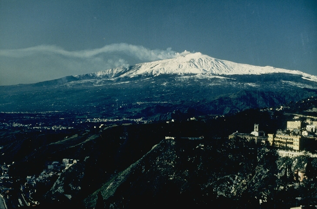 Etna Etna
Sicily Volcanic Province
|
The Sezione di Catania - Osservatorio Etneo (INGV) reported continuing activity at Etna during 31 March-6 April. Weather clouds occasionally obscured views of the summit area, though direct field observations occurred during 2-4 April. Minor, discontinuous Strombolian activity began at SE Crater at 2100 on 2 April and progressively intensified. From about 2250 on 2 April to 0050 on 3 April Strombolian activity was intense and ejected material onto the flanks of the cone. The activity slowly decreased and by 0600 explosions were no longer visible in webcam images. During the morning of 2 April ash emissions rose from Voragine Crater as high as 3.5 km a.s.l. and drifted mainly SE. A field team observed ashfall on the snow in the summit area. Ash emissions were again observed on 4 April. Minor and sporadic red ash emissions at Bocca Nuova Crater were observed during the week by INGV-OE personnel in the field.
Source: Sezione di Catania - Osservatorio Etneo (INGV)
|
Gede (Indonesia) | 2 April-8 April 2025 | Continuing ActivityCite this Report |
 Gede Gede
Sunda Volcanic Arc
|
The Pusat Vulkanologi dan Mitigasi Bencana Geologi (PVMBG) reported an increase in seismicity at Gede on 1 April. During March plumes (likely steam) rose 50-100 m above the rim of Wadon Crater and an average of 0-1 daily deep volcanic earthquakes were detected by the seismic network. The network recorded 47 deep volcanic earthquakes on 1 April. Seismicity decreased the next day, and no deep volcanic earthquakes were detected during 2-6 April. Plumes continued to rise as high as 100 m above the crater rim. One tornillo earthquake was recorded on 6 April. According to a news article the Balai Besar Taman Nasional Gunung Gede Pangrango (TNGGP) (the Gede national park) had already closed the volcano to climbers months before for unstated reasons and was scheduled to reopen on 3 April; the closure was extended to 7 April as a precaution due to the increased seismicity. The Alert Level remained at 1 (on a scale of 1-4) and the public was warned to stay 600 m away from Wadon Crater. The last eruption occurred in 1957 at Ratu Crater.
Sources: Pusat Vulkanologi dan Mitigasi Bencana Geologi (PVMBG, also known as CVGHM), Antara News
|
Great Sitkin (United States) | 2 April-8 April 2025 | Continuing ActivityCite this Report |
 Great Sitkin Great Sitkin
Aleutian Ridge Volcanic Arc
|
The Alaska Volcano Observatory (AVO) reported that slow lava effusion continued to feed a thick flow in Great Sitkin’s summit crater during 1-8 April. Small daily earthquakes were detected by the seismic network. Slightly elevated surface temperatures were observed in satellite data during 3-4 and 6-9 April. Weather clouds often obscured satellite and webcam views of the volcano. The Volcano Alert Level remained at Watch (the third level on a four-level scale) and the Aviation Color Code remained at Orange (the third color on a four-color scale).
Source: US Geological Survey Alaska Volcano Observatory (AVO)
|
Home Reef (Tonga) | 2 April-8 April 2025 | Continuing ActivityCite this Report |
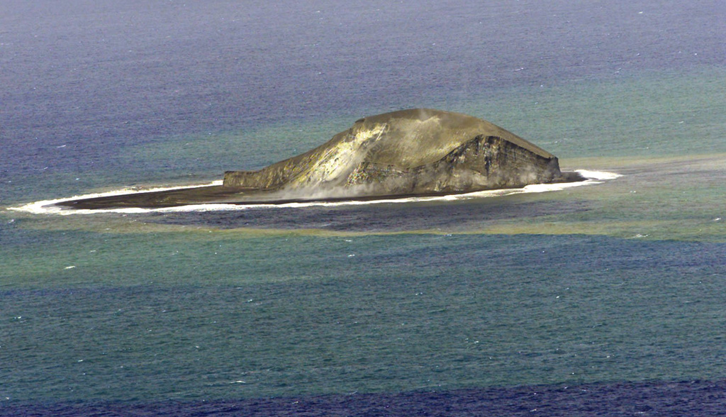 Home Reef Home Reef
Tofua Volcanic Arc
|
On 4 April the Tonga Geological Services reported that thermal anomalies at Home Reef were identified in satellite images during the previous two weeks; the anomalies were at mostly low levels, though they were occasionally characterized as moderate. A decrease in activity was detected in infrasound data. A lava dome just SW of the central part of the island was visible in a 26 March satellite image; this 80 m W-E, 100 m N-S feature had not changed in size since the previous view. Discolored water surrounding the island. The Maritime Alert Level remained at Orange (the third level on a four-level scale), and mariners were advised to stay at least 2 nautical miles (3.7 km) away from the island. The Aviation Color Code remained at Yellow (the second level on a four-level scale), and the Alert Level for residents of Vava’u and Ha’apai remained at Green (the first level on a four-level scale).
Source: Tonga Geological Services, Government of Tonga
|
Ibu (Indonesia) | 2 April-8 April 2025 | Continuing ActivityCite this Report |
 Ibu Ibu
Halmahera Volcanic Arc
|
The Pusat Vulkanologi dan Mitigasi Bencana Geologi (PVMBG) reported that the eruption at Ibu continued during 2-7 April. Daily dense gray ash plumes rose 300-1,000 m above the summit and drifted in multiple directions. Incandescence at the summit was visible in several webcam images posted with the reports. The Alert Level remained at 3 (the second highest level on a four-level scale) and the public was advised to stay 4 km away from the active crater and 5 km away from the N crater wall opening.
Source: Pusat Vulkanologi dan Mitigasi Bencana Geologi (PVMBG, also known as CVGHM)
|
Katmai (United States) | 2 April-8 April 2025 | Continuing ActivityCite this Report |
 Katmai Katmai
Alaska Peninsula Volcanic Arc
|
The Alaska Volcano Observatory (AVO) reported that during 6-7 and 9 April strong winds in the vicinity of Katmai and the Valley of Ten Thousand Smokes dispersed unconsolidated ash up to 1.5-1.8 km (5,000-6,000 ft) a.s.l. to the SE. The ash was originally deposited during the Novarupta-Katmai eruption in 1912. The Volcano Alert Level remained at Normal (the lowest level on a four-level scale) and the Aviation Color Code remained at Green (the lowest level on a four-color scale).
Source: US Geological Survey Alaska Volcano Observatory (AVO)
|
Kilauea (United States) | 2 April-8 April 2025 | Continuing ActivityCite this Report |
 Kilauea Kilauea
Hawaiian-Emperor Hotspot Volcano Group
|
The Hawaiian Volcano Observatory (HVO) reported that the eruption within Kilauea’s Kaluapele summit caldera, from vents along the SW margin of Halema’uma’u Crater, continued at variable levels during 1-8 April. Weak spattering at the N vent that had begun on 31 March changed to low lava fountaining and lava pond activity that ceased at 2122 on 1 April. Lava fountaining began at the S vent around 0800 on 1 April and rapidly increased in height, with fountains rising to 245 m. Volcanic gas emissions were elevated; during the period of high fountaining, sulfur dioxide emission rates were 50,000 tonnes per day along Highway 11, just NW of Halema’uma’u Crater. Small pumice, ash, and Pele’s hair fell on Highway 11, leaving deposits about 1 cm thick, and in closed areas of Hawai’i Volcanoes National Park. The fountain heights dropped significantly to 90 m by 0950 on 2 April and then ceased at 1203. Small spattering at the S vent was observed later in the afternoon. Lava covered about 50 percent of the crater floor.
Incandescence at the S vent was visible during 3-5 April and at the N vent during 4-7 April. During 3-7 April a dense white gas plume rose from the vents and bright sulfur deposits were visible on the vent cones. Lava flows were periodically active on the E crater floor. Incandescence at the S vent intensified at around 2120 on 7 April, indicating rising lava in the cone. Lava overflowed the vent at 2215 and spread across the crater floor. Low spatter fountains rising 5-30 m were visible at 0250 on 8 April. Spattering and activity at a lava pond in the N vent was visible at around 0400. The Volcano Alert Level remained at Watch (the third level on a four-level scale) and the Aviation Color Code remained at Orange (the third color on a four-color scale).
Source: US Geological Survey Hawaiian Volcano Observatory (HVO)
|
Lewotobi (Indonesia) | 2 April-8 April 2025 | Continuing ActivityCite this Report |
 Lewotobi Lewotobi
Sunda Volcanic Arc
|
The Pusat Vulkanologi dan Mitigasi Bencana Geologi (PVMBG) reported that eruptive activity at Lewotobi Laki-laki continued during 2-8 April. Dense gray ash plumes rose 300-1,200 m above the summit during 4-6 and 8 April and mainly drifted N, NE, and E, and occasionally SW. Minor incandescent at the summit was occasionally visible in webcam images posted with the daily reports. The Alert Level remained at 3 (on a scale of 1-4) and the public was warned to stay 6 km away from the center of Laki-laki.
Source: Pusat Vulkanologi dan Mitigasi Bencana Geologi (PVMBG, also known as CVGHM)
|
Lewotolok (Indonesia) | 2 April-8 April 2025 | Continuing ActivityCite this Report |
 Lewotolok Lewotolok
Sunda Volcanic Arc
|
The Pusat Vulkanologi dan Mitigasi Bencana Geologi (PVMBG) reported that an eruption at Lewotolok was ongoing during 2-8 April. White steam-and-gas plumes rose as high as 120 m above the summit of the cone and drifted NE, E, and SE on most days; white-and-gray plumes rose 30 m and drifted E on 3 April. Nighttime webcam images accompanying the daily reports often showed incandescent material being ejected above the summit, as far as 600 m from the vent during 3-4 April. Rumbling was heard on 3 April and a lava flow was visible, but it remained confined to the crater. The Alert Level remained at 2 (on a scale of 1-4) and the public was warned to stay 2 km away from the vent and 2.5 km away on the S, SE, and W flanks.
Source: Pusat Vulkanologi dan Mitigasi Bencana Geologi (PVMBG, also known as CVGHM)
|
Marapi (Indonesia) | 2 April-8 April 2025 | Continuing ActivityCite this Report |
 Marapi Marapi
Sunda Volcanic Arc
|
The Pusat Vulkanologi dan Mitigasi Bencana Geologi (PVMBG) reported that eruptive activity at Marapi’s Verbeek Crater (on Sumatra) continued during 2-8 April. An eruptive event at 2233 on 1 April was recorded by the seismic network but not observed. At 0625 on 2 April a gray ash plume rose 350 m above the summit and drifted NE and at 1604 a dense gray ash plume rose 1 km above the summit and drifted E. On 3 April at 1804 a dense gray ash plume rose 400 m and drifted E. At 0712 on 3 April an eruptive event that lasted one minute and nine seconds produced an ash plume that rose 1.5 km above the summit and drifted E. The Alert Level remained at 2 (on a scale of 1-4) and the public was warned to stay 3 km away from the active crater.
Source: Pusat Vulkanologi dan Mitigasi Bencana Geologi (PVMBG, also known as CVGHM)
|
Merapi (Indonesia) | 2 April-8 April 2025 | Continuing ActivityCite this Report |
 Merapi Merapi
Sunda Volcanic Arc
|
The Balai Penyelidikan dan Pengembangan Teknologi Kebencanaan Geologi (BPPTKG) reported that the eruption at Merapi (on Java) continued during 28 March-4 April. Seismicity was at higher levels than the previous week. The SW lava dome produced 28 lava avalanches that traveled as far as 1.8 km SW down the Bebeng drainage, 50 that traveled as far as 1.8 km SW down the Krasak drainage, and 37 that traveled as far as 1.8 km W down the Sat/Putih drainage. Slight morphological changes to the SW lava dome resulted from minor collapses of material. The Alert Level remained at 3 (on a scale of 1-4), and the public was warned to stay 3-7 km away from the summit, based on location.
Source: Balai Penyelidikan dan Pengembangan Teknologi Kebencanaan Geologi (BPPTKG)
|
Reventador (Ecuador) | 2 April-8 April 2025 | Continuing ActivityCite this Report |
 Reventador Reventador
Northern Andean Volcanic Arc
|
The Instituto Geofísico-Escuela Politécnica Nacional (IG-EPN) reported that eruptive activity continued at Reventador during 1-8 April. Seismicity included 52-127 daily explosions, long-period earthquakes, harmonic tremor, and tremor associated with emissions. Multiple daily ash-and-gas plumes rose as high as 1.3 km above the crater rim and drifted mainly NW, W, and SW. Webcams recorded multiple nightly instances of incandescent material descending the flanks as far as 1.2 km below the crater rim. On 2 April pyroclastic flows traveled 250 m down the SE flank and 700 m down the S flank. A pyroclastic flow traveled 500 m down the flank on 3 April. Secretaría de Gestión de Riesgos maintained the Alert Level at Orange (the second highest level on a four-color scale).
Sources: Instituto Geofísico-Escuela Politécnica Nacional (IG-EPN), Secretaría de Gestión de Riesgos (SGR)
|
Sangay (Ecuador) | 2 April-8 April 2025 | Continuing ActivityCite this Report |
 Sangay Sangay
Northern Andean Volcanic Arc
|
The Instituto Geofísico-Escuela Politécnica Nacional (IG-EPN) reported that moderate levels of eruptive activity continued at Sangay during 1-8 April. The seismic network recorded 36-185 daily explosions. Weather clouds obscured views most of the week, but on most of the days several gas-and-ash plumes were visible rising as high as 2 km above the summit and drifting SW. Crater incandescence was often visible during dark hours. Secretaría de Gestión de Riesgos (SGR) maintained the Alert Level at Yellow (the second highest level on a four-color scale).
Sources: Instituto Geofísico-Escuela Politécnica Nacional (IG-EPN), Secretaría de Gestión de Riesgos (SGR)
|
Santa Maria (Guatemala) | 2 April-8 April 2025 | Continuing ActivityCite this Report |
 Santa Maria Santa Maria
Central America Volcanic Arc
|
The Instituto Nacional de Sismología, Vulcanología, Meteorología e Hidrología (INSIVUMEH) reported ongoing, high-level eruptive activity at Santa Maria’s Santiaguito dome complex during 2-8 April with continuing lava extrusion at Caliente dome. Daily explosions, as many as five per hour when reported, generated gas-and-ash plumes that rose as high as 1.2 km above the dome and possibly drifted as far as 40 km N, NW, W, and SW. Effusion of blocky lava and collapses of material produced block avalanches that were sometimes heard several kilometers away; these mainly descended the SE, S, SW, and W flanks. Collapsed material sometimes produced short pyroclastic flows that descended the flanks in all directions. Incandescence was visible at Caliente dome and upper part of the SW flank lava flow. Ashfall was forecast for areas downwind on most days. Ashfall was reported in Finca El Patrocinio (8 km SW), San Marcos (10 km SW), Loma Linda (7 km W), Palajunoj (17 km SSW), Llanos de Pinal, and other nearby communities during 2-3 April, from Calahuaché (8 km SSE) to Viejo Palmar (11 km S) and Loma Linda during 6-7 April, and forecasted for areas downwind on most other days.
Source: Instituto Nacional de Sismologia, Vulcanologia, Meteorologia, e Hidrologia (INSIVUMEH)
|
Semeru (Indonesia) | 2 April-8 April 2025 | Continuing ActivityCite this Report |
 Semeru Semeru
Sunda Volcanic Arc
|
The Pusat Vulkanologi dan Mitigasi Bencana Geologi (PVMBG) reported that activity continued at Semeru during 2-8 April, with multiple eruptive events recorded daily by the seismic network. Dense white-and-gray ash plumes rose 400-900 m above the summit and drifted in multiple directions; plumes were not visible on 2 April. The Alert Level remained at 2 (the second lowest level on a scale of 1-4). The public was warned to stay at least 5 km away from the summit in all directions, 13 km from the summit to the SE, 500 m from the banks of the Kobokan drainage as far as 17 km from the summit, and to avoid other drainages including the Bang, Kembar, and Sat, due to lahar, avalanche, and pyroclastic flow hazards.
Source: Pusat Vulkanologi dan Mitigasi Bencana Geologi (PVMBG, also known as CVGHM)
|
Sheveluch (Russia) | 2 April-8 April 2025 | Continuing ActivityCite this Report |
 Sheveluch Sheveluch
Eastern Kamchatka Volcanic Arc
|
The Kamchatkan Volcanic Eruption Response Team (KVERT) reported that lava extrusion may have continued at Sheveluch’s “300 years of RAS” dome on the SW flank of Old Sheveluch and at the Young Sheveluch dome during 27 March-3 April. Thermal anomalies over the domes were identified in satellite images during 30-31 March and 1-3 April; weather clouds obscured views on the other days. The Aviation Color Code remained at Orange (the second highest level on a four-color scale). Dates are based on UTC times; specific events are in local time where noted.
Source: Kamchatkan Volcanic Eruption Response Team (KVERT)
|
Stromboli (Italy) | 2 April-8 April 2025 | Continuing ActivityCite this Report |
 Stromboli Stromboli
Aeolian Volcanic Arc
|
The Sezione di Catania - Osservatorio Etneo (INGV) reported that eruptive activity continued at Stromboli during 31 March-6 April. Webcam images showed Strombolian activity at four vents in Area N within the upper part of the Sciara del Fuoco and from at least two vents in Area C-S (South-Central Crater) on the crater terrace. The vents in Area N continued to produce low- to medium-intensity explosions at a rate of 8-12 events per hour, ejecting lapilli and bombs less than 150 m above the vents. Minor and discontinuous spattering at the N2 vent was intense for short periods on 31 March and 2 April. Explosions at the vents in Area C-S ejected tephra above the vent at a rate of 1-5 events per hour. The Alert Level remained at Yellow (the second lowest level on a four-level scale).
Source: Sezione di Catania - Osservatorio Etneo (INGV)
|
Suwanosejima (Japan) | 2 April-8 April 2025 | Continuing ActivityCite this Report |
 Suwanosejima Suwanosejima
Ryukyu Volcanic Arc
|
The Japan Meteorological Agency (JMA) reported that eruptive activity at Suwanosejima's Ontake Crater continued during 31 March-7 April. Incandescence was observed nightly in webcam images. An explosion at 2050 on 1 April generated an ash plume that rose 600 m above the crater and ejected large blocks as far as 200 m from the vent. The Alert Level remained at 2 (the second level on a five-level scale) and the public was warned to stay at least 1.5 km away from the crater.
Source: Japan Meteorological Agency (JMA)
|
Whakaari/White Island (New Zealand) | 2 April-8 April 2025 | Continuing ActivityCite this Report |
 Whakaari/White Island Whakaari/White Island
Taupo Volcanic Arc
|
The Wellington VAAC reported that low-level steam-and-gas emissions from Whakaari/White Island contained minor amounts of ash during 1-2 and 6 April. The emissions rose 0.9-1.8 km (3,000-6,000 ft) a.s.l. and drifted S and SE based on webcam and satellite images.
Source: Wellington Volcanic Ash Advisory Center (VAAC)
|
