Report on Poas (Costa Rica) — 2 April-8 April 2025
Smithsonian Institution / US Geological Survey
Weekly Volcanic Activity Report, 2 April-8 April 2025
Managing Editor: Sally Sennert.
Please cite this report as:
Global Volcanism Program, 2025. Report on Poas (Costa Rica) (Sennert, S, ed.). Weekly Volcanic Activity Report, 2 April-8 April 2025. Smithsonian Institution and US Geological Survey.
Poas
Costa Rica
10.2°N, 84.233°W; summit elev. 2697 m
All times are local (unless otherwise noted)
The Observatorio Vulcanológico y Sismológico de Costa Rica-Universidad Nacional (OVSICORI-UNA) reported elevated levels of activity at Poás during 2-8 April. Inflation continued to be detected, though the rate of uplift had slowed. Sulfur dioxide emissions remained high; values over 2,200 tonnes per day (t/d) were identified in satellite data on 30 March and were followed by two days of values exceeding 1,000 t/d. Emissions recorded by a mobile Differential Optical Absorption Spectroscopy (DOAS) instrument averaged 5,300 ± 500 t/d on 1 April.
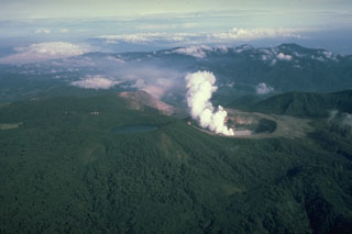
Phreatomagmatic events at Boca C occurred about every 4-12 minutes on most days during the week. The events produced almost continuous gas, steam, and ash plumes that generally rose up to 500 m and mostly drifted SE, S, SW, W, and NW, though the plumes occasionally rose higher. Notably, gas, steam, and ash plumes rose to 1 km on 29 March, to 3 km at 1252 on 4 April, to heights greater than 1 km at 1701 on 6 April and at 0203 on 7 April, and to 1.5 km at 0218 and 0224 on 8 April. Ashfall was reported by residents through the week; ashfall occurred on 4 April in Bajos del Toro (7 km WNW) and in areas to the S on 8 April including Poasito (7 km SW), San Juan Norte (9 km S), Savana Redonda (10 km SSE), San Pedro de Poás (14 km S), Poás (14 km S), Chilamate (16 km SSW), Pavas (16 km SE), Sabanilla (14 km SSE), Calle el Sitio 14 km S), Naranjo (16 km WSW), Cabuyal (8 km SW), Chilamate (16 km SSW), and Alajuela (20 km S). Explosions sometimes ejected incandescent blocks onto the crater floor. Weather conditions sometimes obscured views of the crater.
According to the Comisión Nacional de Emergencias (CNE) on 8 April the Alert Level Orange for the Parque Nacional volcán Poás remained in effect as well as for the district of Toro Amarillo in the Canton of Sarchí due to activity at the crater, ashfall and sulfur odors impacting areas downwind, and a higher potential of lahars in drainages. The volcano’s Alert Level remained at 3 (the second highest level on a four-level scale) and the Aviation Color Code remained at Orange (the second highest color on a four-color scale).
Geological Summary. The broad vegetated edifice of Poás, one of the most active volcanoes of Costa Rica, contains three craters along a N-S line. The frequently visited multi-hued summit crater lakes of the basaltic-to-dacitic volcano are easily accessible by vehicle from the nearby capital city of San José. A N-S-trending fissure cutting the complex stratovolcano extends to the lower N flank, where it has produced the Congo stratovolcano and several lake-filled maars. The southernmost of the two summit crater lakes, Botos, last erupted about 7,500 years ago. The more prominent geothermally heated northern lake, Laguna Caliente, is one of the world's most acidic natural lakes, with a pH of near zero. It has been the site of frequent phreatic and phreatomagmatic eruptions since an eruption was reported in 1828. Eruptions often include geyser-like ejections of crater-lake water.
Sources: Observatorio Vulcanologico y Sismologico de Costa Rica-Universidad Nacional (OVSICORI-UNA), Comisión Nacional de Prevención de Riesgos y Atención de Emergencias (CNE)